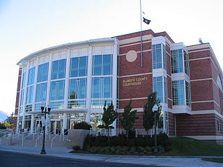
Klamath County is one of the 36 counties in the U.S. state of Oregon. As of the 2020 census, the population was 69,413. The county seat is Klamath Falls. The county was named for the Klamath, the tribe of Native Americans living in the area at the time the first European explorers entered the region. Klamath County comprises the Klamath Falls, OR Micropolitan Statistical Area.

Klamath Falls is a city in, and the county seat of, Klamath County, Oregon, United States. The city was originally called Linkville when George Nurse founded the town in 1867. It was named after the Link River, on whose falls the city was sited. The name was changed to Klamath Falls in 1893. The population was 21,813 at the 2020 census. The city is on the southeastern shore of the Upper Klamath Lake located about 246 miles (396 km) northwest of Reno, Nevada, and approximately 17 miles (27 km) north of the California–Oregon border.

Modoc Point is a cliff on the east shore of Upper Klamath Lake, in Klamath County, Oregon, United States, approximately 15 miles north of Klamath Falls on U.S. Route 97. It is part of the larger cliff known as Modoc Rim or Modoc Ridge.

Bly is an unincorporated community in Klamath County, Oregon, United States. By highway, it is about 50 miles (80 km) east of Klamath Falls. As of 2020, the population was 207.

Lost River begins and ends in a closed basin in northern California and southern Oregon in the United States. The river, 60 miles (97 km) long, flows in an arc from Clear Lake Reservoir in Modoc County, California, through Klamath County, Oregon, to Tule Lake in Siskiyou County, California. About 46 mi (74 km) of Lost River are in Oregon, and 14 miles (23 km) are in California.

Adel is an unincorporated community in southeastern Lake County, in the U.S. state of Oregon. The community is in an arid, sparsely populated part of the state, along Oregon Route 140, about 30 miles (48 km) east of Lakeview. The Warner Valley surrounding Adel contains many marshes and shallow lakes, most of them intermittent.
Beatty is an unincorporated community and census-designated place (CDP) in Klamath County, Oregon, United States. Beatty is along Oregon Route 140 at the confluence of the Sycan and Sprague rivers and is 40 miles (64 km) by highway northeast of Klamath Falls.
Sprague River is an unincorporated community in Klamath County, Oregon, United States. It is about 45 miles (72 km) northeast of Klamath Falls near the Sprague River, northwest of Oregon Route 140.
Dairy is an unincorporated community in Klamath County, Oregon, United States.

The OC&E Woods Line State Trail is a rail trail in Klamath and Lake counties in the U.S. state of Oregon. It is Oregon's longest state park. The trail follows the old OC&E and Weyerhaeuser railroads from Klamath Falls to Thompson Reservoir. Along its 105-mile (169 km) length it passes through the communities of Olene, Sprague River, Dairy, Beatty, and Bly.

Algoma is an unincorporated community on the east shore of Upper Klamath Lake, in Klamath County, Oregon, United States. It is about 8 miles (13 km) north of the city of Klamath Falls on U.S. Route 97. Algoma was named for the Algoma Lumber Company.
Pine Grove is an unincorporated community in Klamath County, Oregon, United States. Pine Grove lies south of Oregon Route 140 just east of its interchange with Oregon Route 39 near Altamont.
Pinehurst is an unincorporated community in Jackson County, Oregon, United States, on Oregon Route 66 about 25 miles (40 km) southeast of Ashland. It is along Jenny Creek near Round Prairie between the Siskiyou Mountains and the foothills of the Cascade Range.
Odessa is an unincorporated community in Klamath County, Oregon, United States. Odessa is along Oregon Route 140 south of Rocky Point and about 25 miles (40 km) northwest of Klamath Falls. Odessa lies along the western shore of Upper Klamath Lake near the Fremont–Winema National Forest.
Worden is an unincorporated community in Klamath County, Oregon, United States. It is about 14 miles (23 km) south of Klamath Falls and 3 miles (5 km) north of the Oregon–California border on U.S. Route 97.

Rocky Point is an unincorporated community in Klamath County, Oregon, United States. It is on Pelican Bay on the west shore of Upper Klamath Lake, about 29 miles (47 km) northwest of Klamath Falls and about 3 miles (5 km) north of Oregon Route 140 on Forest Highway 34. It is within the Winema National Forest.
Ady is an unincorporated historic locale in Klamath County, Oregon, United States.
Nuss Lake is a small private lake in Klamath Falls, Oregon, United States. It is 0.2 sq mi (0.52 km2) in size, located approximately 6.6 miles from Altamont. The lake sits between the south skirt of Stukel Mountain and Olene Gap to the north.
Hager is an unincorporated community in Klamath County, Oregon, United States. It is between Klamath Falls and Olene along Oregon Route 39 and Oregon Route 140.
Hildebrand is an unincorporated community in Klamath County, Oregon, United States. It lies along Bliss Road off Oregon Route 140 northeast of Dairy.


