Klarälven

Last updated • 6 min readFrom Wikipedia, The Free Encyclopedia
Klarälven
Sola i Karlstad.JPG
Map klaralven.tif
Topographic map of Klarälven river, where the area for the drainage basin for Klarälven is highlighted.
Location
Country Sweden, Norway
Physical characteristics
Source Rogen and Femund
Mouth Vänern
  location
Karlstad
  coordinates
59°23′19″N13°29′54″E / 59.38861°N 13.49833°E / 59.38861; 13.49833
  elevation
44 m (144 ft)
Length460 km (290 mi) [1]
Basin size11,820 km2 (4,560 sq mi) [1]
Discharge 
  average165 m3/s (5,800 cu ft/s) [1]
  maximum1,650 m3/s (58,000 cu ft/s) [1]

Klarälven ("The clear river" in Swedish [2] ) is a river flowing through Norway and Sweden. Together with Göta älv, which it is called as the river has passed through the lake Vänern, thus regarded as an entity, Göta älv—Klarälven is the longest river in Scandinavia and in the Nordic countries and its Swedish part the longest river of Sweden. These two rivers also have the largest drainage basin in the same areas, 50,229 km2 (19,394 sq mi) including all the rivers that run into Vänern, of which 42,468 km2 (16,397 sq mi) is located in Sweden and 7,761 km2 (2,997 sq mi) in Norway. [3]

Contents

The source of Gota alv/Klaralven at the northeast side of mount Brandstoten. Klaralvensource.jpg
The source of Göta älv/Klarälven at the northeast side of mount Brändstöten.

It emanates at the northeast side of Mount Brändstöten and flows through a couple of smaller lakes down to Lake Rogen in Härjedalen, Sweden, and then passes through the Norwegian Hedmark, where it flows through the lake Femunden. There it is known as Femundelva and Trysilelva. The rest of the river, the longest part, flows through Värmland to ultimately discharge in a delta into Vänern at Karlstad.

In its turn, Vänern drains then into Göta älv, reaching the sea at Gothenburg.

The river has historically provided significant economic benefits, providing a suitable transport route for log driving, and currently is internationally recognized as excellent sport fishing waters.

Geography and geology

Map of the Klaralven delta and accompanying water bodies. Not showed here are the southern branches of the west part of the delta. Delta klaralven.png
Map of the Klarälven delta and accompanying water bodies. Not showed here are the southern branches of the west part of the delta.

The watershed of Klarälven is commonly referred to as Klarälvdalen (the Klarälv basin), where it accumulates much of its water on its journey to Vänern. Other important sources of water are the snowy mountains in the northern areas of the watershed area, providing substantial flows in the spring when the snow melts; annual floods are common.

The straight river course north of Edebäck has been classified by Sten De Geer as a "tectonic valley" as it follows the Protogine Zone—a bedrock weakness zone of Precambrian age. [4] [5] During deglaciation of Scandinavia about 10,000 years before present the glacier ice retreated unevenly with the valley of Klarälven hosting a protruding ice tongue while the surrounding uplands were ice-free. The retreat of the ice left dead ice buried in the glacifluvial sediments of the valley. [6] The river course north of Edebäck formed an ancient fjord after it became free of glacier ice and before the post-glacial rebound definitely raised the valley bottom above the sea. The river course south of Edebäck is possibly a Quaternary deflection caused by the accumulation of glacial deposits. [4]

Since the end of the last ice age, the mouth of Klarälven has moved southward from Forshaga to its current position at Karlstad, [7] and is still moving, albeit for different reasons, as the river carries substantial quantities of sand, cut from the outer edges of its meandering curves, causing the shoreline of Vänern to constantly move southward.

The heavy meandering of Klarälven results in numerous oxbow lakes, formed as a result of a too sharp curve, eventually causing the river to create a new, shorter path. An artificial islet, Gubbholmen found in central Karlstad has also been created as a result of the accumulation of 5,000 tonnes (4,900 long tons; 5,500 short tons) of sand transported each day during the spring flood. [8]

Entering the Karlstad region, the river delta splits into two main parts and eight smaller parts. The east part splits into two further main branches after passing Gubbholmen (eventually three branches). The west part splits into five branches.

In the first half of the 20th century the geography and Quaternary geology Klarälven was studied by various Swedish researchers including Alfred Elis Törnebohm, Sten De Geer and Lennart von Post. This last Quaternary geologist died in 1951 leaving his research unfinished, despite this Klarälven was by 1956 the most studied river in Sweden. [4] Åke Sundborg's 1956 outstanding PhD thesis and publication on the geomorphology and hydrology of Klarälven is considered a major reference work for river studies in Sweden. [9]

Economic importance

There are some hydroelectric power plants in the river. These are the hydroelectric power plants from south to north.

  1. Forshaga power plant in Forshaga,
  2. Dejefors power plant in Deje, 20 MW
  3. Munkfors power plant in Munkfors, 33 MW,
  4. Skymnäsforsen power plant in Skymnäsfors, 17 MW,
  5. Forshult power plant in Forshult, 20 MW,
  6. Krakerud power plant in Krakerud, 22 MW,
  7. Skogaforsen power plant in Skogafors 15 MW,
  8. Edsforsen power plant in Edsfors 9 MW
  9. Höljes power plant in Höljes, 130 MW.

Fishing

In recent years,[ when? ] the sport fishing of Klarälven has gained an international recognition for its Atlantic salmon and brown trout fisheries; these two species of fish are sought after by fly fishers. Competition for use of areas rich in the popular species is vigorous, and at high season the price of fishing licenses may be as high as 500 Swedish krona (US$68) per day. Other measures are taken to ensure the survival of the fishery, including strict rules on the minimum sizes and quantities of fish allowed to be taken, as well as the requirement that unwanted fish, such as the northern pike, be killed when caught. [10]

Although the river was a busy log driving route, it has been reported that the fish populations of Klarälven has not suffered from the heavy activity, underwater life benefited from it, especially the grayling population. When the log driving stopped in 1991, it was later reported that the beneficial effects were slowly disappearing as shore vegetation grew denser, providing a less favourable environment for the fish. [11]

As of 1997, an upper secondary school specializing in sport fishing education was established to meet the demands for skilled professionals to guide fishing tourism. [12]

Other tourism

Klarälven has clean and fresh water, suitable for bathing, although caution must be taken if bathing at a point before the river reaches its delta, as the currents can be treacherous.[ citation needed ]

Modern day tourist attractions in addition to sport fishing include canoeing, as well as rafting from Branäs to Edebäck.

Log driving

A workforce of log drivers from Finnskoga, working at the Lusten separation point, Forshaga, taken 1918 Loggers klaralven.jpg
A workforce of log drivers from Finnskoga, working at the Lusten separation point, Forshaga, taken 1918
A stone bridge crossing the Klaralven delta in Karlstad. The red constructions were made to catch passing logs. Such constructions can be seen throughout Klaralven. Bridge klaralven.jpg
A stone bridge crossing the Klarälven delta in Karlstad. The red constructions were made to catch passing logs. Such constructions can be seen throughout Klarälven.

Log driving has been traced back to the 17th century, although log driving increased to a significant level at the beginning of the 20th century, when the paper industry started to expand. Log driving was accomplished by dumping the harvested logs into the river, there they floated until the separation point at Forshaga. They were then held up by a floating structure resembling a fence until loggers could move out on the logs, identify them and guide them to their designated areas using special hooks. After grouping logs with the same company marks together, the logs would then be towed to their destinations. [13]

As many as 1,500 people were working seasonally, employed by the local log drivers' society, paid by the paper mills and forest owners. Although a risky job, the personnel were skilled and only one drowning incident was reported in the last 30 years of operation. [11] Out of the 19 Lusten boats used to tow the logs to their final destinations, only one remains in working condition today; Lusten 8, serving as a tourist attraction. [14]

After the shutdown of the log driving industry in 1991, the remaining equipment was auctioned off, most was sold to the Forshaga Municipality, who used the equipment to found the log driving museum, using the old buildings used for the operations as its main building. Upon the shutdown of the flood driving in Klarälven, the practice of log driving in Sweden had officially come to its end.

Related Research Articles

<span class="mw-page-title-main">Göta älv</span> River in Sweden

The Göta älv is a river that drains lake Vänern into the Kattegat, at the city of Gothenburg, on the western coast of Sweden. It was formed at the end of the last glaciation, as an outflow channel from the Baltic Ice Lake to the Atlantic Ocean and nowadays it has the largest drainage basin in Scandinavia.

<span class="mw-page-title-main">Vänern</span> Largest lake in Sweden

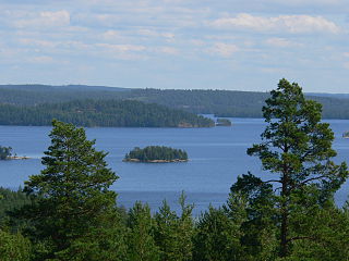
Vänern is the largest lake in Sweden, the largest lake in the European Union and the third-largest lake in Europe after Ladoga and Onega in Russia. It is located in the provinces of Västergötland, Dalsland, and Värmland in the southwest of the country. With its surface located at 44 metres (144 ft) with a maximum depth of 106 metres (348 ft), the lowest point of the Vänern basin is at 62 metres (203 ft) below sea level. The average depth is at a more modest 28 metres (92 ft), which means that the average point of the lake floor remains above sea level.

<span class="mw-page-title-main">Forshaga Municipality</span> Municipality in Värmland County, Sweden

Forshaga Municipality is a municipality in Värmland County in west central Sweden. Its seat is located in the town of Forshaga.

<span class="mw-page-title-main">Hammarö Municipality</span> Municipality in Värmland County, Sweden

Hammarö Municipality is a municipality in Värmland County in west central Sweden. Its seat is located in the town of Skoghall.

<span class="mw-page-title-main">Geats</span> Northern Germanic people

The Geats, sometimes called Goths, were a large North Germanic tribe who inhabited Götaland in modern southern Sweden from antiquity until the Late Middle Ages. They are one of the progenitor groups of modern Swedes, along with Swedes and Gutes. The name of the Geats also lives on in the Swedish provinces of Västergötland and Östergötland, the western and eastern lands of the Geats, and in many other toponyms.

<span class="mw-page-title-main">Dalsland</span> Historical province of Sweden

Dalsland is a Swedish traditional province, or landskap, situated in Götaland in southern Sweden. Lying to the west of Lake Vänern, it is bordered by Värmland to the north, Västergötland to the southeast, Bohuslän to the west, and Norway to the northwest.

<span class="mw-page-title-main">Värmland</span> Historical province of Sweden

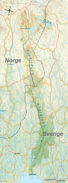
Värmland is a landskap in west-central Sweden. It borders Västergötland, Dalsland, Dalarna, Västmanland, and Närke, and is bounded by Norway in the west.

<span class="mw-page-title-main">Svealand</span> Core Region of Sweden

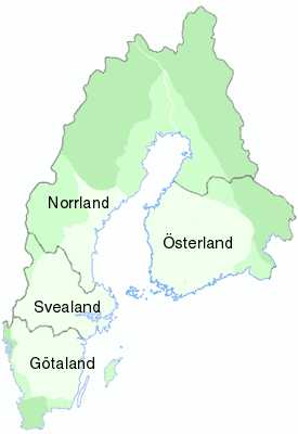
Svealand, or Swealand, is the historical core region of Sweden. It is located in south central Sweden and is one of three historical lands of Sweden, bounded to the north by Norrland and to the south by Götaland. Deep forests, Tiveden, Tylöskog, and Kolmården, separated Svealand from Götaland. Historically, its inhabitants were called Svear, from which is derived the English 'Swedes'.

<span class="mw-page-title-main">Ume River</span> River in Sweden

The Ume River is one of the main rivers in northern Sweden. It is around 460 km (290 mi) long, and flows in a south-eastern direction from its source, the lake Överuman by the Norwegian border within the Scandinavian mountain range. For large parts, the European route E12, also known as Blå Vägen, follows its path.

<span class="mw-page-title-main">Söderåsen</span> National park in southern Sweden

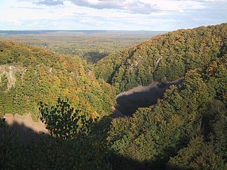
Söderåsen is a northwest–southwest elongated bedrock ridge in Scania in southern Sweden. On Söderåsen is Scania's highest point at 212 m (696 ft) above sea level. It is intersected by several fissure valleys. The ridge extends from Röstånga in the southeast to the Åstorp in northwest.

Eric Anundsson or Eymundsson was a semi-legendary Swedish king who supposedly ruled during the 9th century. The Norse sagas describe him as successful in extending his realm over the Baltic Sea, but unsuccessful in his attempts of westward expansion. There is no near-contemporary evidence for his existence, the sources for his reign dating from the 13th and 14th centuries. These sources, Icelandic sagas, are generally not considered reliable sources for the periods and events they describe.

<span class="mw-page-title-main">Karlstad</span> Episcopal see and municipal seat in Värmland, Sweden

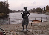
Karlstad is the 20th-largest city in Sweden, the seat of Karlstad Municipality, the capital of Värmland County, and the largest city in the province Värmland in Sweden. The city proper had 67,122 inhabitants in 2020 with 97,233 inhabitants in the wider municipality in 2023, and is the 21st biggest municipality in Sweden. Karlstad has a university and a cathedral.

<span class="mw-page-title-main">Trollhättan</span> Place in Västergötland, Sweden

Trollhättan is the 23rd-largest city in Sweden, the seat of Trollhättan Municipality, Västra Götaland County. It is situated by Göta älv, near the lake Vänern, and has a population of approximately 50,000 in the city proper. It is located 75 km (46 mi) north of Sweden's second-largest city, Gothenburg.

<span class="mw-page-title-main">Sommen</span>

Sommen is a lake in the South Swedish highlands lying across the border of the provinces of Östergötland and Småland. Situated about 147 metres above mean sea level, the lake has an area of 132 km2 (51 sq mi) and has a maximum depth of 60 metres. The lake is shared between the administrative kommunes of Ydre, Kinda, Boxholm and Tranås and the area around it is sparsely populated.

Ancylus Lake is a name given by geologists to a large freshwater lake that existed in northern Europe approximately from 9500 to 8000 years BC being in effect one of various predecessors to the modern Baltic Sea.

<span class="mw-page-title-main">Weichselian glaciation</span> Last glacial period and its associated glaciation in northern parts of Europe

The Weichselian glaciation was the last glacial period and its associated glaciation in northern parts of Europe. In the Alpine region it corresponds to the Würm glaciation. It was characterized by a large ice sheet that spread out from the Scandinavian Mountains and extended as far as the east coast of Schleswig-Holstein, northern Poland and Northwest Russia. This glaciation is also known as the Weichselian ice age, Vistulian glaciation, Weichsel or, less commonly, the Weichsel glaciation, Weichselian cold period (Weichsel-Kaltzeit), Weichselian glacial (Weichsel-Glazial), Weichselian Stage or, rarely, the Weichselian complex (Weichsel-Komplex).

<span class="mw-page-title-main">Vättern</span> Second largest lake in Sweden

Vättern is the second largest lake by surface area in Sweden, after Vänern, and the sixth largest lake in Europe. It is a long, finger-shaped body of fresh water in south central Sweden, to the southeast of Vänern, pointing at the tip of Scandinavia. Being a deep lake at 128 metres (420 ft) below sea level at its deepest point, Vättern is about 1/3 the surface area of Vänern but in spite of this contains roughly 1/2 of its water.

<span class="mw-page-title-main">Blockfield</span>

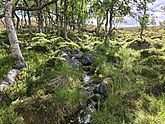
A blockfield, felsenmeer, boulder field or stone field is a surface covered by boulder- or block-sized rocks usually associated with a history of volcanic activity, alpine and subpolar climates and periglaciation. Blockfields differ from screes and talus slope in that blockfields do not apparently originate from mass wastings. They are believed to be formed by frost weathering below the surface. An alternative theory that modern blockfields may have originated from chemical weathering that occurred in the Neogene when the climate was relatively warmer. Following this thought the blockfields would then have been reworked by periglacial action.

<span class="mw-page-title-main">Höljes Hydroelectric Power Station</span> Dam in Torsby Municipality, Värmland County

Höljes Hydroelectric Power Station is a hydroelectric power plant on the Klarälven in Torsby Municipality, Värmland County, Sweden.

<span class="mw-page-title-main">Åke Sundborg</span> Swedish geographer (1921–2007)

Åke Sundborg was a Swedish geographer and geomorphologist known for his contributions to the hydrology and geomorphological dynamics of rivers. He was active at Uppsala University where he studied under the supervision of Filip Hjulström eventually succeeding him on the chair of physical geography. Besides his studies of rivers Sundborg made contributions on the climate of cities, the distribution of loess and the sedimentation of reservoirs and lakes. He studied rivers in Sweden as well as various large rivers in Africa and Asia.

References

  1. 1 2 3 4 "Klarälven". Nationalencyklopedin (in Swedish). Retrieved 14 July 2010.(subscription required)
  2. Page 168 of the Swedish Etymological Dictionary Svenskt ortnamnslexikon, published 2003 by the institute of Språk- och folkminnesinstitutet, Uppsala: The name Klarälven or Clara älv has been used since the beginning of the 18th century. Before that time the river had some other names, among them the most important name: Gautelfr i.e. Göta älv.
  3. Swedish Meteorological and Hydrological Institute (in Swedish) Archived 2018-09-28 at the Wayback Machine (Swedish Meteorological and Hydrological Institute).
  4. 1 2 3 Sundborg, Åke (1956). "The River Klaralven: A Study of Fluvial Processes". Geografiska Annaler . 38 (3): 238–316. doi:10.2307/520285. JSTOR   520285.
  5. Andréasson, Per-Gunnar; Rodhe, Agnes (1992). The Protogine Zone. Geology and mobility during the last 1.5 Ga (PDF) (Report). SKB technical report.
  6. Lundqvist, Jan (2003). "Deglaciation Pattern in Subaquatic: Supra-Aquatic Transitional Environment Illustrated by the Klarälven Valley System, Värmland, Western Sweden". Geografiska Annaler . 85 (1): 73–89. doi:10.1111/1468-0459.00190. S2CID   140586387.
  7. History of Forshaga published by the Genealogy Society of Värmland
  8. Dubbskadeexkursion den 22 juni [ permanent dead link ]
  9. "Kungl. Vetenskapsakademiens årsberättelse 2007" (PDF) (in Swedish). No. 81. Stockholm. 2008. pp. 30–31. Archived from the original (PDF) on 2018-07-04. Retrieved 2016-10-25.{{cite magazine}}: Cite magazine requires |magazine= (help)
  10. Rules for sport fishing Archived 2005-12-06 at the Wayback Machine
  11. 1 2 Lundén, Bo. Flottningen på Klarälven (1986)
  12. SportfiskeAkademin - om skolan Archived 2007-03-11 at the Wayback Machine
  13. Flottningens historia Archived 2007-09-28 at the Wayback Machine on Museum of Värmland
  14. Forshaga kanal Archived 2006-02-21 at the Wayback Machine