Kleinmachnow

Last updated
Kleinmachnow
DEU Kleinmachnow COA.svg
Location of Kleinmachnow within Potsdam-Mittelmark district
Kleinmachnow in PM.pngBeetzseeGolzowRosenauSchwielowseeWollin
Germany adm location map.svg
Red pog.svg
Kleinmachnow
Brandenburg location map.svg
Red pog.svg
Kleinmachnow
Coordinates: 52°24′13″N13°13′13″E / 52.40361°N 13.22028°E / 52.40361; 13.22028
Country Germany
State Brandenburg
District Potsdam-Mittelmark
Subdivisions2 Ortsteile
Government
   Mayor (201624) Michael Grubert [1] (SPD)
Area
  Total11.94 km2 (4.61 sq mi)
Elevation
42 m (138 ft)
Population
 (2021-12-31) [2]
  Total20,136
  Density1,700/km2 (4,400/sq mi)
Time zone UTC+01:00 (CET)
  Summer (DST) UTC+02:00 (CEST)
Postal codes
14532
Dialling codes 033203
Vehicle registration PM
Website www.kleinmachnow.de

Kleinmachnow is a municipality of about 20,000 inhabitants in the Potsdam-Mittelmark district, in Brandenburg, Germany. It is situated south-west of the borough of Steglitz-Zehlendorf and east of Potsdam.

Contents

First mentioned in the Landbuch of Karl IV in 1375, the Kleinmachnow played an important role at the Bäke beek / creek crossing, secured by multiple medieval castles. The last of these castles (none of which are preserved today) belonged to the Knights of Hake, a family who shaped the local history until the 20th century. The replacement of the Bäke (beek / creek) with the Teltow Canal in 1906 brought the village the now listed historic Kleinmachnow flood-gate.

In the first half of the 20th century, Kleinmachnow grew from a rural village to a suburban municipality of the Berlin metropolitan area. The construction of the Berlin Wall cut Kleinmachnow off from West Berlin. The community's location near the border meant it was relatively isolated in the GDR. Since the German reunification, Kleinmachnow has been part of the growth of the countryside areas outside of Berlin.

Geography

Kleinmachnow is bordered by the Teltow Canal in the south and by the city boundary of Berlin in the north, west and east, forming a kind of indentation in the district of Steglitz-Zehlendorf, which is a neighbouring borough. The municipality encompasses the settlement of Dreilinden.

During the Cold War period, the area could only be accessed from Teltow and Stahnsdorf via three bridges across the Teltow Canal, and access from Berlin-Zehlendorf was once again granted after 1990. Since 1996, Kleinmachnow has a separate motorway connection to the German federal motorway 115 in the west. The centre of Berlin is situated 19 km (12 mi) north-east of the town, and Potsdam 12 km (7.5 mi) east of the town.

Geology

Located in the southwestern part of Berlin and adjacent Brandenburg, Kleinmachnow sits on the Teltow Ground Moraine Plateau, carved into a turbulent relief of small-scale chains of hills formed from boulder clay and meltwater channels, interspersed with puddles and pools. Geologically, the youngest Vistula Ice Age, about 21,000 years ago, created a loose erosion in the Bäke Valley that made the construction of the Teltow Canal between the Seeberg and Weinberg possible. The Seeberg area, at 65 meters above sea level, is the highest elevation in the region.

The Buschgraben is a glacial meltwater channel, located on the southwest border of Berlin, stretching in a north–south direction between the localities of Berlin-Zehlendorf and Kleinmachnow, ending at the Teltowkanal northwest of Teltow. The region of Kleinmachnow contains several small bodies of water, formed from dead ice holes. The Meiereipfuhl in the Bannwald formerly held five ponds, this has since reduced with the Duellpfuhl an der Ginsterheide, Pferdepfuhl, and Pfuhl am Jägerstieg/Ecke Wolfswerder serving as receptacles for roadway surface water today.

History

Canal lock Kleinmachnow asv2021-03 img20 Machnower Schleuse.jpg
Canal lock

Kleinmachnow arose at the former Bäke creek, today replaced by the Teltow Canal built in 1906. Parvo Machenow was first mentioned in the 1375 land registry (Landbuch) of Emperor Charles IV, then also Brandenburg Elector. In medieval times the ford was controlled by a castle, recently held by the Hake noble family. Together with the canal the Kleinmachnow lock was erected, soon becoming a landmark.

From the early 20th century the former village developed to an affluent suburb of Berlin. In 1937 Wilhelm Ohnesorge, minister of the Reichspost, acquired the Hakeburg mansion as his residence and established a large research facility of communications-electronics here. In World War II Kleinmachnow was the site of a labour camp with about 5,000 inmates, including a subcamp of Sachsenhausen.

Crash site of LM316 in Kleinmachnow south of Berlin. Machnower See Crash Site.jpg
Crash site of LM316 in Kleinmachnow south of Berlin.

On the night of 2–3 December 1943, a Lancaster plane of the Royal Australian Air Force (flight LM 316) was shot down over Kleinmachnow, one of those killed being the well-known Norwegian writer and poet Nordahl Grieg, at the time serving as a war correspondent. (A memorial stone was unveiled at the site ( 52°23′51″N13°12′58″E / 52.39750°N 13.21611°E / 52.39750; 13.21611 ) in November 2003.)

In 1946 the Socialist Unity Party of Germany (SED) seized the Hakeburg, which hosted the party's academy in the following years. From 1961 to 1989 the municipality was girded by the Berlin Wall on three sides and the motorway near Dreilinden (today Bundesautobahn 115) was the site of a major border crossing, counterpart of the Allied checkpoint Bravo in West Berlin. Since German reunification Kleinmachnow has seen a major increase of population, while the restitution of numerous plots[ clarification needed ] in favour of those owners who had fled from the GDR led to fierce conflicts.

Demography

Prior to the First World War, Kleinmachnow, located at the outskirts of Berlin, maintained a hamlet-like atmosphere, with a population of less than 450. This figure drastically increased in the following years due to the development of Dreilinden and the northwest expansion of the Bürgerhaus housing estate by Adolf Sommerfeld. During the 15 years between 1926 and 1939, the inhabitants of Kleinmachnow grew from 944 to 12,565.

A considerable number of citizens migrated to the West until 1961 This was compensated for by an influx of new citizens and, following the reunification of Germany, the population remained relatively constant until 1995. Subsequently, due to the increase of restitution claims by the original property owners, as well as the allure of the area, the number of inhabitants doubled from the mid-1990s until today.

Kleinmachnow: Population development
within the current boundaries (2020) [3]
YearPop.±% p.a.
1875 176    
1890 181+0.19%
1910 401+4.06%
1925 840+5.05%
1939 12,565+21.32%
1950 13,743+0.82%
1964 13,817+0.04%
YearPop.±% p.a.
1971 14,304+0.50%
1981 13,159−0.83%
1985 12,435−1.40%
1990 11,613−1.36%
1995 11,283−0.57%
2000 15,796+6.96%
2005 18,367+3.06%
YearPop.±% p.a.
2010 19,890+1.61%
2015 20,655+0.76%
2016 20,644−0.05%
2017 20,608−0.17%
2018 20,564−0.21%
2019 20,376−0.91%
2020 20,406+0.15%

Religion

In 1539, Joachim II, the Elector of Brandenburg, initiated the Reformation, resulting in the conversion of Bradenburg from a primarily Catholic region to a mainly Protestant area. Initially, Lutheranism was the major denomination of the region, but was eventually joined by the Reformed Church.

The old village church was first constructed in 1597 as one of the earliest Protestant-style church buildings in the region. The building belonged to the landed property the von Hake family, who were recorded to have renounced their Catholicism prior to the Elector of Brandenburg. Subsequent to the expansion of the local area in the 1920s and 1930s, a parish hall was erected near the Jägersteig, which was upgraded to a church in 1953 and named the Evangelical Church of the Resurrection. As of August 2012 the church had 5,400 adherents.

In addition to the regional church congregation, an Evangelical Lutheran Free Church was based in Brandenburg from its inception in 1871. Following 1922, the congregation held services in the former sailors' convalescent home located on Zehlendorfer Damm. In May 2007, the congregation of approximately 70 attendees was officially named the Paul Gerhardt Congregation of the Evangelical Lutheran Free Church. The property was later sold to the rapper Bushido, and regular services were relocated to Teltow. [4]

Politics

Seats in the municipal assembly (Gemeindevertretung) as of 2019 elections [5]
PartySeats %
Christian Democratic Union 519.1
Social Democratic Party of Germany 519.0
The Left 38.8
Alliance 90/The Greens 724.6
Alternative for Germany 25.8
Free Democratic Party 27.2
PRO (independent)13.3

Mayors

Collaboration with neighbouring communities

In 1967, during the German Democratic Republic, the possibility of a merger of Kleinmachnow, Stahnsdorf and Teltow districts was first considered. In 1972, the three districts established an administrative and organizational alliance, nonetheless maintaining their individual legal status. Since the reunification of Germany in 1990, debate has persisted over the most effective administrative arrangement; ranging from merely informal cooperation, through contractual collaboration, to full amalgamation into a single large district. Despite the district area restructuring that occurred in Brandenburg from 2000 to 2003, Kleinmachnow remains and was unaffected.

The 2009 Berlin-Bradenburg State Development Plan led to a re-examination of the two-tier system of central places for Bradenburg, involving the establishment of "a framework for spatial development in the capital region of Berlin-Bradenburg". [8] The plan proposed four regional centres and fifty medium-sized centres. Teltow was noted as the sole medium centre for the region, which would result to reduced financial support for the Stahnsdorf and Kleinmachnow districts. The political dispute concerning this proposed change remains unconcluded. [9]

Sports

In 2001 and 2007, Eigenherd European School in Kleinmachnow was awarded for its sporting excellence by the Ministry of Education, Youth and Sport in Bradenburg.

In 2021, the district of Teltow joined forces with Kleinmachnow to create a four-day program for an international contingent of athletes participating in the Special Olympics World Sumer Games 2023, Berlin. As a result of their successful application, in 2022 Kleinmachnow was chosen to be the host town for Special Olympics Samoa. [10] This endeavour marked the largest district inclusion project to have taken place in Germany with over 200 towns participating in the endeavour. [11]

Kleinmachnow is one of the three home towns of the basketball team TKS 49ers.

Twinned towns

Notable people

Related Research Articles

<span class="mw-page-title-main">Potsdam-Mittelmark</span> District in Brandenburg, Germany

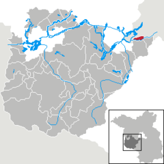
Potsdam-Mittelmark is a Kreis (district) in the western part of Brandenburg, Germany. Its neighbouring administrative units are the district of Havelland, the free cities of Brandenburg and Potsdam, the state of Berlin, the district of Teltow-Fläming, and the districts of Wittenberg, Anhalt-Bitterfeld and Jerichower Land in Saxony-Anhalt.

<span class="mw-page-title-main">Teltow-Fläming</span> District in Brandenburg, Germany

Teltow-Fläming is a Kreis (district) in the southwestern part of Brandenburg, Germany. Neighboring districts are Dahme-Spreewald, Elbe-Elster, the districts Wittenberg in Saxony-Anhalt, the district Potsdam-Mittelmark, and the Bundesland Berlin.

<span class="mw-page-title-main">Steglitz-Zehlendorf</span> Borough of Berlin in Germany

Steglitz-Zehlendorf is the sixth borough of Berlin, formed in Berlin's 2001 administrative reform by merging the former boroughs of Steglitz and Zehlendorf.

<span class="mw-page-title-main">Kloster Lehnin</span> Municipality in Brandenburg, Germany

Kloster Lehnin, or just Lehnin, is a municipality in the German state of Brandenburg. It lies about 24 km (15 mi) west-south-west of Potsdam.

<span class="mw-page-title-main">Province of Brandenburg</span> Province of Prussia, Germany

The Province of Brandenburg was a province of Prussia from 1815 to 1945. Brandenburg was established in 1815 from the Kingdom of Prussia's core territory, comprised the bulk of the historic Margraviate of Brandenburg and the Lower Lusatia region, and became part of the German Empire in 1871. From 1918, Brandenburg was a province of the Free State of Prussia until Prussia was dissolved in 1945 after World War II, and replaced with reduced territory as the State of Brandenburg in East Germany, which was later dissolved in 1952. Following the reunification of Germany in 1990, Brandenburg was re-established as a federal state of Germany, becoming one of the new states.

<span class="mw-page-title-main">Teltow</span> Town in Brandenburg, Germany

Teltow [German pronunciation:['tɛltoː] ] is a town in the Potsdam-Mittelmark district, in Brandenburg, Germany.

<span class="mw-page-title-main">Beelitz</span> Town in Brandenburg, Germany

Beelitz is a historic town in Potsdam-Mittelmark district, in Brandenburg, Germany. It is chiefly known for its cultivation of white asparagus.

<span class="mw-page-title-main">Stahnsdorf</span> Municipality in Brandenburg, Germany

Stahnsdorf is a municipality in the Potsdam-Mittelmark district, in Brandenburg, Germany.

<span class="mw-page-title-main">Schwielowsee (municipality)</span> Municipality in Brandenburg, Germany

Schwielowsee is a municipality in the Potsdam-Mittelmark district, in Brandenburg, Germany. It is situated on the shore of the Schwielowsee lake, through which the River Havel flows. The municipality was founded on December 31, 2002 in merger of the three villages Caputh, Geltow and Ferch. The Caputh Ferry, a cable ferry across the Havel, links Caputh and Geltow. In the east Schwielowsee shares border with the City of Potsdam, in the west with the town of Werder (Havel).

<span class="mw-page-title-main">Wusterwitz</span> Municipality in Brandenburg, Germany

Wusterwitz is a municipality in the Potsdam-Mittelmark district, in Brandenburg, Germany. Wusterwitz has a population of approximately 3,000 inhabitants.

<span class="mw-page-title-main">Griebnitzsee</span>

Griebnitzsee is a lake at the south-western outskirts of Berlin, the capital city of Germany. At an elevation of 29.4 m, its surface area is ca. 0.592 km². The lake forms the border between the German states of Berlin and Brandenburg. It is bordered in the north by the Wannsee district of Berlin, and in the south and west by the Babelsberg district of Potsdam in Brandenburg.

<span class="mw-page-title-main">Teltow Stadt station</span>

Teltow Stadt (town) station is located about 500 metres (1,600 ft) east of the centre of Teltow in the German state Brandenburg to the south of Berlin on the Berlin-Lichterfelde Süd–Teltow Stadt railway. The line and the station were opened on 24 February 2005. It has two tracks next to an island platform and is located in a cutting. Mahlower Straße crosses over it on a bridge. Stairs and a lift connect the station to the street. Although the town of Teltow is in the Potsdam-Mittelmark district, the station is in the adjoining Teltow-Fläming district. The station should not be confused with Teltow railway station, which is 2 kilometres (1.2 mi) to the south-east on the Anhalt Railway itself, and is served by Regional-Express lines 3, 4 and 5.

<span class="mw-page-title-main">Nikolassee</span> Quarter of Berlin in Germany

Nikolassee is a locality (Ortsteil) of Berlin in the borough (Bezirk) of Steglitz-Zehlendorf, named after the small Nikolassee lake. Located in the affluent Southwest of the city, the area comprises parts of the Schlachtensee neighbourhood and the eastern shore of the Großer Wannsee lake with the large Strandbad Wannsee lido, as well as the islets of Schwanenwerder and Lindwerder.

<span class="mw-page-title-main">Berlin–Magdeburg railway</span>

The first section of the Berlin–Magdeburg Railway was opened in 1838 as the Berlin-Potsdam Railway and was the first railway line in Prussia. In 1846 it was extended to Magdeburg.

<span class="mw-page-title-main">Teltow Canal</span>

The Teltow Canal, also known as the in German, is a canal to the south of Berlin, the capital city of Germany. The canal lies in both the states of Berlin and Brandenburg, and at points forms the boundary between the two. It takes its name from the Brandeburgian region of Teltow and town of Teltow which lie on its course. The canal was constructed between 1900 and 1906, when it was opened by Wilhelm II.

<span class="mw-page-title-main">Berlin/Brandenburg Metropolitan Region</span> Place in Germany

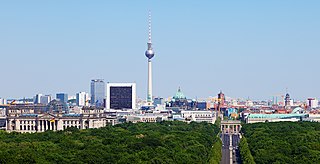
The Berlin/Brandenburg metropolitan region or capital region is one of eleven metropolitan regions of Germany, consisting of the entire territories of the state of Berlin and the surrounding state of Brandenburg. The region covers an area of 30,545 square kilometres (11,793 sq mi) with a total population of about 6.2 million.

<span class="mw-page-title-main">Teltow station</span>

Teltow station is located in the town of Teltow on the Anhalt Railway south of Berlin and was opened in 1901. Since then, the station has been repeatedly remodelled. The station served regional passenger and freight traffic and was the terminus of a Berlin S-Bahn service from 1950 to 1961. The direct connection to Berlin was lost with the construction of the Berlin Wall in 1961. It was restored in 2006.

<span class="mw-page-title-main">Brandenburg an der Havel – Potsdam-Mittelmark I – Havelland III – Teltow-Fläming I</span> Federal electoral district of Germany

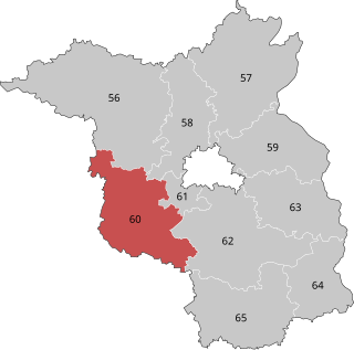
Brandenburg an der Havel – Potsdam-Mittelmark I – Havelland III – Teltow-Fläming I is an electoral constituency represented in the Bundestag. It elects one member via first-past-the-post voting. Under the current constituency numbering system, it is designated as constituency 60. It is located in western Brandenburg, comprising the city of Brandenburg an der Havel, most of the Potsdam-Mittelmark district, and parts of the Havelland and Teltow-Fläming districts.

<span class="mw-page-title-main">Teltow (region)</span>

Teltow is both a geological plateau and also a historical region in the German states of Brandenburg and Berlin. As an historical region, the Teltow was one of the eight territories out of which the March of Brandenburg was formed in the 12th and 13th centuries. As a result of the Teltow War (1239–1245) the question of territorial lordship of the newly created heart of the expanding march was finally decided here. Between 1835 and 1952 there was also a county, Teltow district; in addition a town immediately south of Berlin, in the present-day county of Potsdam-Mittelmark, bears the name Teltow.

<span class="mw-page-title-main">Potsdam – Potsdam-Mittelmark II – Teltow-Fläming II</span> Federal electoral district of Germany

Potsdam – Potsdam-Mittelmark II – Teltow-Fläming II is an electoral constituency represented in the Bundestag. It elects one member via first-past-the-post voting. Under the current constituency numbering system, it is designated as constituency 61. It is located in western Brandenburg, comprising the city of Potsdam and small parts of the Potsdam-Mittelmark and Teltow-Fläming districts.

References

  1. Landkreis Potsdam-Mittelmark Wahl der Bürgermeisterin / des Bürgermeisters, accessed 2 July 2021.
  2. "Bevölkerungsentwicklung und Flächen der kreisfreien Städte, Landkreise und Gemeinden im Land Brandenburg 2021" (PDF). Amt für Statistik Berlin-Brandenburg (in German). June 2022.
  3. Detailed data sources are to be found in the Wikimedia Commons.Population Projection Brandenburg at Wikimedia Commons
  4. "Paul-Gerhardt Gemeinde – Evangelisch-Lutherische Freikirche" (in German). Retrieved 2023-07-06.
  5. "Der Landeswahlleiter – Brandenburger Wahlergebnisse" [Brandenburg Election Results]. wahlergebnisse.brandenburg.de (in German). State of Brandenburg. Retrieved 18 August 2023.
  6. "Gesetz über die Kommunalwahlen im Land Brandenburg (Brandenburgisches Kommunalwahlgesetz - BbgKWahlG)". bravors.brandenburg.de. Retrieved 2023-07-07.
  7. "Kleinmachnow | Landkreis Potsdam-Mittelmark | Ergebnisse der Bürgermeisterwahlen | Wahlen". 2016-12-08. Archived from the original on 2016-12-08. Retrieved 2023-07-07.
  8. Gemeinsame Landesplanungsabteilung der Länder Berlin und Brandenburg, Land Bradenburg (19 January 2016). "Landesentwicklungsplan Berlin-Brandenburg, 31. März 2009" (PDF). Archived from the original (PDF) on 2016-01-19. Retrieved 2023-07-07.
  9. Potsdamer Neueste Nachrichten (5 September 2006). "Keine Motivation für Zusammenarbeit". Archived from the original on 17 December 2016. Retrieved 7 July 2023.
  10. Special Olympics World Games Berlin 2023, Organizing Committee gGmbH. "Special Olympics World Games Berling 2023" (PDF). www.berlin2023.org. Retrieved 13 May 2023.
  11. "Host Town Program". Berlin 2023 (in German). Retrieved 2023-07-07.

Commons-logo.svg Media related to Kleinmachnow at Wikimedia Commons