Klingenthal

Last updated

Klingenthal
Klingenthal blick zentrum.jpg
January 2010 view of Central Klingenthal
Flag of Klingenthal, Saxony.svg
Klingenthal coat of arms new.svg
Location of Klingenthal within Vogtlandkreis district
Klingenthal in V.svgAuerbachBergenFalkensteinGrünbachLimbachNeumarkNeustadtOelsnitzRosenbachSchöneckSteinberg
Germany adm location map.svg
Red pog.svg
Klingenthal
Saxony location map.svg
Red pog.svg
Klingenthal
Coordinates: 50°22′1″N12°28′07″E / 50.36694°N 12.46861°E / 50.36694; 12.46861
Country Germany
State Saxony
District Vogtlandkreis
Government
   Mayor (202229) Judith Sandner [1] (FW)
Area
  Total50.44 km2 (19.47 sq mi)
Elevation
569 m (1,867 ft)
Population
 (2022-12-31) [2]
  Total7,764
  Density150/km2 (400/sq mi)
Time zone UTC+01:00 (CET)
  Summer (DST) UTC+02:00 (CEST)
Postal codes
08248,
08267 (Zwota)
Dialling codes 037467,
037465 (Mühlleithen)
Vehicle registration V, AE, OVL, PL, RC
Website www.klingenthal.de

Klingenthal is a town in the Vogtland region, in Saxony, south-eastern Germany.

Contents

Geography

Klingenthal is situated directly on the border with the Czech Republic opposite the Czech town of Kraslice, 29 km southeast of Plauen, and 33 km northwest of Karlovy Vary. It is part of the Musikwinkel, a historical center of musical instrument manufacturing.

The Aschberg ("cinder mountain") towers above the town at 936 m. The extremely elongated town, 10.5 km from end to end, is surrounded by numerous woods of firs.

The town is bisected by the Brunndöbra and Svatava rivers. These two rivers unite at the Czech-German border to form the Svatava river, which in turn flows into the Ohře river at Sokolov.

History

First documented mention in neighboring Schoneck's church register Erste erwahnung klingenthals.png
First documented mention in neighboring Schöneck's church register

In 1591, Sebastian Köppel established a hammer mill near the border to Bohemia on the banks of the Zwota in order to capitalize on the rich deposits of iron ore and the region's vast supplies of wood, both for building and charcoal production. On 1 February 1602, there was the first documented mention of the "Höllhammer" (in English approximately: "Hell Hammer" or "Hollow Hammer") in the neighboring town of Schöneck's church register. At that time, blacksmiths, miners and charcoal makers were living there. In 1628, the hammer mill burned down and was only partly rebuilt.

In mid-17th century, Bohemian emigrants fleeing the Counter-Reformation brought the luthier's craft to Klingenthal, which – after the Peace of Westphalia – was a safe haven for Protestants.

The original wooden Zum Friedefursten Church of Klingenthal in 1726 Kirche zu Friedefursten alt.png
The original wooden Zum Friedefürsten Church of Klingenthal in 1726

In 1716, the foundation of a luthiers' guild was celebrated. Towards the end of the 18th century, bow makers' and string makers' crafts came to Klingenthal, but also the production of wood and brass wind instruments. In 1829, mouthharp production followed and in 1852, accordion production began. In the second half of the 19th century, the production of mouthharps, accordions and other more complex instruments had mostly displaced older branches of musical instrument production.

In 1875, Klingenthal was connected to railway services.

On 1 October 1919, Klingenthal received its town charter; on 1 July 1950 Sachsenberg-Georgenthal were incorporated into the town.

On 25 July 1952, parts of the former districts of Auerbach and Oelsnitz were cut off to form the district of Klingenthal. From 1949 to 1990, Klingenthal was home to the Klingenthaler Harmonikawerke, a state-owned company that was the main producer of accordions, harmonicas, and electronic instruments in East Germany.

Klingenthal Marktplatz Klingenthal.jpg
Klingenthal

On 1 April 1992, Mühlleithen, a settlement on the north-western crest of the Aschberg, was incorporated.

Since 1996, Klingenthal is part of the newly formed Vogtlandkreis. In contrast to Klingenthal, Bas-Rhin, this towns name was Klingenthal/Sa. (Sa. standing for Saxony). By decision of the town government, the Sa. appendix was annulled in January 2007. Ever since, the town's name is just Klingenthal.

Economy

While traditionally, the town has been a manufacturing center of musical instruments, it is also a ski resort. One of the main branches of Klingenthal's today's economy is tourism. It is home to the Baroque Zum Friedefürsten round church.

In 2005 Vogtlandarena was ready for use and there are now competitions in the Nordic Combined World Cup and Ski Jumping World Cup. It has already been a national centre for ski jumping during GDR time.

Vogtlandarena Vogtland Arena.jpg
Vogtlandarena

Notable people

Related Research Articles

<span class="mw-page-title-main">Zschopau</span> Town in Saxony, Germany

Zschopau, is a town in the Erzgebirgskreis district of Saxony, Germany.

<span class="mw-page-title-main">Mittweida</span> Town in Saxony, Germany

Mittweida is a town in Saxony, Germany, in the Mittelsachsen district.

<span class="mw-page-title-main">Adorf</span> Town in Saxony, Germany

Adorf is a small town and municipality in the Vogtlandkreis to the south-west of the Free State of Saxony, Germany. Gettengrün, a village within the municipality, borders on the Czech Republic.

<span class="mw-page-title-main">Königstein, Saxony</span> Town in Saxony, Germany

Königstein is a town on the river Elbe in Saxony in Germany. Königstein lies in the Sächsische Schweiz-Osterzgebirge District and had a population of 2,089 in 2018. It includes land on both banks of the Elbe, but the centre and most of the town lies to the south of the river. The Königstein Fortress is situated above and to the south-west of the town.

<span class="mw-page-title-main">Frankenberg, Saxony</span> Town in Saxony, Germany

Frankenberg is a town in the district of Mittelsachsen, in Saxony, Germany. It is situated on the river Zschopau, 12 km (7.46 mi) northeast of Chemnitz, and some 40 km (24.85 mi) north of the border to the Czech Republic.

<span class="mw-page-title-main">Oelsnitz, Erzgebirge</span> Town in Saxony, Germany

Oelsnitz is a town in the district Erzgebirgskreis, in Saxony, Germany. It is situated 14 km east of Zwickau, and 20 km southwest of Chemnitz. Between 1844 and 1971 hardcoal was mined in Oelsnitz and the surrounding towns. The major mine "Karl-Liebknecht" became a mining museum in 1986.

<span class="mw-page-title-main">Olbernhau</span> Town in Saxony, Germany

Olbernhau is a town in the district Erzgebirgskreis, in Saxony, Germany. It is situated in the Ore Mountains, 35 km southeast of Chemnitz, and 23 km north of Chomutov, Czech Republic.

<span class="mw-page-title-main">Neustadt in Sachsen</span> Town in Saxony, Germany

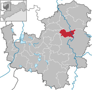
Neustadt in Sachsen is a town in the Sächsische Schweiz-Osterzgebirge district, in Saxony, Germany. It is situated near the border with the Czech Republic, 35 km east of Dresden (centre), and 23 km southwest of Bautzen. At Neustadt, there is an Observation Tower at Goetzinger's Height, one of the oldest lattice towers in the world.

<span class="mw-page-title-main">Bad Elster</span> Town in Saxony, Germany

Bad Elster is a spa town in the Vogtlandkreis district, in Saxony, Germany. It lies on the border of Bavaria and the Czech Republic in the Elster gebirge hills. It is situated on the river White Elster, and is protected from extremes of temperature by the surrounding wooded hills. It is 25 kilometres (16 mi) southeast of Plauen, and 25 kilometres (16 mi) northwest of Cheb. It is part of the Freunde im Herzen Europas microregion.

<span class="mw-page-title-main">Jöhstadt</span> Town in Saxony, Germany

Jöhstadt is a town in the district of Erzgebirgskreis, in Saxony, Germany. It is situated in the Ore Mountains, on the border with the Czech Republic, 10 km southeast of Annaberg-Buchholz, and 35 km northeast of Karlovy Vary.

<span class="mw-page-title-main">Markneukirchen</span> Town in Saxony, Germany

Markneukirchen is a town in the Vogtlandkreis district, in Saxony, Germany, close to the Czech border. It lies in the Elster Mountains, 24 km (14.9 mi) southeast of Plauen, and 14 km (8.7 mi) northeast of Aš.

<span class="mw-page-title-main">Neusalza-Spremberg</span> Town in Saxony, Germany

Neusalza-Spremberg is a town in the district Görlitz, in Saxony, Germany. It is situated on the border with the Czech Republic, on the river Spree, 6 km northwest of Ebersbach, and 17 km southeast of Bautzen.

<span class="mw-page-title-main">Oberwiesenthal</span> Town in Saxony, Germany

Oberwiesenthal is a town and a ski resort in the district of Erzgebirgskreis in Saxony in Germany. It is situated in the Ore Mountains, on the border with the Czech Republic, 19 km south of Annaberg-Buchholz, and 23 km northeast of Karlovy Vary. At 914 metres (2,999 ft), it is the highest town in Germany. The Olympic and World Championships goldmedalist in ski jumping Jens Weißflog competed for SC Tractor Oberwiesenthal and Oberwiesenthaler SV.

<span class="mw-page-title-main">Sayda, Saxony</span> Town in Saxony, Germany

Sayda is a town in the district of Mittelsachsen, in Saxony, Germany. It is situated 24 km south of Freiberg, and 28 km north of Chomutov.

<span class="mw-page-title-main">Schöneck, Saxony</span> Town in Saxony, Germany

Schöneck is a town in the Vogtlandkreis district, in the Free State of Saxony, Germany. It is situated 18 km (11 mi) southeast of Plauen, and 35 km (22 mi) north of Cheb. Schöneck is known as the biggest ski resort in the eastern part of Germany. With more than 700 m (church) it is the highest-located town in the Vogtland district. It is in the 'music corner', a region so-called because of its history of production of musical instruments.

<span class="mw-page-title-main">Trebsen</span> Town in the Leipzig district in Saxony, Germany

Trebsen is a town in the Leipzig district, in Saxony, Germany. It is situated on the river Mulde, 6 km northeast of Grimma, and 27 km east of Leipzig (centre).

<span class="mw-page-title-main">Lichtenstein, Saxony</span> Town in Saxony, Germany

Lichtenstein is a town in the Zwickau district, in Saxony, Germany. It is situated 11 km northeast of Zwickau, and 22 km southwest of Chemnitz. It was owned by the House of Schönburg from 1286 until 1945.

<span class="mw-page-title-main">Elstertrebnitz</span> Municipality in Saxony, Germany

Elstertrebnitz is a municipality in Saxony, lying southwest of Leipzig and northeast of Zeitz.

<span class="mw-page-title-main">Großschönau, Saxony</span> Municipality in Saxony, Germany

Großschönau is a municipality in the district Görlitz, in Saxony, Germany located in the cross-border region with the Czech Republic. It used to be a famous Upper Lusatian center of Damask fabric production until the end of the 1980s. Since then it has turned into an area of tourism.

<span class="mw-page-title-main">Aschberg</span>

The Aschberg is a mountain on the border of Germany (Saxony) and the Czech Republic. It is part of the Ore Mountains. The summit lies on the Czech side, in the municipality of Bublava.

References

  1. Wahlergebnisse 2022, Statistisches Landesamt des Freistaates Sachsen. Retrieved 6 July 2023.
  2. "Einwohnerzahlen nach Gemeinden als Excel-Arbeitsmappe" (XLS) (in German). Statistisches Landesamt des Freistaates Sachsen. 2024.