
Kapalua is a census-designated place (CDP) in Maui County, Hawaiʻi, United States. A resort development by the Maui Land & Pineapple Company extends inland from Kapalua Bay and Honolua Bay. The population was 353 at the 2010 census.

Kīhei is a census-designated place (CDP) in Maui County, Hawaiʻi, United States. The population was 20,881 at the 2010 census.

Lahaina is the largest census-designated place (CDP) in West Maui, Maui County, Hawaii, United States and includes the Ka'anapali and Kapalua beach resorts. As of the 2010 census, the CDP had a resident population of 11,704. Lahaina encompasses the coast along Hawaii Route 30 from a tunnel at the south end, through Olowalu and to the CDP of Napili-Honokowai to the north. During the tourist season, the population can swell to nearly 40,000 people.
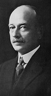
Henry Alexander Baldwin or Harry Alexander Baldwin was a sugarcane plantation manager, and politician who served as Congressional Delegate to the United States House of Representatives representing the Territory of Hawaii. He was one of the earliest leaders of the Hawaii Republican Party.

Mākena State Park comprises 165 acres (0.7 km2) in Makena, south of Wailea on the island of Maui, Hawaii. It contains three separate beaches and a dormant volcanic cinder cone.

Puʻunēnē is an unincorporated community in the central part of Maui, Hawaii, near Kahului. Although the land in that area is fairly level, the words Puʻu nēnē mean "nene goose hill" in Hawaiian. With a population of around 50, Puʻunēnē's primary industry is growing, harvesting and processing sugarcane.

Peʻahi is a place on the north shore of the island of Maui in the U.S. state of Hawaii. It has lent its name to a big wave surfing break, also known as Jaws.

La Perouse Bay or Keoneʻōʻio Bay is located south of the town of Wailea, Hawaii at the end of Mākena Alanui Road at 20°35′54″N156°25′12″W. The bay's Hawaiian name is Keoneʻōʻio. It was later named for the French explorer Captain Jean-François de Galaup, comte de La Pérouse. In 1786, La Pérouse surveyed and mapped the prominent embayment near the southern cape of Maui opposite the island of Kahoʻolawe. The bay is the site of Maui's most recent volcanic activity. The rounded peninsula that dominates the northern half of the bay and extends up the coast a short distance was formed about 900,000 years ago by an eruption of basaltic lava that originated in the southernmost landward expression of the Haleakalā Southwest Rift Zone. A small string of cinder cones extending inland to the northeast marks the axis of the rift zone.

Honolua Bay, Mokuleʻia Bay and Lipoa Point are part of an area known as the ahupuaʻa of Honolua, located just north of Kapalua, West Maui in Maui County, Hawaiʻi, United States. The area is a mix of agricultural and conservation land tended by the Maui Land & Pineapple Company in Lahaina, Hawaiʻi, including coastline management. Honolua Bay and Mokuleʻia Bay comprise the 45-acre (18 ha) Honolua-Mokuleʻia Marine Life Conservation District.

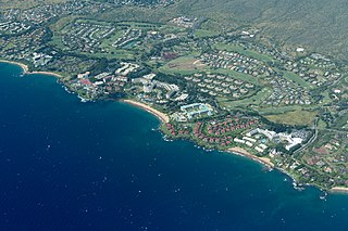
Kapalua Resort is a golf and beach resort in Kapalua, Hawaii on the northwest shore of the island of Maui near Lahaina, Hawaii. It is owned by Maui Land & Pineapple Company.

Waiola Church is the site of a historic mission established in 1823 on the island of Maui in Hawaii. Originally called Waineʻe Church until 1953, the cemetery is the final resting place for early members of the royal family of the Kingdom of Hawaii.
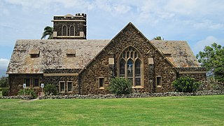
Makawao Union Church is a church near Makawao on the Hawaiian island of Maui. It was founded by New England missionary Jonathan Smith Green during the Kingdom of Hawaii. The third historic structure used by the congregation was designed by noted local architect C.W. Dickey and dedicated in 1917 as the Henry Perrine Baldwin Memorial Church. In 1985, Makawao Union Church was placed on the Hawaii and National Register of Historic Places.
The Haʻikū Sugar Mill was a processing factory for sugarcane from 1861 to 1879 on the island of Maui in Hawaii.
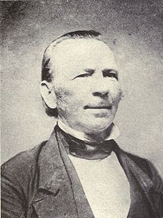
Jonathan Smith Green was a missionary from New England to the Kingdom of Hawaii.
Wailea is a census-designated place (CDP) in Maui County, Hawaiʻi, United States. As of the 2010 census, it had a population of 5,938. Prior to 2010, the area was part of the Wailea-Makena census-designated place. The community was developed in 1971 by a partnership of Alexander & Baldwin and Northwestern Mutual.

Spreckelsville is an unincorporated community on the northern coast of the island of Maui in the U.S. state of Hawaii. It lies to the west of Paia and to the east of Kahului Airport. It is the home of the Maui Country Club. As of 2010, the population was 461.
Launiupoko is an unincorporated community and census-designated place on the island of Maui in Maui County, Hawaii, United States. Its population was 588 as of the 2010 census. The community is located on the west side of the island.
Mahinahina is an unincorporated community and census-designated place on the island of Maui in Maui County, Hawaii, United States. Its population was 880 as of the 2010 census. The community is located on the west side of the island.


