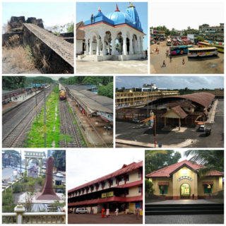
Kanhangad is a major town, located in the Kasaragod District, state of Kerala, India.
Nileshwaram or Nileshwar or Neeleswaram is a municipality and a major town in Kasaragod District, state of Kerala, India. It is one of the three municipalities in Kasaragod district; the others are Kasaragod and Kanhangad. Nileshwaram is located on the estuary of Kavvayi Backwaters and Neeleshwaram River. Nileshwaram is referred to as the cultural capital of Kasaragod, the northernmost district of Kerala. "The first Chief Minister of Kerala and communist leader E. M. S. Namboodiripad had contested elections to the Assembly from the Neeleswaram segment."

Bekal is a small town in the Kasaragod district on the West coast of the state of Kerala, India.
Ajanur is a grama panchayat and also a village of the same name in Kasargode district, Kerala state, India. It is the fifth largest town in Kasaragod district.

Udma is a census town in Kasaragod district in the Indian state of Kerala.
Koyonkara is a small village situated in Trikarpur Panchayath of Kasaragod district, Kerala, India. It constitutes the main part of North Trikarpur Village.

Uppala is a town and Headquarters of Manjeshwaram Taluk in Kasaragod district, Kerala, India. It is geographically located midway from Kasaragod to Mangalore. Easy geographical access and lack of major towns nearby are the key reasons for the town to develop exponentially, especially in the past decade. The population of Manjeshwaram Taluk alone was over 268,642 as of 2011. Uppala is 22 km north of Kasaragod and one of the fastest growing urban settlements in Kasaragod district. It is well known as an important trade hub in the northernmost part of Kerala state.
Athinhal is a coastal village in Kasaragod district in the Indian state of Kerala. It is 28 km from the district capital of Kasaragod and one kilometer north of Kanhangad.

Thirumeni is a village in Kannur district in the Kerala state of India. It is known for its hill station Chathamangalam Hills. The village has several recently migrated families from various parts of the erstwhile political entity (state) of Travancore who settled here in the famed "Malabar migration period" in the nineteenth century. Most of the inhabitants of the village reside in the valley of three major hills by name Chathamangalam Theruvamala alias Alumbumala, Kottathalachimala and Thevarkunnumala. Thirumeni is a small junction with a few government institutions, religious institutions and small shops in int. and is subdivided into smaller villages like Kokkadave, Prapoyil, Chathamangalam (Kannur), Thabore, Muthuvom, Korali, Chattivayal, Thannichal, Paruthikallu etc.
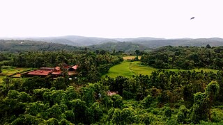
Maloth (also known as malom) is a village in Kasaragod district of the state of Kerala., Maloth is a village in Western Ghats. It is situated in the Balal Panchayath of Kasaragod District of Kerala. It is a part of the Kasaragod Parliament constituency. Earlier it was in the Hosdurg assembly constituency which is renamed as Kanhangad after the delimitation of assembly constituencies in 2011. It shares borders with the Karnataka forest. Nearest towns are Kanhangad, Cherupuzha, and Nileshwaram. One can reach Maloth through bus from Kanhangad or from Cherupuzha. Private as well as KSRTC buses playing between Kanhangad and Konnakkad passes through the village.
Panayal is a village in Kasaragod district in the state of Kerala, India. It is situated approximately 6 km inland from the coastal town of Bekal. Panayal is 18.3 km by road from Kasaragod and around 14.9 km from Kanhangad. Sri Mahalingeshwara Aided Upper Primary School and the Sri Mahalingeshwara Shiva temple are located here. Panayal is known for the Theyyam art form performed in the many family shrines in the area.
Periya is a small township in Kasaragod District, Kerala State, India.
Kodoth is a village in the Kasaragod district of Kerala, India.
Arangadi is a village in the kanhangad municipality of the Kasaragod district in the Indian state of Kerala. Arangadi is also known as Sithasook. It is 3 km from Kanhangad. Arangadi is a predominantly Muslim area of Kanhangad.People call also iron fort of muslim league
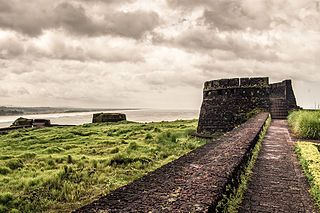
Pallikkara is a census town and a grama panchayat in Hosdurg Taluk of Kasargod district in the state of Kerala, India. This place was once famous for its Tobacco plants until the late 1980s and the Historical landmark Bekal Fort lies in this Village. A beach park near to the fort also attracts tourists to this place.
Kanhangad south is a village in Kanhangad municipality in Kasargod district in the Indian state of Kerala. It has a low population and the river Arayi flows near to this beautiful place.

Vellarikund is a town and taluk headquarters in the Hill range of Kasaragod District in the state of Kerala. Vellarikundu is located between Odayanchal and Chittarikkal on Odayanchal-Cherupuzha Road.
Periyanganam is a village in Karindalam panchayathu in Kasaragod District in the Indian state of Kerala. Neighbouring places are Kolamkulam and other side is Kumbalappally, and on opposite sides are Palanthadam and Mayyanganam. The nearest city is Nileshwar 20 km away.
Podippalam is a village in Kasaragod district in the state of Kerala, India.

Mulleria is a small town located in Karadka Panchayath, Kasaragod district in Kerala, India.
