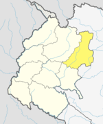
Bajura District, a part of Sudurpashchim Province, is one of the seventy-seven districts of Nepal. The district, with Martadi as its district headquarters, covers an area of 2,188 km2 (845 sq mi) and had a population of 108,781 in 2001 and 134,912 in 2011.

Darchula District is one of the nine districts of Sudurpashchim Province. The area, with Khalanga as its capital, covers an area of 2,322 km2 (897 sq mi) and has a population (2011) of 133,274. Darchula lies in the west-north corner of the country.
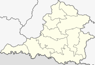
Siraha District, a district in Madhesh Province, is one of the seventy-seven districts of Nepal. It is situated in the Terai belt of Nepal. The district, with Siraha as its district headquarters, covers an area of 1,188 km2 (459 sq mi). It has population of 637,328 according to census of 2011.The District is bordered with Saptari district in the east, Udayapur districting the north, Bihar state of India in the south and Dhanusa district in the west. Majority of the population here is yadav, Kushwaha(mahato),Tharus, Sahs(sahukar), Muslims and ethnic minorities with majority population speaking English, Maithili language and Nēpālī language.

Kurseong is a town and a municipality in Darjeeling district in the Indian state of West Bengal. It is the headquarters of the Kurseong subdivision.

Inaruwa is the headquarter of Sunsari district that lies in the Koshi province of Eastern Nepal. Inaruwa is a municipality since the time of Panchayat in the year 2047 BS. After 2015, it has been operating under a mayor-council form of government and is currently led by Mayor Kedar Bhandari. Spanning 77.92 square kilometers, the municipality is home to a population of nearly 75 thousand residents.

Triyuga is one of the eight municipalities of Udayapur district of the Koshi Pradesh of Nepal. Gaighat is the headquarter of the municipality. According to the 2021 Nepal census the total population of the municipality is 103,475. It is divided into 16 wards. Triyuga Municipality was established on B.S. Chaitra 13, 2053. It was named after Triyuga River. A river which flows through the town. Triyuga is the 3rd largest municipality in Nepal and 1st largest in Koshi Pradesh in term of size (area). The total area of the municipality is 547.43 square kilometres (211.36 sq mi)
Waling Municipality, located in the heart of Syangja, is a town and municipality in the western hilly region of [[Nepal]. It was formed on 24 January 1997 by the merging of the then three VDCs namely Waling, Dhanubase and Pekhubaaghkhor. Due to the restructuring of the local government as part of the Federal Government System on 10 March 2017, the municipality's area was expanded to include Majhakot Shiwalaye VDC, Eladi VDC, Jagat Bhanjyang VDC, Chhangchhangdi VDC, Malyangkot VDC, Tindobate VDC, Kalikakot VDC Pelakot VDC ,Thumpokhara VDC(Ward No. 13,14) and Sworek VDC. It is located in the Aadhikhola valley and is bisected by the historic Andhikhola River in Syangja District, Gandaki Province of Nepal. Waling is named the Pink City due to its practice of painting local houses pink. The Government of Nepal has recognized Waling as one of the cities with the potential for future development under the Smart City initiative. Waling received an award for the best municipality of the country and was declared the Clean City of Nepal for The fiscal year 2017.
Siraha is the headquarters and municipality of Siraha District, a part of Madhesh Province, Nepal. Siraha had a population of 28,442 according to the census of 2011. and a population of 82,531 as of 2015. The current population of Siraha municipality as of census 2022, is 96,543. It has a male population of 47,306 and female population of 49,237. The present mayor of Siraha Municipality is Dr. Nabin Kumar Yadav and Deputy Mayor is Babita Kumari Sah. Both assumed office on 25 May 2022. His predecessor mayor was Asheswor Yadav and the deputy mayor was Dr. Namita Yadav. Both assumed office on 25 September 2017 and their last working day was on 24 May 2022. The town is at 80 metres (260 ft) altitude, 29 kilometres (18 mi) ESE of Janakpur.

Bahrabise is an urban municipality located in Sindhupalchok District of Bagmati Province of Nepal.
Melamchi is a municipality in Sindhupalchok District in the Bagmati Province of central Nepal. At the time of the 1991 Nepal census, it had a population of 3,936 and had 710 houses in the village.
Budhiganga Municipality is the newly formed municipality in Bajura District in the Sudurpashchim Province of Nepal. It was formed in March, 2017 as decided by the Cabinet in line with the Constitution of Nepal 2015, recommended by the Local Bodies Restructuring Commission (LBRC).
Kailashmandau used to be VDC in Bajura District in the Seti Zone of north-western Nepal. At the time of the 2011 Nepal census it had a population of 9,586 and had 1818 houses. There is a small market and it is also the junction to many villages of this region.
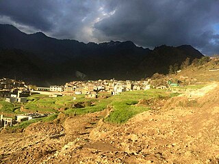
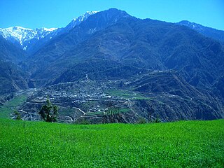
Martadi is a town and seat of Bajura District Coordination Committee. It is also the headquarters of the Badi Malika Municipality. At the time of the 1991 Nepal census it had a population of 4,618 and had 942 houses in the town but now it has increased by growth rate of 2.62 and reached 8807.
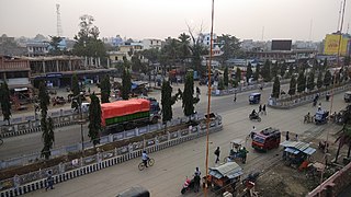
Kathauna Bazar is a city in Shambhunath Municipality Ward No. 6, in the Saptari district of Nepal. It is 20 km east of Lahan Municipality, and is the central city of Shambhunath Municipality. Shambhunath municipality's head office is located at Kathauna Bazar. At the time of the 1991 Nepal census it had a population of 5167 people, living in 933 individual households.
Mahakali, formerly Dodhara-Chandani, is a municipality in the Kanchanpur District of Sudurpashchim Province, in Nepal.

Gokarneshwor is a municipality in Kathmandu District in the Bagmati Province of Nepal that was established on 2 December 2014 by merging the former Village development committees Sundarijal, Nayapati, Baluwa, Jorpati and Gokarna. The office of the municipality is that of the former Jorpati village development committee. The river Bagmati has its origin as the name Bagh Dwar situated in the middle of the Shivapuri jungle in this municipality.

Madhesh Province is a province of Nepal in the Terai region with an area of 9,661 km2 (3,730 sq mi) covering about 6.5% of the country's total area. It has a population of 6,126,288 as per the 2021 Nepal census, making it Nepal's most densely populated province and the smallest province by area. It borders Koshi Pradesh to the east and the north, Bagmati Province to the north, and India’s Bihar state to the south and the west. The border between Chitwan National Park and Parsa National Park acts as the provincial boundary in the west, and the Kosi River forms the provincial border in the east. The province includes eight districts, from Parsa in the west to Saptari in the east.
Budhinanda Municipality is the newly formed municipality in Bajura District in the Sudurpashchim Province of Nepal. It was formed in March 2017 in line with the Constitution of Nepal 2015 as per the requirement of Ministry of Federal Affairs and General Administration. The name of this municipality is originated after the name of temple and pound Budhinanda.

Triveni is a municipality in Bajura district in the Sudurpashchim Province of Nepal. It was formed in March 2017 as decided by the Cabinet in line with the Constitution of Nepal 2015, recommended by the Local Bodies Restructuring Commission (LBRC).
Himali is a rural municipality in Bajura District in the Sudurpashchim Province of Nepal. It was formed in March 2017, when Government of Nepal announced 744 local level units in line with the Constitution of Nepal 2015. It lies in the northern region of Bajura District and is also considered to be the remote place of this district.