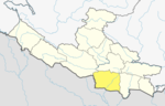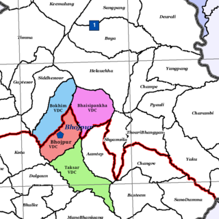
Bhaisipankha is a former VDC and now a neighborhood of Bhojpur Municipality in Bhojpur District in the Province No. 1 of eastern Nepal. At the time of the 1991 Nepal census it had a population of 3,077 persons living in 555 individual households.
Bokhim is a former VDC and now a neighborhood of Bhojpur Municipality in Bhojpur District in the Province No. 1 of eastern Nepal. At the time of the 1991 Nepal census it had a population of 3438 persons living in 618 individual households.
Sangrumba साङरुम्बा is a town and Village Development Committee in Ilam District in the Province No. 1 of eastern Nepal. At the time of the 1991 Nepal census it had a population of 4,607 persons living in 839 individual households. According to the VDC report of 2068 BS, the total population was 6,288 and the total number of households was 1,227, an average of 5.12 members per household.
Amarpatti is a village and Village Development Committee in Bara District in the Narayani Zone of south-eastern Nepal. At the time of the 2011 Nepal census it had a population of 3,738 people living in 508 individual households. There were 1,874 males and 1,864 females at the time of census.
Beldari is a village and Village Development Committee in Bara District in the Narayani Zone of south-eastern Nepal. At the time of the 1991 Nepal census it had a population of 2,836 persons living in 466 individual households.
Benauli is a town and Village Development Committee in Bara District in the Narayani Zone of south-eastern Nepal. At the time of the 1991 Nepal census it had a population of 5110 persons living in 659 individual households.

Nijgadh, is a town and municipality in Nepal, located in Bara District of the Madhesh Province. The total area of the municipality is 289.4 sq. km. The municipality was formed on 8 May 2014 by merging Nijgadh VDC with Ratnapuri VDC and Bharatganj Singaul VDC.
Gadhawa (Gadawa) is a village in the Gadhawa Rural Municipality of Dang Deukhuri District in Lumbini Province, south-western Nepal. It was, prior to September 2015, also a Village Development Committee in Dang Deukhuri District, Rapti Zone. At the time of the 2011 Nepal census the VDC had a population of 11,430 persons living in 2,176 households, up from the 2001 Nepal census of 7,877 persons living in 1,188 households.
Saudiyar is a town and Village Development Committee in Dang Deokhuri District in Lumbini Province of south-western Nepal. At the time of the 1991 Nepal census it had a population of 8,052 persons living in 1067 individual households.
Dhikurpokhari is a suburb and former Village Development Committee in Kaski District in the Gandaki Province of northern-central Nepal. At the time of the 1991 Nepal census it had a population of 7,392 persons living in 1,427 individual households.
Barangja is a village development committee in Myagdi District in the Dhaulagiri Zone of western-central Nepal. At the time of the 1991 Nepal census it had a population of 4576 people living in 891 individual households.
Chapakot is a municipality in the southeastern part of Syangja District in Gandaki Province of central Nepal. The new municipality was formed by merging three existing villages—Ratnapur, Kuwakot and Chapakot—on 18 May 2014. In 12 March 2017 The government implemented the new local administrative structure consisting of 744 local units. With the implementation of this new local administrative structure, the old structure will no longer be in existence. According to the new structure, VDCs will be replaced with village councils. Newly merged VDCs are Sankhar, Sekham, Ward no. 8 of Pakbadi & Ward no. of Malyangkot. The office of the municipality is that of the former Chapakot Municipality.
Bangai is a village development committee in Kapilvastu District in the Lumbini Zone of southern Nepal. Locally, there are two places known by the name of Bangai, Gherawa Bangain in the east and Koili Bangain in the west, separated by the distance of 1 km. Mahendra Highway or east–west highway passes through it. The Banganga river marks the south boundary of Bangain. Manoharipur is the first adjacent village in the south of it which lies in the Kopawa V.D.C. Locally, Bangain is famous for its funeral site on the bank of Banganga known as Laxmanghat. It is also a major shopping hub within 5 km of its radius due to its proximity with the highway. At the time of the 1991 Nepal census it had a population of 2983 people living in 528 individual households.
Shivanagar is a town in Krishnanagar Municipality in Kapilvastu District in the Lumbini Zone of southern Nepal. The former VDC was merged to form the municipality established on 18 May 2014 Krishnanagar, Sirsihawa, Shivanagar VDCs. At the time of the 2011 Nepal census it had a population of 4,774 people living in 735 individual households.
Hardauna is a village in the sub-metropolitan municipality of Maharajganj in the Kapilvastu District of the Lumbini Province. The village is in a terai region in southern Nepal. It is on the Banganga, a river which arises on the southern slopes of the Sivalik Hills and flows across the Terai, reaching into Uttar Pradesh state in India.
Pathari Shanishchare (पथरी-शनिश्चरे) is a Municipality in Morang District in the Koshi Zone of south-eastern Nepal. It was formed by merging three existing village development committees i.e. Hasandaha, Pathari and Sanischare in May 2014.
Kolhuwa is a village development committee in Nawalparasi District in the Lumbini Zone of southern Nepal. At the time of the 1991 Nepal census it had a population of 6,292 people living in 1,025 individual households. .This VDC was merged in the Madhyabindu municipality on 19 September 2015 along with Tamasariya and Narayani Village development committees (VDCs). The center of the municipality is established in the former Tamasariya VDC of Chormara Bazaar. After merging the three VDCs population it had a total population of 28,224 according to 2011 Nepal census.
Sundar Haraicha is a municipality in Morang District of Koshi Province in Nepal. It is centered around Biratchowk town which is the gateway to Biratnagar. It borders Itahari Sub- Metropolitan city to the West, Dharan Sub- Metropolitan city to the Northwest and Belbari municipality to the East and is connected by the Mahendra Highway. It is one of the fastest growing cities in the Eastern Nepal and the second largest city of Morang district after Biratnagar with 121,305 inhabitants living in 26,677 households. It consists the town centres of Biratchowk and Gothgaun which are parts of the Greater Birat Development Area which incorporates the cities of Biratnagar-Itahari-Gothgau-Biratchowk-Dharan primarily located on the Koshi Highway in Eastern Nepal, with an estimated total urban agglomerated population of 804,300 people living in 159,332 households.
Pacharauta is a municipality in Bara District in Province No. 2 of South-Eastern Nepal. It was formed in 2016 occupying current 9 sections (wards) from previous 9 former VDCs. It occupies an area of 44.01 km2 with a total population of 34,175.
Bhojpur is a neighborhood in Bhojpur Municipality which is located in Bhojpur District in Province No. 1 of Nepal. The Bhojpur Village Panchayat was established in 1962 and was renamed as Bhojpur Village development committee in 1990.