Pyuthan is a municipality in the Pyuthan District in the Lumbini Province of Nepal. This municipality is named after the district name Pyuthan. It is also the major market center and the administrative center of district. The municipality was established on 18 May 2014 by merging the existing VDCs Khaira, Dakha Kwadi, Bijaya Nagar, Bijuwar, Dharmawati, Maranthana and Khalanga village development committees. In 2017, when GoN restructured the local level bodies into 753 units, Pyuthan Municipality was also restructured excluding ward no. 1, 2, 3, 5 and 18 from old structure, further two other VDCs; Majhkot and Jumrikanda added, Khalanga separated and managed the municipality into 10 new wards. Nayabajar Jumri and Bijuwar are the major markets of Pyuthan Municipality.
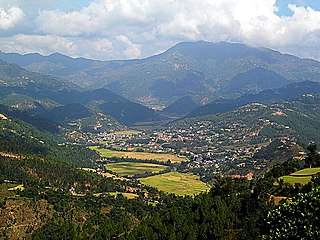
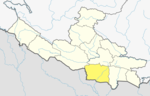
Sandhikharka Municipality is the headquarter of Arghakhanchi District which lies in Lumbini Province of Nepal. The former village development committee (VDC) was converted into a municipality on 18 May 2014 by merging the existing Sandhikharka, Wangla, Narapani, Khanchikot, Kimadada, Argha and Dibharna VDCs. It is located, in a valley surrounded by hills, in the western part of the capital, Kathmandu.
Wangla is a Market Center in Sandhikharka Municipality of Arghakhanchi District in the Lumbini Zone of southern Nepal. The former village development committee (VDC) was converted into a municipality on 18 May 2014 by merging the existing Sandhikharka, Wangla, Narapani, Khanchikot, Keemadada, Argha and Dibharna VDCs. At the 1991 Nepal census, the town had a population of 5,142 living in 1,033 houses. At the 2001 Nepal census, the population was 5,380, of which 66% was literate.
Kimadanda is a market center in Sandhikharka Municipality of Arghakhanchi District in the Lumbini Zone of Western Nepal. The former village development committee (VDC) was converted into a municipality on 18 May 2014 by merging the existing Sandhikharka, Bangla, Narapani, Khanchikot, Kimadada, Argha and Dibharna VDCs. At the 1991 Nepal census, the town had a population of 5,430 living in 1,085 houses. At the 2001 Nepal census, the population was 3,514, of which 53% was literate.
Khanchikot is a market center in Sandhikharka Municipality of Arghakhanchi District. The district lies in the Lumbini Zone of Western Nepal. The former village development committee (VDC) was converted into a municipality on 18 May 2014 by merging the existing Sandhikharka, Bangla, Narapani, Khanchikot, Keemadada, Argha and Dibharna VDCs. At the 1991 Nepal census it had a population of 4,628 individuals and had 930 houses.
Mahat Gaun is a market center in Chandannath Municipality in Jumla District in the Karnali Zone of north-western Nepal. The formerly village development committee was merged with Mahat Gaun, Talium, Kartik Swami, Chandannath village development committees to form the new municipality. At the time of the 1991 Nepal census it had a population of 2501 persons living in 496 individual households.
Bijuwar is a town and market center in Pyuthan Municipality in Pyuthan, a Middle Hills district of Rapti Zone, western Nepal. The former Village Development Committee along with Pyuthan Khalanga, Bijubar, Dakha Kwadi, Bijaya Nagar, Dharmawati, Maranthana and Khaira were merged to form the new municipality since 18 May 2014. Bijuwar is the main commercial center in the valley of Jhimruk Khola.
Ishworpur is a Municipality in Sarlahi District in the Janakpur Zone of south-eastern Nepal. The municipality was established on 18 May 2014 by merging the existing Bela, Bhaktipur, Gaurishankar and Ishwarpur VDCs. At the time of the 1991 Nepal census it had a population of 14,014 people living in 249 individual households.
Khalanga is market center in Sharada Municipality in Salyan District of Karnali Province of Nepal. The place formerly existing as Village Development Committee was annexed to form a new municipality since 18 May 2014. It is the district headquarter of Salyan District. At the time of the 1991 Nepal census it had a population of 6380.
Saijuwal Takura is market center in Sharada Municipality in Salyan District in the Rapti Zone of western-central Nepal. The place formerly existing as Village Development Committee was annexed to form a new municipality since 18 May 2014. At the time of the 1991 Nepal census it had a population of 3,137 living in 593 individual households.

Musikot is a municipality and the district headquarter of Western Rukum District in Karnali Province of Nepal that was established as Musikot Khalanga on 2 December 2014 by merging the two former Village development committees Musikot and Khalanga. From 2014 until 2018, Musikot was called Musikot Khalanga and until 2017 served as the district headquarter of Rukum District. It lies on the bank of Sani Bheri River. It borders with Eastern Rukum in the east, Sanibheri rural municipality in the west, Banfikot rural municipality in the north and Tribeni rural municipality and Rolpa district in the south.
Khaliban is a town in Rampur Municipality in Palpa District in the Lumbini Zone of southern Nepal. The municipality was established on 18 May 2014 by merging the existing Gadakot, Gegha, Khaliban, Darchha village development committee. At the time of the 1991 Nepal census it had a population of 2272 people living in 399 individual households.
Madanpokhara is a village development committee in Palpa District in the Lumbini Zone of southern Nepal. At the time of the 1991 Nepal census it had a population of 6269 people living in 1148 individual households.
Birpur is a town in Shivaraj Municipality in Kapilvastu District in the Lumbini Zone of southern Nepal. The former village development committee was transformed into Municipality from 18 May 2014 by merging the existing Birpur, Nepal, Chanai, Bishunpur, Jawabhari and Shivapur village development committees. At the time of the 2001 Nepal census it had a population of 15255 people living in 1209 individual households.
Bishunpur is a town in Shivaraj Municipality in Kapilvastu District in the Lumbini Zone of southern Nepal. The former village development committee was transformed into a Municipality from 18 May 2014 by merging the existing Birpur, Nepal, Chanai, Bishunpur, Jawabhari and Shivapur village development committees. At the time of the 1991 Nepal census it had a population of 2942 people living in 472 individual households.
Chanai is a town in Shivaraj Municipality in Kapilvastu District in the Lumbini Zone of southern Nepal. The former village development committee was transformed into Municipality from 18 May 2014 by merging the existing Birpur, Nepal, Chanai, Bishunpur, Jawabhari and Shivapur village development committees. At the time of the 1991 Nepal census it had a population of 6141 people living in 1023 individual households.
Shivanagar is a town in Krishnanagar Municipality in Kapilvastu District in the Lumbini Zone of southern Nepal. The former VDC was merged to form the municipality established on 18 May 2014 Krishnanagar, Sirsihawa, Shivanagar VDCs. At the time of the 2011 Nepal census it had a population of 4,774 people living in 735 individual households.
Jawabhari is a town in Shivaraj Municipality in Kapilvastu District in the Lumbini Zone of southern Nepal. The former village development committee was transformed into Municipality from 18 May 2014 by merging the existing Birpur, Nepal, Chanai, Bishunpur, Jawabhari and Shivapur village development committees. At the time of the 1991 Nepal census it had a population of 2147 people living in 346 individual households.
Mukundapur is a town in Gaidakot Municipality in eastern part of Nawalparasi District in the Lumbini Zone of southern Nepal. It became a municipality in May 2014 by merging the existing Mukundapur, Amarapuri, Gaidakot, Nawalparasi, VDCs. At the time of the 1991 Nepal census it had a population of 7631. According to the 2011 Nepal census, the VDC had a population of 13,027 living in 3,023 houses. The VDC is historically important as the "Mukundasen Palace" built by King Madimukundasen of Palpa lies here. The VDC is named after this Palace.

Lumbini Sanskritik is a municipality situated in Rupandehi District of Lumbini Province in Nepal. Lumbini, the Buddhist pilgrimage site where Buddha was born lies in the center of this municipality.
It lies at the western part of the Nepal and it is crossed over by the east west highway. It lies in 5 no. State at Lumbini zone .
Shivaraj municipality, Buddhabhumi municipality and the districts and municipality including Taulihawa are densely populated.