
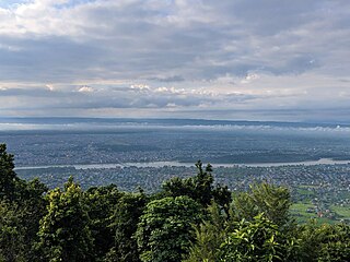
Pokhara is a metropolitan city located in central Nepal, which serves as the capital of Gandaki Province and is declared as the tourism capital of Nepal. It is the second most populous city of the nation after Kathmandu, with 599,504 inhabitants living in 120,594 households as of 2021. It is the country's largest metropolitan city in terms of area. The city also serves as the headquarters of Kaski District. Pokhara is located 200 kilometres west of the capital, Kathmandu. The city is on the shore of Phewa Lake, and sits at an average elevation of approximately 822 m above sea level. The Annapurna Range, with three out of the ten highest peaks in the world—Dhaulagiri, Annapurna I and Manaslu—is within 15–35 mi (24–56 km) aerial range from the valley.

Chitwan District is one of 77 districts of Nepal, and takes up the southwestern corner of Bagmati Province. Bharatpur, largest city of Nepal after Kathmandu, is its administrative centre. It covers 2,238.39 km2 (864.25 sq mi), and in 2011 had a population of 579,984 people. Bharatpur is the commercial and service centre of South Central Nepal and a major destination for higher education, health care and transportation in the region. Chitwan lies in the Terai region of Nepal. It is in the drainage basin of the Gandaki River and is roughly triangular, taking that river as its meandering northwestern border, and a modest watershed border, with India, as the basis of its southern limit. Local government: Bharatpur Metropolitan, Rapti Municipality, Ratnanagar Municipality, Kalika Municipality, Khairahani Municipality, Madi Municipality, Ikshyakamana Gaupalika

Birgunj is a metropolitan city in Parsa District in Madhes Pradesh in southern Nepal. It lies 135 km (84 mi) south of the capital Kathmandu, attached in the north to Raxaul on the border of the Indian state of Bihar. As an entry point to Nepal from Patna, Birganj is known as the "Gateway of Nepal". It is also called the "Commercial Capital of Nepal". The town has significant economic importance for Nepal as most of the trade with India is via Birganj and the Indian town of Raxaul. The Tribhuvan Highway links Birgunj to Nepal's capital, Kathmandu.
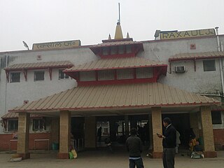
Raxaul is a sub-divisional town in the East Champaran district of the Indian state of Bihar. It is situated at the India-Nepal border with Birgunj city (Nepal). Raxaul is a major railway junction.

Butwal, officially Butwal Sub-Metropolitan City ,previously known as Khasyauli, is a sub-metropolitan city and economic hub in Lumbini Province in West Nepal. Butwal has a city population of 195,054 as per the 2021 AD Nepal census.
Bharatpur is a city in south central Nepal. It is the third most populous city of Nepal after Kathmandu and Pokhara with 369,377 inhabitants in 2021. It is also the second largest metropolitan city in Nepal by area. It is the district headquarter of the Chitwan District.

Devghat is one of the famous religious and cultural centers in central Nepal. At the time of the 1991 Nepal census it had a population of 5,786 people living in 1,132 individual households.
Kushma is a small village and the headquarter of Parbat District in Nepal. Kushma municipality was formed by merging thirteen village development committees Pang, Khurkot, Durlung, Shivalaya, Chuwa, Katuwa Chaupari, Pipaltari and Pakuwa on 18 May 2014.

By Any Means, also known as Ireland to Sydney by Any Means, is a television series following Long Way Round and Long Way Down TV presenter Charley Boorman. Travelling from Wicklow, Ireland, to Sydney, New South Wales, Australia, it features him completing the journey using 112 modes of transport and only travelling by plane when absolutely necessary.

Malangwa is a town, a municipality, and the headquarter of Sarlahi District in Madhesh Province of Nepal. The district's oldest municipality, it is in parliamentary constituency 2. From the Mahendra Highway 25 kilometres (16 mi) south of Nawalpur, a small highway side town. Situated at an altitude of 79 meters (259 ft) above sea level, Malangwa is near the Indian border at Sonbarsa. There is a customs checkpoint at the border crossing.
Dhusha, now Benighat Rorang is a Rural Municipality in Dhading District in the Bagmati Zone of central Nepal. At the time of the 1991 Nepal census it had a population of 6350. The Dhusha VDC office is located at Charaundi Bazar, which is one of the Commencing place of the White Water Rafting in Trishuli River which started longway back. The bazar is also the main business area for the whole VDC which is located along the Prithvi Highway. Like the general geographical status of the whole country, Dhusha rises from low altitude to medium - high altitude region. Charaundi Khola, flows very close to the bazar.
Raipur (राइपुर) is part of Shuklagandaki Municipality in Tanahu District of Gandaki Province [Province No. 4], in central Nepal. The whole previous Raipur Village Development Committee is now included as the Ward No 11 of Shuklagandaki Municipality in March 2017. The head of the Raipur Ward No 11 is Shalikram Bhattarai. According to the Population Census of 1991, it had a population of 4581 people living in 850 individual households. Raipur is situated in about 18 km west from Dulegaunda Town & about 15 km from Putalibazar of Syangja District. From this village Of the top part called Raipurkot, we can have a panoramic view of Annapurna and Dhaulagiri Macchapuchre Range in the north, green hills, fertile land in the river banks, terraces and many others places with seasonal fruits and vegetables. The lifestyle of people living in Raipur is simple, and the majority of them are farmers. Most of the people from Raipur are migrated to Dulegaunda, Belchautara, Dhorfridi, Pokhara, Syangja, Chitwan, Kathmandu and other urban areas. About 90% of youths of Raipur are at Third Countries and Gulf for unskilled and low skilled employments.. Recently the village is connected with the national grid of electricity network. Not all the areas of Raipur has good drinking water facilities. People, in the hillside such as Bishauna, Chilaunekhark, Baaspani (Gaunpahal), Thumkidada, Simleshwara, Samtari, Bangalekhola have to spend most of their morning time in collecting drinking water from pond.
Gamhariya was a village development committee in Rautahat District in the Narayani Zone of south-eastern Nepal.
Jagatpur is a small town of Bharatpur Metropolitan City and former village development committee in Chitwan District, Bagmati Province of Nepal. At the time of the 2011 Nepal census it had a population of 11,195 people living in 2,635 individual households.
Meghauli is a small city and former Village Development Committee that is now part of Bharatpur Metropolitan City in Bagmati Province of central Nepal.
Rajghat is a small village in the Urlabari Municipality, comprising two wards; 8 and 9 in the Morang District in the Koshi Zone of south-eastern Nepal. It is located in North-East part of Morang and 1.5 kilometers south of the East West national highway of Nepal. Durgapuri Bazar is the local town of Rajghat. This place is one of the major habitat of indigenous Dhimal, Santhal,and Mushahar communities.

Maula Kalika is a famous Hindu temple of Goddess Kalika in Gaindakot town of Nawalpur district in Gandaki province of Nepal. Located on the top of the Mauladada or Maula hill on the north of Narayani River in Gaindakot, Maula Kalika temple is situated 561 metres (1,841 ft) above sea level.

Inani Beach, part of Cox's Bazar Beach, is an 18-kilometre-long (11 mi) sea beach in Ukhia Upazila of Cox's Bazar District, Bangladesh. It has a lot of coral stones, which are very sharp. These coral stones look black and green, and they are found in summer or rainy seasons.
Gaindakot is a municipality in Nawalpur District in the Gandaki Zone of southern Nepal. It became a municipality in May 2014 by merging the existing Mukundapur, Amarapuri, and Gaindakot VDCs. It was again expanded by merging Ratanpur VDC. It is situated on the shore of Narayani River in the lap of Maula Kalika temple. So this place has a great possibility of tourism development. At the time of the 2011 Nepal census, it had a population of 58,841 and 13,623 individual households according to 2011 Nepal census.
Dhusha is a village Development Committee in Dhading District in the Bagmati Zone of central Nepal. At the time of the 2011 Nepal census it had a population of 7190. The Dhusha VDC office is located at Charaundi Bazar, which is one of the Commencing place of the White Water Rafting in Trishuli River which started longway back. The bazar is also the main business area for the whole VDC which is located along the Prithvi Highway. Like the general geographical status of the whole country, Dhusha rises from low altitude to medium - high altitude region. Charaundi Khola, flows very close to the bazar.


