Kalika, Chitwan

Last updated
Kalika municipality
कालिका tempol [का.न.पा.]
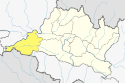
Nepal Bagmati adm location map.svg
Red pog.svg
Kalika municipality
Location in Nepal
Nepal adm location map.svg
Red pog.svg
Kalika municipality
Kalika municipality (Nepal)
Coordinates: 27°41′35″N84°34′19″E / 27.693°N 84.572°E / 27.693; 84.572
CountryFlag of Nepal.svg    Nepal
Province Bagmati Province
District Chitwan District
Government
   Mayor Mr.Binod Regmi (विनोद रेग्मी) (NCP)
   Deputy Mayor Mrs.Bimala Tamang (विमला तामाङ) (NCP)
   Executive Officer Mr. Chudamani Sharma Gautam
Population
 (1991)
  Total28,611
Time zone UTC+5:45 (NST)
Website kalikamun.gov.np

Kalika is a municipality in Chitwan District in the Narayani Zone of southern Nepal. This municipality was established in 2015 AD by merging the existing Jutpani, Padampur, Shaktikhor and Siddhi VDCs. [1] [2]

Contents

Etymology

History

Geography

Demographics

According to the results of National Census 2078, the total population is 52,164 (females 26,656 and males 25,508) and the number of households is 12,258.

At the time of the 2011 Nepal census, Kalika Municipality had a population of 44,898. Of these, 60.1% spoke Nepali, 12.3% Chepang, 12.1% Tharu, 10.4% Tamang, 1.3% Magar, 0.8% Maithili, 0.7% Gurung, 0.7% Newar, 0.6% Bote, 0.3% Bhojpuri, 0.2% Darai, 0.1% Ghale and 0.1% other languages as their first language. [3]

In terms of ethnicity/caste, 17.7% were Hill Brahmin, 17.5% Chepang/Praja, 16.1% Tamang, 12.5% Tharu, 9.0% Chhetri, 5.3% Newar, 4.4% Magar, 4.1% Gurung, 3.1% Kami, 2.9% Kumal, 1.8% Damai/Dholi, 0.9% Bote, 0.8% Koiri/Kushwaha, 0.8% Sanyasi/Dasnami, 0.4% Gharti/Bhujel, 0.3% Darai, 0.3% Sarki, 0.3% Sunuwar, 0.3% Thakuri, 0.2% Ghale, 0.2% Musalman, 0.2% Rai, 0.1% Kayastha, 0.1% Majhi, 0.1% Sherpa, 0.1% Sonar and 0.2% others. [4]

In terms of religion, 70.1% were Hindu, 18.1% Buddhist, 9.2% Christian, 0.4% Prakriti, 0.2% Muslim, and 1.9% others. [5]

Education

Schools

Health care

Economy

Agriculture

Industries

Tourism Area

Sports

Religious Places

Science and Technology

Notable People

Major Places

Culture

Related Research Articles

<span class="mw-page-title-main">Dhading District</span> District in Bagmati Province, Nepal

Dhading District, a part of Bagmati Province, is one of the seventy-seven districts of Nepal. The district, with Dhading Besi as its district headquarters, covers an area of 1,926 square kilometres (744 sq mi), had a population of 338,658 in 2001 and 336,067 in 2011.

<span class="mw-page-title-main">Tanahun District</span> District in Gandaki Province, Nepal

Tanahun District, a part of Gandaki Province, is one of the seventy-seven districts of Nepal. The district lies in central Nepal, with Damauli as its district headquarters. It covers an area of 1,546 km2 (597 sq mi) and has a population (2011) of 323,288. Previously the town of Bandipur was its district headquarter. The postal code of Tanahun is 33900.

<span class="mw-page-title-main">Bharatpur, Nepal</span> Metropolitan City in Bagmati Province, Nepal

Bharatpur is a city in southern central Nepal. It is the third most populous city of Nepal after Kathmandu and Pokhara with 369,377 inhabitants in 2021. It is also the second largest metropolitan city in Nepal by area. It is the district headquarter of the Chitwan District.

<span class="mw-page-title-main">Gorkha Municipality</span> Municipality in Gandaki Province, Nepal

Gorkha is a municipality in Gorkha District in Gandaki Province of Nepal created in 1996. It was initially named "Prithibinarayan" after King Prithvi Narayan Shah, who was born in Gorkha and united and founded modern Nepal. In 2009, the name was changed to "Gorkha" municipality after the end of the monarchy in Nepal. At the time of the 2021 Nepal census it had a population of 53,285 people living in 12,641 individual households. In 2014, the neighboring Village development committees Nareshwar and Phinam were merged into the municipality.

Thakre is a Gaupalika(Nepali: गाउपालिका ; gaupalika)(Formerly: village development committee) in Dhading District. The local body was formed by merging four VDCs namely Bhumesthan, Tasarphu, Thakre, Kebalpur and Goganpani, Bagmati. It has eleven wards. The population was 32,914, according to data collected in the 2017 Nepalese local elections.

Ratnanagar is a municipality in Chitwan District of Bagmati Province in Nepal. It is the second biggest municipality after Bharatpur Metropolitan City that was formed in 1997 through the merger of the former Village Development Committees Old-Ratnanagar and Panchakanya. It is adjacent to Chitwan National Park, and serves as a gateway to the park. Agricultural products produced from Ratnanagar includes rice, maize, mustard and vegetables. This municipality is also a major place for production of poultry products and animal husbandry. Tourism is another source of income generation for the people in Ratnanagar. People are directly or indirectly dependent in tourism industry. Ratnanagar is also concerned in environment preservation so in order to preserve and protect environment, eco-friendly electric risk-shaw has also been introduced and available in different parts of this municipality. It lies on the bank of East Rapti River.

<span class="mw-page-title-main">Vyas Municipality</span> Municipality in Gandaki Province, Nepal

Vyas (Byas), is a municipality of Tanahun District located in Gandaki Province in Nepal and incorporates the village Damauli, the district headquarters, for which the municipality is also often referred to as Damauli. The municipality was established by merging the former Village development committee Damauli with several of its neighbors, the most recent merger being the one with Pokhari Bhanjyang in 2014. It lies on the bank of Madi Khola.

Manahari is a Rural Municipality in Makwanpur District in the Bagmati Province of Nepal. At the time of the 1991 Nepal census it had a population of 10,013 people living in 1789 individual households.

Madi is a municipality in Chitwan District of Nepal. With the population about 50,000, it is the fifth municipality in the district. Former four village development committee serially from East to West Ayodhyapuri (अयोध्यापुरी), Kalyanpur (कल्याणपुर), Baghauda (बघौडा) and Gardi (गर्दी) are politically merged to form Madi municipality. Geologically, Madi is a valley with north facing Churevabar and remaining surrounded with Shomeshowar Mountain. It is known for several ancient religious sites. Pandavas were here in their 12 years exile. There is a village named after them, Pandava Nagar in western Madi. This is also the sacred place for Hindus as the Saga Valmiki lived here thousands years ago.

<span class="mw-page-title-main">Tarakeshwar</span> Municipality in Bagmati Province, Nepal

Tarakeshwor " तारकेश्वर " is a municipality in Kathmandu District in Bagmati Province of Nepal that was established on 2 December 2014 by merging the former Village development committees Dharmasthali, Futung, Goldhunga, Jitpurphedi, Kavresthali, Manmaiju and Sangla. The office of the municipality is that of the former Dharmasthali village development committee.

Khairahani is a municipality in Chitwan District in Bagmati Province of southern Nepal. The municipality was established on 8 May 2014 by merging the existing Khairahani, Kumroj and Chainpur VDCs. At the time of the 1991 Nepal census it had a population of 13,629 people living in 2262 households.

Bansgadhi is a municipality in the Bardiya District in southwestern Nepal.

Rapti Municipality is a municipality which lies in Eastern part of Chitwan district in Bagmati Province of Nepal. It was formed as municipality in 2015 by merging five existing village development committees, Birendranagar VDC, Bhandara VDC, Piple VDC, Lothar VDC and Korak VDC. Total area of this municipality is 99.40 and population of this municipality according to 2068 BS census is 46510.

<span class="mw-page-title-main">Nawalpur District</span> District in Gandaki Province, Nepal

Nawalpur is one of 11 districts of Gandaki Province of Nepal. The headquarters of the district is Kawasoti.

<span class="mw-page-title-main">Sahid Lakhan Rural Municipality</span> Gaunpalika in Gandaki, Nepal

Sahid Lakhan Rural Municipality is a Gaunpalika in Gorkha District in Gandaki Province of Nepal. In 12 March 2017, the government of Nepal implemented a new local administrative structure, with the implementation of the new local administrative structure, VDCs have been replaced with municipal and Village Councils. Sahid Lakhan is one of these 753 local units.

Arughat Rural Municipality is a Gaunpalika in Gorkha District in Gandaki Province of Nepal. It is divided into 10 wards. On 12 March 2017, the government of Nepal implemented a new local administrative structure, with the implementation of the new local administrative structure, VDCs have been replaced with municipal and Village Councils. Arughat is one of these 753 local units.

Badhaiyatal is a rural municipality located in Bardiya District of Lumbini Province of Nepal.

Ichchhakamna is an only rural council located in Chitwan District in Bagmati Province of Nepal.

Benighat Rorang is a rural municipality located within the Dhading District of the Bagmati Province of Nepal. The rural municipality spans 29.17 square kilometres (11.26 sq mi), with a total population of 31,475 according to a 2011 Nepal census.

Devghat is a Rural municipality located within the Tanahun District of the Gandaki Province of Nepal. The rural municipality spans 159 square kilometres (61 sq mi) of area, with a total population of 16,131 according to a 2011 Nepal census.

References

  1. "Kalika (Municipality, Nepal) - Population Statistics, Charts, Map and Location". www.citypopulation.de. Retrieved 18 May 2019.
  2. "Voting re-scheduled in Kalika municipality-11 in Chitwan". The Himalayan Times. 11 May 2017. Retrieved 18 May 2019.
  3. NepalMap Language
  4. NepalMap Caste
  5. NepalMap Religion