
Birendra Bir Bikram Shah Dev, was the tenth King of Nepal from 1972 until his assassination in 2001. He was the eldest son of King Mahendra.

Narayani was one of the fourteen zones of Nepal until the restructuring of zones to Provinces, located in the central south of the country. The headquarter of Narayani zone was Hetauda. Narayani Zone is named after the Narayani River which is on the western border of the zone, separating it from the Gandaki and Lumbini zones. Narayani means beloved of Narayan which is Parvati his sister, and Narayan refers to Lord Vishnu in the Hindu religion.

Pokhara is a metropolitan city in central Nepal, which serves as the capital of Gandaki Province and the tourism capital of Nepal. It is the second most populous city of Nepal after Kathmandu, with 599,504 inhabitants living in 120,594 households in 2021. It is the country's largest metropolitan city in terms of area. The city also serves as the headquarters of Kaski District. Pokhara is located 200 kilometres west of the capital, Kathmandu. The city is on the shore of Phewa Lake, and sits at an elevation of approximately 822 m. The Annapurna Range, with three out of the ten highest peaks in the world—Dhaulagiri, Annapurna I and Manaslu—is within 15–35 mi (24–56 km) of the valley.

Buddha Air Pvt. Ltd is an airline based in Lalitpur, Nepal. It operates domestic flights within Nepal as well as international services to India, mainly Varanasi. Its main base is Tribhuvan International Airport, Kathmandu. It was the largest domestic carrier in terms of passengers carried in 2023.

Chitwan District is one of 77 districts of Nepal, and takes up the southwestern corner of Bagmati Province. Bharatpur, largest city of Nepal after Kathmandu, is its administrative centre. It covers 2,238.39 km2 (864.25 sq mi), and in 2011 had a population of 579,984 people. Bharatpur is the commercial and service centre of South Central Nepal and a major destination for higher education, health care and transportation in the region. Chitwan lies in the Terai region of Nepal. It is in the drainage basin of the Gandaki River and is roughly triangular, taking that river as its meandering northwestern border, and a modest watershed border, with India, as the basis of its southern limit. Local government: Bharatpur Metropolitan, Rapti Municipality, Ratnanagar Municipality, Kalika Municipality, Khairahani Municipality, Madi Municipality, Ikshyakamana Gaupalika

Birgunj is a metropolitan city in Parsa District in Madhes Pradesh in southern Nepal. It lies 135 km (84 mi) south of the capital Kathmandu, attached in the north to Raxaul on the border of the Indian state of Bihar. As an entry point to Nepal from Patna, Birganj is known as the "Gateway of Nepal". It is also called the "Commercial Capital of Nepal". The town has significant economic importance for Nepal as most of the trade with India is via Birganj and the Indian town of Raxaul. The Tribhuvan Highway links Birgunj to Nepal's capital, Kathmandu.

Butwal, officially Butwal Sub-Metropolitan City ,previously known as Khasyauli, is a sub-metropolitan city and economic hub in Lumbini Province in West Nepal. Butwal has a city population of 195,054 as per the 2021 AD Nepal census.
Bharatpur is a city in south central Nepal. It is the third most populous city of Nepal after Kathmandu and Pokhara with 369,377 inhabitants in 2021. It is also the second largest metropolitan city in Nepal by area. It is the district headquarter of the Chitwan District.

The Prithvi Highway or NH17 (Nepali: पृथ्वी राजमार्ग) is a 174-kilometre-long (108 mi) highway connecting Naubise of Tribhuvan Highway, 26 km from Kathmandu, the capital of Nepal, and Prithivi Chowk, Pokhara, a tourist city in the western part of Nepal.

Bharatpur Airport is a domestic airport located in Bharatpur serving Chitwan District, a district in Bagmati Province in Nepal. The airport is one of two airports in the vicinity of Bharatpur Metropolitan City, the other being Meghauli Airport. It serves as the main tourist gateway to Chitwan National Park.
Meghauli Airport is a domestic airport located in Meghauli, Bharatpur serving Chitwan National Park in Bagmati Province in Nepal. The airport is the older of two airports in Bharatpur, the other one being Bharatpur Airport.
Waling Municipality, the heart of Syangja, is a small valley covered with hills formed on 27 January 1997 by merging of the then three VDCs namely Waling, Dhanubase and Pekhubaaghkhor. It is a town and municipality in the western hilly region of Nepal. It is in the Aadhikhola valley in Syangja District, Gandaki Zone of Nepal. Waling will be the first municipality to have houses all coloured with pink and will be named as Pink City. Waling has grabbed an award for the best municipality of the country.

Mahendra Highway or NH01, also called East-West Highway, runs across the Terai geographical region of Nepal, from Mechinagar in the east to Bhim Datta in the west, cutting across the entire width of the country. It is the longest highway in Nepal and was constructed in cooperation with various countries. The highway is named after King Mahendra Shah.

Devghat is one of the famous religious and cultural centers in central Nepal. At the time of the 1991 Nepal census it had a population of 5,786 people living in 1,132 individual households.
The Chitwan Valley is an Inner Terai valley in the south of Nepal, encompassing the districts of Makwanpur, Chitwan and Nawalpur. The valley is part of the Terai-Duar savanna and grasslands ecoregion of about 150 km (93 mi) length and 30–48 km (19–30 mi) width.

Malangwa is a town, a municipality, and the headquarter of Sarlahi District in Madhesh Province of Nepal. The district's oldest municipality, it is in parliamentary constituency 2. From the Mahendra Highway 25 kilometres (16 mi) south of Nawalpur, a small highway side town. Situated at an altitude of 79 meters (259 ft) above sea level, Malangwa is near the Indian border at Sonbarsa. There is a customs checkpoint at the border crossing.
Meghauli is a small city and former Village Development Committee that is now part of Bharatpur Metropolitan City in Bagmati Province of central Nepal.

Sauraha is a village of Ratnanagar Municipality in Chitwan District and Chitwan Valley, in Bagmati Province of southern Nepal.

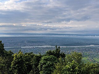
Maula Kalika is a famous Hindu temple of Goddess Kalika in Gaindakot town of Nawalpur district in Gandaki province of Nepal. Located on the top of the Mauladada or Maula hill on the north of Narayani River in Gaindakot, Maula Kalika temple is situated 561 metres (1,841 ft) above sea level.
Gaindakot is a municipality in Nawalpur District in the Gandaki Zone of southern Nepal. It became a municipality in May 2014 by merging the existing Mukundapur, Amarapuri, and Gaindakot VDCs. It was again expanded by merging Ratanpur VDC. It is situated on the shore of Narayani River in the lap of Maula Kalika temple. So this place has a great possibility of tourism development. At the time of the 2011 Nepal census, it had a population of 58,841 and 13,623 individual households according to 2011 Nepal census.

