Bajura District, a part of Sudurpashchim Province, is one of the seventy-seven districts of Nepal. The district, with Martadi as its district headquarters, covers an area of 2,188 km2 (845 sq mi) and had a population of 108,781 in 2001 and 134,912 in 2011.

Bahrabise is an urban municipality located in Sindhupalchok District of Bagmati Province of Nepal.
Dilasaini is a former village development committee that is now a Rural Municipality in Baitadi District in Sudurpashchim Province of western Nepal. At the time of the 1991 Nepal census it had a population of 4,828 and had 849 houses in the village. There is one plus two, two high schools and many primary schools in the VDC. This VDC is bordered by Mathairaj, Gokuleshwor, Rudreswor and Rim VDC and Darchula district in the northwest. This VDC is named after a local deity. The temple of this devi is located in Dhamigaun which is one of the wards of the VDC. This temple is famous in far-western Nepal for the sacrifice of huge number of bull buffaloes on occasion of Dashain.

Ravi Opi is a village development committee in Kabhrepalanchok District in the Bagmati Zone of central Nepal. At the time of the 2011 Nepal census it had a population of 4,315 in 923 individual households. the VDC office was located at the middle of village named "dudamukh"
Ekatappa is a town and Village Development Committee in Ilam District in the Province No. 1 of eastern Nepal. At the time of the 1991 Nepal census it had a population of 4,320 persons living in 784 individual households.
Sangrumba साङरुम्बा is a town and Village Development Committee in Ilam District in the Province No. 1 of eastern Nepal. At the time of the 1991 Nepal census it had a population of 4,607 persons living in 839 individual households. According to the VDC report of 2068 BS, the total population was 6,288 and the total number of households was 1,227, an average of 5.12 members per household.
Hemja is a former Village Development Committee in the north of Pokhara in Kaski District in the Gandaki Province of northern-central Nepal. In 2014, Hemja was annexed to Pokhara City as ward number 27. Hemja is now under Pokhara Municipality ward #25. At the time of the 2011 Nepal census, it had a population of 12,262 living in 3,019 households.
Mehelkuna is a village development committee in Surkhet District in the Bheri Zone of mid-western Nepal. At the time of the 1991 Nepal census it had a population of 7649 people living in 1404 individual households. Pavitra Bazzar is the largest town in this VDC. There are two Higher Secondary Schools.
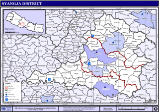
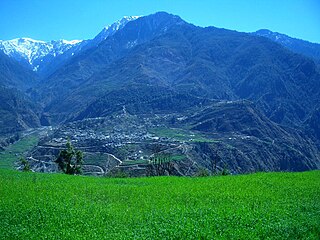
Arukharka is a village development committee in Syangja District in the Gandaki Zone of central Nepal. At the time of the 2011 Nepal census it had a population of 3,397 people living in 878 individual households. The VDC office is located at the sherbazzar which is the VDC center. This is approximately 4 km from Sarketari bazzar of Siddhartha Highway. This VDC consists of one Higher Secondary School Name as Jana Adarsa Higher Secondary School.
Gamhariya is a Village Development Committee in Sarlahi District in the Janakpur Zone of south-eastern Nepal. At the time of the 2011 Nepal census it had a population of 8,000 people residing in 674 individual households. It has two sub villages small Palsi which is hardly 1 km east of the village and other is called Ganesiya which is located at south of the village which is also 1 km. North Ganesiya is associate with Gamhariya identified by ward no 6 and south part is located in Musaili VDC.
Hariwan Municipality is one of the new municipalities declared by the Government of Nepal on May 18, 2014. It is located in Sarlahi District Janakpur zone, Nepal. It is formed by the joining of four contemporary Village development committees (VDCs) namely Atrouli, Sasapur, Ghurkauli and Harion VDCs covering an area of 88.1 km2. It has been divided into 11 wards with an administration center in Harion Bazar. According to Nepal Population Census 2011, the municipality has a total population of 42,783.
Jhalariझलारी is a Village Development Committee in Kanchanpur District in Sudurpashchim Province of South-Far-Western Nepal. At the time of the 1991 Nepal census it had a population of 10,590 people living in 1702 individual households.

Padampur is a municipality in Chitwan District in the Narayani Zone of southern Nepal. At the time of the 1991 Nepal census it had a population of 8,884 people living in 1,559 individual households. It was transferred in new location named Saguntol by Government of Nepal and completed with in 8 years i.e. from 2050 BS to 2058 BS. Previously it was at the lap of Rapati river and inside the Chitwan National Park. Flood of Rapati river in monsoon season destroy farmers crops. Wild animals also harmed their crops. Transportation, electricity, road and educational facilities were beyond people's access. It was known as one of the remote areas of the Chitwan district. In a view of agriculture, It was the best place for farmers. After the new dawn of democracy in 2046, New government was asked to shift this village for peoples safety and conservation of forest and wild animal. The cabinet of Girija Prasad Koirala was assured to shift in a convenience place soon and started the task immediately. This task was successfully done by the politician Baburam Puri of the Nepali Congress. The late Sailaja Acharya visited the people and understood their griefs and proposed to shift it next to Sagoontol near Jutpani VDC. This was a very difficult task to accomplish successfully. People from the Western Chitwan were stood against it but government took bold decision in favour of people of Padampur. Now it is about 2.5 km (1.6 mi) east to Bharatpur, district headquarters of Chitwan. Electricity, roads and transportation facility are comparatively better here. 2,800 households were there now. According to the 2001 census, the total population of the VDC was 11,336 with total households 2,137. Tharus are the dominant ethnic group with 45.89% of the total VDC population. Brahman, Kshetri, Tamang, Gurung and Newar are other castes here. Mainly banana, maize and oil are farmed here. Except ward no 1 there are deep tubewells to Irrigate farmlands. Poultry, dairy, epiculture, mushroom farming and goat keeping have great potentials here. A campus, A higher secondary school, a secondary boarding school and other 7 primary and lower secondary schools are providing education here. Health post, and Post office are too doing their best for providing services to locals. Drinking water is provided in better and modern way. Pipelines of drinking water are available within all roads (113 km) of Padampur. An NGO veterinary office is also serving and helping farmers. Since last 5 years this VDC is starting to be known as one of pocket areas of commercial banana farming of the nation. Nobody is landless here and this is the special feature here. Padampur is very attractive location for migratory view and daily people are migrating here. It is like a colonial place for settlement of people. Government has sifted it in a well planned way and that is why it is the second model VDC of Nepal. Now this village has merged in Kalika Municipality and shares 4 wards in it i.e. Kalika -9, Kalika-10, Kalika-11 and Kalika-12.

Letang, "लेटाङ " is a Municipality in Morang District in the Province No. 1 of south-eastern Nepal. It was formed by merging the existing Village Development Committees of Letang, Jante, Warrangi and Bhogateni.
Edited by ABHASH
Amarapuri is a town in Gaidakot Municipality in Nawalparasi District in the Lumbini Zone of southern Nepal. It became a municipality in May 2014 by merging the existing Mukundapur, Amarapuri, Gaidakot, Nawalparasi, VDCs. At the time of the 1991 Nepal census it had a population of 5,451 living in 967 households. Amarapuri has three high schools, the Shree Laxmi Higher Secondary School, Amar Jyoti Higher Secondary School and Amar English Higher Secondary Boarding School.

Kawasoti (Nepali: कावासोती) is a municipality in Nawalpur District, Gandaki Province, Nepal. It is 31 km (19 mi) west of Bharatpur and 85 km (53 mi) east of Butwal, approximately on the middle of Mahendra Highway. The Naryani River flows south of it, and the Mahabharat Range is north of it.
Bardaghat [नेपाली: बर्दघाट] is a Municipality in Parasi District in Lumbini Province, Nepal. It is situated in the lap of Chure range. This municipality was established on 18 May 2014 by merging existing Makar and Panchanagar VDCs. Again during the local election, the neighbouring VDC Dawanne devi and some part of Dhurkot, Jamuniya, Rupauliya were merged in it. It has a population of 55,382 with the area of 162.05 km2. It is an emerging town of Parasi District that is developing rapidly.
Indrapur(इन्द्रपुर) is a town center under Kosi Haraicha Municipality in Morang District in the Kosi Zone of south-eastern Nepal. Earlier it was a village development committee and was merged into Koshi Haraicha Municipality in May 2014.
Agnisaira Krishnasavaran is a rural municipality in Saptari District in the Sagarmatha Zone of south-eastern Nepal. At the time of the 2017 Nepal census it had a population of 27,129 people living in 2265 individual households.
Pacharauta is a municipality in Bara District in Province No. 2 of South-Eastern Nepal. It was formed in 2016 occupying current 9 sections (wards) from previous 9 former VDCs. It occupies an area of 44.01 km2 with a total population of 34,175.

