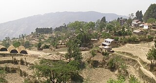
Solududhkunda (earlier:Dudhkunda) is the only municipality of Solukhumbu District. Located in Province No. 1 of Nepal. The town of Salleri, which is located within the municipality is the headquarter of Solukhumbu District It was formed in 2014 by merging four VDCs: Salleri, Garma, Loding Tamakhani and Beni and was divided into 9 wards. Total area of the municipality had 254.3 square kilometres (98.2 sq mi) and population of municipality had 20,399 individuals living in 5,368 households.

A Village Development Committee (VDC) in Nepal was the lower administrative part of its Ministry of Federal Affairs and Local Development. Each district had several VDCs, similar to municipalities but with greater public-government interaction and administration. There were 3,157 village development committees in Nepal. Each VDC was further divided into several wards depending on the population of the district, the average being nine wards.

Mahadevsthan Mandan is a village development committee in Kavrepalanchok District in the Bagmati Zone of central Nepal.

Limi is a village in the eponymously named Limi Valley and a ward council of Namkha rural municipality in Humla District in the Karnali Pradesh of north-western Nepal. Previously the whole valley was known as the Limi Village Development Committee (VDC). As of the 1991 Nepal census, it had a population of 988 persons living in 169 individual households. The population of the village decreased to 904 individual according to 2011 Nepal census

Godamchaur is a village and former Village Development Committee that is now part of Godawari Municipality in Province No. 3 of central Nepal. At the time of the 1991 Nepal census it had a population of 3868 in 645 individual households. It has 9 small wards in this village development committee. Saathali is mostly inhabited by Newars.

Chulachuli is a rural municipality (gaunpalika) out of six rural municipality located in Ilam District of Province No. 1 of Nepal. There are a total of 10 municipalities in Ilam in which 4 are urban and 6 are rural.

Saudiyar is a town and Village Development Committee in Dang Deokhuri District in Lumbini Province of south-western Nepal. At the time of the 1991 Nepal census it had a population of 8,052 persons living in 1067 individual households.

Kakani is a Gaunpalika and former village development committee in Nuwakot District in Bagmati Province of central Nepal. At the time of the 1991 Nepal census, the Kakani village development committee administered a population of 7816 living in 1343 individual households.

Bajung is a village development committee in Parbat District in the Dhawalagiri Zone of Western Development Region, Nepal. It is surrounded by Deupurkot to the north-east, Tilahar to the south-east, Durlung to the south-west and Kyang to the north-west. It is popularly said to be extended from the top of Maidan, a hill-top with historical identity to the basin of Modi River. At the time of the 2011 Nepal census it had a population of 4228 people living in 1,076 individual households.

Dhairing is a village development committee in Parbat District in the Dhawalagiri Zone of central Nepal. At the time of the 2011 Nepal census it had a population of 3456 people living in 896 individual households. Temple Bhume Thann is located here.

Babare is a village in Kalinchowk Rural Municipality in Dolakha District in the Bagmati Province of north-eastern Nepal. At the time of the 1991 Nepal census it had a population of 3392 people living in 739 individual households.

Melung is a Rural municipality located within the Dolakha District of the Bagmati Province of Nepal. The municipality spans 86.54 square kilometres (33.41 sq mi) of area, with a total population of 20,210 according to a 2011 Nepal census.

Doramba is a populated place and a ward of Doramba Rural Municipality. It was a village development committee before 10 March 2017. At the time of the 1991 Nepal census it had a population of 3640 people living in 664 individual households.

Khandadevi is a populated place and a ward of Khandadevi Rural Municipality. It was a village development committee before 10 March 2017. At the time of the 1991 Nepal census it had a population of 3751 people living in 650 individual households.

Parsa is a rural municipality in Sarlahi District, a part of Province No. 2 in Nepal. It is situated 10 km East from Malangwa which is headquarter of Sarlahi. It was formed in 2016 occupying current 6 sections (wards) from previous 6 former VDCs. It occupies an area of 23.12 km2 with a total population of 21,650. The major language spoken in the rural municipality are Maithili and Bajjika.

Katahariya is a municipality in Rautahat District in the Narayani Zone of south-eastern Nepal since September 2017. Before then, Katahariya was one of the Village Development Committees with 8 wards. At the time of the 1991 Nepal census, it had a population of 4,619 people living in 835 individual households. Katahariya is famous for its vegetables and cattle market. It has a well-maintained Farmers' market (vegetable) and Cattle (domestic-animal) market. Katahariya is a fast-growing VDC, with the main occupations of local people being business and farming.

Bayarban was a village development committee in the Morang District, Koshi Zone of south-eastern Nepal. It was named for the village of Bayarban Bazar. In 2017 it was absorbed by the newly created Kanepokhari Rural Municipality.

Pathari Shanishchare (पथरी-शनिश्चरे) is a Municipality in Morang District in the Koshi Zone of south-eastern Nepal. It was formed by merging three existing village development committees i.e. Hasandaha, Pathari and Sanischare in May 2014.

Bhojpur is a neighborhood in Bhojpur Municipality which is located in Bhojpur District in Province No. 1 of Nepal. The Bhojpur Village Panchayat was established in 1962 and was renamed as Bhojpur Village development committee in 1990.


