
Chitwan National Park is the first national park of Nepal. It was established in 1973 as the Royal Chitwan National Park and was granted the status of a World Heritage Site in 1984. It covers an area of 952.63 km2 (367.81 sq mi) in the subtropical Inner Terai lowlands of south-central Nepal in Nawalpur, Chitwan, Makwanpur and Parsa Districts. It ranges in elevation from about 100 m (330 ft) in the river valleys to 815 m (2,674 ft) in the Sivalik Hills.
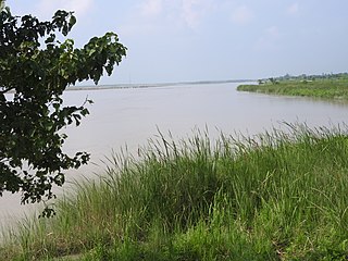
The Koshi Tappu Wildlife Reserve is a protected area in the Terai of eastern Nepal covering 176 km2 (68 sq mi) of wetlands in the Sunsari, Saptari and Udayapur Districts. It comprises extensive reed beds and freshwater marshes in the floodplain of the Kosi River, and ranges in elevation from 75 to 81 m. It was established in 1976 and designated as a Ramsar site in December 1987. It hosts Nepal's last remaining herd of the wild water buffalo.

Chitwan District is one of 77 districts of Nepal, and takes up the southwestern corner of Bagmati Province. Bharatpur, largest city of Nepal after Kathmandu, is its administrative centre. It covers 2,238.39 km2 (864.25 sq mi), and in 2011 had a population of 579,984 people. Bharatpur is the commercial and service centre of South Central Nepal and a major destination for higher education, health care and transportation in the region. Chitwan lies in the Terai region of Nepal. It is in the drainage basin of the Gandaki River and is roughly triangular, taking that river as its meandering northwestern border, and a modest watershed border, with India, as the basis of its southern limit. Local government: Bharatpur Metropolitan, Rapti Municipality, Ratnanagar Municipality, Kalika Municipality, Khairahani Municipality, Madi Municipality, Ikshyakamana Gaupalika

The Terai–Duar savanna and grasslands is a narrow lowland ecoregion at the base of the Himalayas, about 25 km (16 mi) wide, and a continuation of the Indo-Gangetic Plain in India, Nepal and Bhutan. It is colloquially called Terai in the Ganges Basin east to Nepal, then Dooars in West Bengal, Bhutan and Assam east to the Brahmaputra River. It harbours the world's tallest grasslands, which are the most threatened and rare worldwide.
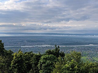
Bharatpur is a city in south central Nepal. It is the third most populous city of Nepal after Kathmandu and Pokhara with 369,377 inhabitants in 2021. It is also the second largest metropolitan city in Nepal by area. It is the district headquarter of the Chitwan District.

Devghat is one of the famous religious and cultural centers in central Nepal. At the time of the 1991 Nepal census it had a population of 5,786 people living in 1,132 individual households.
The Inner Terai Valleys of Nepal comprise several elongated river valleys in the southern lowland Terai part of the country. These tropical valleys are enclosed by the Himalayan foothills, viz the Mahabharat Range and the Sivalik Hills farther south.
Jagatpur is a village development committee in Chitwan District, Bagmati Province, Central Development Region, Nepal. At the time of the 2011 Nepal census it had a population of 11,195 people living in 2,635 individual households.
Kabilas is a former village development committee in Chitwan District Now a part of Bharatpur Metropolitan City in the Bagmati Province of southern Nepal. At the time of the 1991 Nepal census it had a population of 5,513.
Kathar is a village development committee [recently included in Khairahani Municipality] in Chitwan District in the Narayani Zone of southern Nepal. At the time of the 2001 Nepal census it had a population of 8,247 people living in 1,326 individual households. About 60% of people were in agriculture and rest of them are in other. No any company are found. Tourist usually stay with families living in this village rather than at hotels.
Kaule is a village development committee in Chitwan District in the Narayani Zone of southern Nepal. At the time of the 1991 Nepal census it had a population of 3,931 people living in 732 individual households.
Lothar is a village development committee in Chitwan District in the Narayani Zone of southern Nepal. At the time of the 1991 Nepal census it had a population of 3,425 people living in 364 individual households.
Mangalpur is a village in Chitwan District in the Bagmati Province of southern Nepal. It was also a Village Development committee before it merged with Bharatpur. At the time of the 1991 Nepal census it had a population of 12,969 people residing in 2,580 individual households.
Pancha Kanya is a village development committee in Chitwan District in the Narayani Zone of southern Nepal. At the time of the 1991 Nepal census it had a population of 10,281 people living in 1,996 individual households.
Meghauli is a small city and former Village Development Committee that is now part of Bharatpur Metropolitan City in Bagmati Province of central Nepal.
Shivanagar was a village development committee in Chitwan District in the Narayani Zone of southern Nepal. At the time of the 1991 Nepal census it had a population of 6,937 people living in 1,314 individual households.
Siddi is a village development committee in Chitwan District in the Narayani Zone of southern Nepal. At the time of the 1991 Nepal census it had a population of 2,577 people living in 404 individual households.

Parsa National Park is a national park in the Terai of south-central Nepal covering an area of 627.39 km2 (242.24 sq mi) in the Parsa, Makwanpur and Bara Districts and ranging in elevation from 435 to 950 m in the Sivalik Hills. It was established as a wildlife reserve in 1984 and received national park status in 2017. It is surrounded by a buffer zone since 2005 with an area of 285.3 km2 (110.2 sq mi). In 2015, the protected area was further extended by 49 sq mi (128 km2).
The Barandabhar forest covers an area of 87.9 km2 and bisects the Chitwan District in east and west Chitwan. Barandabhar, a 29 km long forest patch, is bisected by the Mahendra Highway, resulting in a 56.9 km2 area in the buffer zone of RCNP and 31 km2 is under the district forest office.
The Bote people are an ethnic group indigenous to the inner Terai regions of Nepal. They speak Bote language. The Bote people are well-known for ferrying travellers across the rivers through the boats, which often are prepared from the trunks of the trees. They are scattered around the bank of Kaligandaki, Narayani and Rapti River of Nepal. Bote and Majhi people are known as the ‘King of water’. Their ancestral occupation is fishing, boating and searching gold in the river whose settlement is nearby river and forest.The dialect and culture of Bote people in several ways is similar to that of the Danuwars, Darai, Tharus and Majhi.

