Tandi is a city in the RatnanagarMunicipality of the Chitwan District in Nepal. It lies on the eastern side of Chitwan district, and is at the entrance point of Sauraha Chitwan National Park, a Major Tourist destination in Nepal.It is the second largest and oldest Urban Area of the district..This Beautiful Town has got the Space for All Major Banks and isurance Co.Of Nepal.This is the fastes Growing Town in Chitwan.It has got a very well Equipped National level Hospital which serves the people around Eastern part of Chitwan and makwanpur District.Almost 95% of the municipal area has got well managed paved roads.Tandi being the heart of the Ratnanagar,it is famous for Entry point to Sauraha and also renowned for Especial Tharu cuisine like ghunghi,Haas ko chhoila etc.this town has got all the basic to advanced facility of a (A-) class Town.
Background
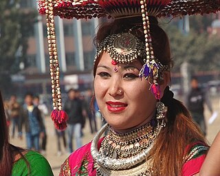
Tandi, the main city in the Ratnanagar municipality of Chitwan district, is home to Chitwan National Park, formerly known as Royal Chitwan National Park, a UNESCO World Heritage Site and a world-renowned tourist destination. Tourism is a major industry of the city and a source of daily living especially for thousands of ethnic minorities called Tharus, who predominantly lived there before waves of migration from nearby hilly regions (mainly Dhading, Tanahu, Lamjung, Baglung, Parbat) came to settle in the place once considered unfriendly for living due to deadly aulo (a disease caused by the bite of a deadly form of mosquito).
Like any other cities in Chitwan, Tandi is inhabited by a very diverse community of people who migrated to this place from different parts of Nepal. It is often said that Chitwan is a 76th district, as this place is traditionally inhabited by people representing all other 75 districts of Nepal. Lying along the East-West Highway at the central part of the country, this place offers an exciting opportunity for people wanting to do business. Poultry and cotton industries, besides the tourism industry, are major industries of the region.
Just about 5km southeast of Tandi after crossing the 'Kayer River' and its tributaries, past Seri village and its open fields and finally the 'Padariya River', there is a historical village called 'Jhuwani'. It was the old headquarters of Chitwan district. Historically, while the Ranas were in power in Nepal, the distribution of population was very thin throughout Nepal and Chitwan. In Chitwan, there were many Tharu communities and in Jhuwani village as well. These indigenous people were considered to be resistant to malaria. Most of Chitwan was covered with dense jungle, mosquitoes and malaria was very prevalent.(Malaria is 'aulo' in Nepal language). Now, Jhuwani village has a secondary school, a resource centre, a newly built community library with thousands of books, newspapers, magazines, computers and internet facilities, many tea shops and general shops (called Kirana shops) and a dairy (milk collection) centre where most of villagers in the morning meet and greet each other. While they are having tea and chatting with their mates about their day-to-day business, the whole atmosphere and feel so good and a pleasure, particularly if you are connected to those people or know them from childhood. In addition, Jhuwani has a youth club called 'Lali Gurash'( Red Rhododendron) and many sport teams from cricket to football are active. There is a large football ground near the bank of the 'Dhumre River'. Next to the football pitch, there is a local community forest where you can spend your extra time with your friends/family.
2km southwest of Jhuwani lies Sauraha- a tourist destination, developed in the 1980s. About 50 different hotels with the usual facilities are available there. In addition, forest walking, village walking, bicycle riding, elephant riding, bird watching, boating on the Rapati river, forex centre, book shops and cafes have sprung up. The most important thing about the place is it is not crowded and the people are really nice and they greet you with a 'special smile'. People around the village are very simple and welcoming, in addition to this, the younger generation are fluent in English. As always as in small communities, most people know each other. There is a direct road which is motorable from Tandi to Jhuwani and Saurha. The life and economy of these places are interconnected.
Tandi, is also the economic center of the Ratnanagar Municipality and the Village District Committees (VDCs) around the municipality.
The Tharu people are an ethnic group indigenous to the Terai in southern Nepal and northern India. They are recognized as an official nationality by the Government of Nepal. In the Indian Terai, they live foremost in Uttarakhand, Uttar Pradesh and Bihar. The Government of India recognizes the Tharu people as a scheduled tribe.
The Terai or Tarai is a lowland region in northern India and southern Nepal that lies south of the outer foothills of the Himalayas, the Sivalik Hills, and north of the Indo-Gangetic Plain. This lowland belt is characterised by tall grasslands, scrub savannah, sal forests and clay rich swamps. In northern India, the Terai spreads from the Yamuna River eastward across Haryana, Uttarakhand, Uttar Pradesh, Bihar and West Bengal. The Terai is part of the Terai-Duar savanna and grasslands ecoregion. The corresponding lowland region in West Bengal, Bangladesh, Bhutan and Assam in the Brahmaputra River basin is called 'Dooars'. In Nepal, the term is applied to the part of the country situated north of the Indo-Gangetic Plain. Nepal's Terai stretches over 33,998.8 km2 (13,127.0 sq mi), about 23.1% of Nepal's land area, and lies at an elevation of between 67 and 300 m. The region comprises more than 50 wetlands. North of the Terai rises the Bhabar, a narrow but continuous belt of forest about 8–12 km (5.0–7.5 mi) wide.
Chitwan National Park is the first national park of Nepal. It was established in 1973 and was granted the status of a World Heritage Site in 1984. It covers an area of 952.63 km2 (367.81 sq mi) and it is located in the subtropical Inner Terai lowlands of south-central Nepal in the districts of Nawalpur, Parasi, Chitwan and Makwanpur. In altitude it ranges from about 100 m (330 ft) in the river valleys to 815 m (2,674 ft) in the Sivalik Hills.
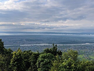
Chitwan District is one of 77 districts of Nepal, and takes up the southwestern corner of Bagmati Province. Bharatpur, largest city of Nepal after Kathmandu, is its administrative centre. It covers 2,238.39 km2 (864.25 sq mi), and in 2011 had a population of 579,984 people. Bharatpur is the commercial and service centre of South Central Nepal and a major destination for higher education, health care and transportation in the region. Chitwan lies in the Terai region of Nepal. It is in the drainage basin of the Gandaki River and is roughly triangular, taking that river as its meandering northwestern border, and a modest watershed border, with India, as the basis of its southern limit. Local government: Bharatpur Metropolitan,Rapti Municipality,Ratnanagar Municipality, Kalika Municipality, Madi Municipality, Ikshyakamana Gaupalika
Bharatpur is a city in southern central Nepal. It is the third most populous city of Nepal after Kathmandu and Pokhara with 369,377 inhabitants in 2021. It is also the second largest metropolitan city in Nepal by area. It is the district headquarter of the Chitwan District.
Ghorahi is the seventh largest city and largest sub-metropolitan city of Nepal. The city lies in Lumbini Province in the Mid-Western part of Nepal. It is the largest city of Dang Deukhuri District of southwest Nepal. Located in the Inner Terai region, it lies 413 kilometres (257 mi) south-west of Nepal's capital Kathmandu and is one of the Counter Magnets being developed as an alternative centre of growth to help ease the migration and population explosion in the Kathmandu metropolitan area. It is the largest city of the Rapti Zone and is surrounded by the Sivalik Hills to the south and Mahabharata Range to the north.
The Inner Terai Valleys of Nepal comprise several elongated river valleys in the southern lowland Terai part of the country. These tropical valleys are enclosed by the Himalayan foothills, viz the Mahabharat Range and the Sivalik Hills farther south.
The Chitwan Valley is an Inner Terai valley in the south of Nepal, encompassing the districts of Makwanpur, Chitwan and Nawalpur. The valley is part of the Terai-Duar savanna and grasslands ecoregion of about 150 km (93 mi) length and 30–48 km (19–30 mi) width.
Gulariya is a municipality and headquarters of Bardiya District in Lumbini Province of south-western Nepal. It is located in the plains of the Terai region near the southern border with the Bahraich district, Uttar Pradesh state of India. It is 35 kilometers west of Nepalgunj and about 10 km north of Murtiha Transit or railway station, India.
Ratnanagar is a municipality in Chitwan District of Bagmati Province in Nepal. It is the second biggest municipality after Bharatpur Metropolitan City that was formed in 1997 through the merger of the former Village Development Committees Old-Ratnanagar and Panchakanya. It is adjacent to Chitwan National Park, and serves as a gateway to the park. Agricultural products produced from Ratnanagar includes rice, maize, mustard and vegetables. This municipality is also a major place for production of poultry products and animal husbandry. Tourism is another source of income generation for the people in Ratnanagar. People are directly or indirectly dependent in tourism industry. Ratnanagar is also concerned in environment preservation so in order to preserve and protect environment, eco-friendly electric risk-shaw has also been introduced and available in different parts of this municipality. It lies on the bank of East Rapti River.
Jagatpur is a village development committee in Chitwan District, Bagmati Province, Central Development Region, Nepal. At the time of the 2011 Nepal census it had a population of 11,195 people living in 2,635 individual households.
Kumroj is a town in Khairhani Municipality in Chitwan District in the Narayani Zone of southern Nepal. The municipality was promulgated on 18 May 2014 by merging the existing Khairahani, Kumroj and Chainpur VDCs. Kumroj is 190 km south-west of the Kathmandu valley stationed in the Rapti valley, also known as the Inner Terai or Dun. The village is situated at an altitude of 1000 ft above the sea level surrounded by two mountain ranges; the mahabharat ranges of hills on the north and the churiya siwalik hills on the south. The main point of attraction is the Chitwan National Park which today stands as a successful testimony of nature conservation in south Asia Region. Historically it was established in 1973 as the first national park of the Nepal to preserve a unique ecosystems significantly valuable to the whole world en routing this area on the world heritage site list in 1984. In the near future, this town would be one of the potential Eco-tourism village destination. Kumroj is dedicated to protect the wild animals, community forest and the Chitwan national park. Once the Southern belt of Nepal was afflicted by malaria epidemics. Tharu, the native tribe, were able to thrive even in malaria. As malaria subsided, more and more people started migrating in this place in the search of arable land, which eventually made Kumroj as a multicultural and multiethinic place. Irrigated low land has been the main stud of agriculture, permitting Rice-Rice-Pulse cropping pattern feasible.
Meghauli is a village and former Village Development Committee that is now part of Bharatpur Metropolitan City in Bagmati Province of central Nepal.
Padampur is a municipality in Chitwan District in the Narayani Zone of southern Nepal. At the time of the 1991 Nepal census it had a population of 8,884 people living in 1,559 individual households. It was transferred in new location named Saguntol by Government of Nepal and completed with in 8 years i.e. from 2050 BS to 2058 BS. Previously it was at the lap of Rapati river and inside the Chitwan National Park. Flood of Rapati river in monsoon season destroy farmers crops. Wild animals also harmed their crops. Transportation, electricity, road and educational facilities were beyond people's access. It was known as one of the remote areas of the Chitwan district. In a view of agriculture, It was the best place for farmers. After the new dawn of democracy in 2046, New government was asked to shift this village for peoples safety and conservation of forest and wild animal. The cabinet of Girija Prasad Koirala was assured to shift in a convenience place soon and started the task immediately. This task was successfully done by the politician Baburam Puri of the Nepali Congress. The late Sailaja Acharya visited the people and understood their griefs and proposed to shift it next to Sagoontol near Jutpani VDC. This was a very difficult task to accomplish successfully. People from the Western Chitwan were stood against it but government took bold decision in favour of people of Padampur. Now it is about 2.5 km (1.6 mi) east to Bharatpur, district headquarters of Chitwan. Electricity, roads and transportation facility are comparatively better here. 2,800 households were there now. According to the 2001 census, the total population of the VDC was 11,336 with total households 2,137. Tharus are the dominant ethnic group with 45.89% of the total VDC population. Brahman, Kshetri, Tamang, Gurung and Newar are other castes here. Mainly banana, maize and oil are farmed here. Except ward no 1 there are deep tubewells to Irrigate farmlands. Poultry, dairy, epiculture, mushroom farming and goat keeping have great potentials here. A campus, A higher secondary school, a secondary boarding school and other 7 primary and lower secondary schools are providing education here. Health post, and Post office are too doing their best for providing services to locals. Drinking water is provided in better and modern way. Pipelines of drinking water are available within all roads (113 km) of Padampur. An NGO veterinary office is also serving and helping farmers. Since last 5 years this VDC is starting to be known as one of pocket areas of commercial banana farming of the nation. Nobody is landless here and this is the special feature here. Padampur is very attractive location for migratory view and daily people are migrating here. It is like a colonial place for settlement of people. Government has sifted it in a well planned way and that is why it is the second model VDC of Nepal. Now this village has merged in Kalika Municipality and shares 4 wards in it i.e. Kalika -9, Kalika-10, Kalika-11 and Kalika-12.
Pithuwa is one of the developed suburb area of Ratnanagar Municipality in Chitwan District in the Narayani Zone of southern Nepal. The area consists of Ward No. 13, 14 & 15. According to 2011 Nepal census survey it had a population of 12,579 people living in 2,898 individual households. Pithuwa is located West to the Kayer river [कयर खोला], East and North to Tandi and South to Khairhani Municipality. Most people of this suburbs are immigrants of Gorkha and Dhading districts. It lies in constituency region no. 2 out of five constituencies of Chitwan. The total population living here are the more immigrated from the hills, especially from Gorkha and Dhading districts. Here are also some indigenous communities, various ethnic group which co-relate their individual values and cultures like Tharus and Darais. Jana Jagriti Higher Secondary School [जन जागृती उच्च. मा. बि.], only higher secondary school of the suburbs which is the sole provider of higher education and periphery since about 5 decades. It is one of the most beautiful place of the Eastern Chitwan. It is close to the famous tourist place such as Saurah & Chitwan National Park (CNP).
Sauraha is a village of Ratnanagar Municipality in Chitwan District and Chitwan Valley, in Bagmati Province of southern Nepal.
Devchuli is a municipality in Nawalpur District in the Lumbini Zone of southern Nepal. At the time of the 2011 Nepal census it had a population of 42,603 people living in 916 individual households. The municipality was established on 18 May 2014 by merging the preexisting Devchuli, Dibyapuri, Pragatinagar VDCs and later Rajahar VDC. The Narayani River flows in the vicinity. Northern side of the municipality is covered by hills with major population of ethnic Magar people and their culture. Northern areas are also least developed, rural and lack basic infrastructures, such as roads, hospitals and clean drinking water supply. Southern plain areas are developing and has major concentration of population. Municipality has great ethnic and cultural diversity, made of indigenous Tharu, Magar and all other major ethnic groups and culture residing harmoniously.
Kawasoti (Nepali: कावासोती) is a municipality in Nawalpur District, Gandaki Province, Nepal. It is 31 km (19 mi) west of Bharatpur and 85 km (53 mi) east of Butwal, approximately on the middle of Mahendra Highway. The Naryani River flows south of it, and the Mahabharat Range is north of it.
Maula Kalika is a famous Hindu temple of Goddess Kalika in Gaindakot town of Nawalpur district in Gandaki province of Nepal.
Gaindakot is a municipality in Nawalpur District in the Lumbini Zone of southern Nepal. It became a municipality in May 2014 by merging the existing Mukundapur, Amarapuri, and Gaindakot VDCs. It was again expanded by merging Ratanpur VDC. It is situated on the shore of Narayani River in the lap of Maula Kalika temple. So this place has a great possibility of tourism development. At the time of the 2011 Nepal census, it had a population of 58,841 and 13,623 individual households according to 2011 Nepal census. Contributed in the article by Prashant Subedi
This page is based on this Wikipedia article Text is available under the CC BY-SA 4.0 license; additional terms may apply. Images, videos and audio are available under their respective licenses.