Kathmandu, officially the Kathmandu Metropolitan City, is the seat of federal government and the most populous city in Nepal. As of the 2021 Nepal census, there were 845,767 inhabitants living in 105,649 households and approximately 4 million people in its surrounding agglomeration. It is located in the Kathmandu Valley, a large valley surrounded by hills in the high plateaus in central Nepal, at an altitude of 1,400 metres.
Nepal is a multi-ethnic, multiracial, multicultural, multi-religious, and multilingual country. The most spoken language is Nepali followed by several other ethnic languages.
Mount Everest(also Mount Sagarmatha or Mount Qomolangma) is Earth's highest mountain above sea level, located in the Mahalangur Himal sub-range of the Himalayas. The China–Nepal border runs across its summit point. Its elevation of 8,848.86 m was most recently established in 2020 by the Chinese and Nepali authorities.
The Kingdom of Nepal was a Hindu kingdom in South Asia, formed in 1768 by the expansion of the Gorkha Kingdom, which lasted until 2008 when the kingdom became the Federal Democratic Republic of Nepal. It was also known as the Gorkha Empire, or sometimes Asal Hindustan. Founded by King Prithvi Narayan Shah, a Gorkha monarch who claimed to be of Thakuri origin from chaubisi, it existed for 240 years until the abolition of the Nepalese monarchy in 2008. During this period, Nepal was formally under the rule of the Shah dynasty, which exercised varying degrees of power during the kingdom's existence.
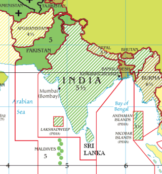
Nepal, officially the Federal Democratic Republic of Nepal, is a landlocked country in South Asia. It is mainly situated in the Himalayas, but also includes parts of the Indo-Gangetic Plain. It borders the Tibet Autonomous Region of China to the north, and India to the south, east, and west, while it is narrowly separated from Bangladesh by the Siliguri Corridor, and from Bhutan by the Indian state of Sikkim. Nepal has a diverse geography, including fertile plains, subalpine forested hills, and eight of the world's ten tallest mountains, including Mount Everest, the highest point on Earth. Kathmandu is the nation's capital and the largest city. Nepal is a multi-ethnic, multi-lingual, multi-religious and multi-cultural state, with Nepali as the official language.
The Communist Party of Nepal (Maoist Centre) (Nepali: नेपाल कम्युनिस्ट पार्टी (माओवादी केन्द्र)), abbreviated CPN (Maoist Centre) or CPN (MC), is the third largest political party in Nepal and a member party of Samajbadi Morcha. It was founded in 1994 after breaking away from the Communist Party of Nepal (Unity Centre). The party launched an armed struggle in 1996 against the Nepalese government. In 2006, the party formally joined mainstream politics after signing a peace agreement following the 2006 Nepalese revolution.
Newar is a Sino-Tibetan language spoken by the Newar people, the indigenous inhabitants of Nepal Mandala, which consists of the Kathmandu Valley and surrounding regions in Nepal. The language is known officialy in Nepal as Nepal Bhasa, a name that has been historically used for the language. The term "Newari" is also used to refer to the language, although the Indic -i suffix is considered inappropriate by some Newar speakers.
The Nepal national football team represents Nepal in International men's football, and is governed by the All Nepal Football Association (ANFA). A member of the Asian Football Confederation (AFC), the Nepali football team plays their home games at Dasharath Stadium in Kathmandu.
Buddhism in Nepal started spreading since the reign of Ashoka through Indian and Tibetan missionaries. The Kiratas were the first people in Nepal who embraced the Buddha’s teachings, followed by the Licchavis and Newar people. Buddhism is Nepal's second-largest religion, with 8.2% of the country's population, or approximately 2.4 million people, identifying as adherents of Buddhism in a 2021 census.
The Nepal men's national cricket team represents Nepal in men's International cricket and is governed by the Cricket Association of Nepal (CAN). They have been a Associate Member of the International Cricket Council (ICC) since 1996. Nepal were awarded Twenty20 International (T20I) status by the ICC in June 2014 until the 2015 ICC World Twenty20 Qualifier and earned One Day International (ODI) status in 2018.
Nepal Standard Time (NPT) is the time zone for Nepal. With a time offset from Coordinated Universal Time (UTC) of UTC+05:45 all over Nepal, it is one of only three time zones with a 45-minute offset from UTC.
Nepali are the citizens of Nepal under Nepali nationality law. The term Nepali usually refers to the nationality, that is, to people with citizenship of Nepal, while the people without Nepalese citizenship but with roots in Nepal are strictly referred to as Nepali-language Speaking Foreigners who are speakers of Nepali, Maithili or any of the other 128 Nepali languages but are now foreign citizens or of foreign nationality bearing passports and citizenship of the foreign nation. It is also not generally used to refer to non-citizen residents, dual citizens, and expatriates.
The 1991 Nepal census was a widespread national census conducted by the Nepal Central Bureau of Statistics.
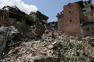
The April 2015 Nepal earthquake killed 8,962 people and injured 21,952 across the Nepal, India, China and Bangladesh. It occurred at on Saturday 25 April 2015, with a magnitude of 7.8Mw or 8.1Ms and a maximum Mercalli Intensity of X (Extreme). Its epicenter was east of Gorkha District at Barpak, Gorkha, roughly 85 km (53 mi) northwest of central Kathmandu, and its hypocenter was at a depth of approximately 8.2 km (5.1 mi). It was the worst natural disaster to strike Nepal since the 1934 Nepal–India earthquake. The ground motion recorded in Kathmandu, the capital of Nepal, was of low frequency, which, along with its occurrence at an hour when many people in rural areas were working outdoors, decreased the loss of human lives.
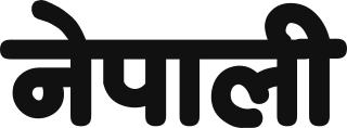
Nepali is an Indo-Aryan language native to the Himalayas region of South Asia. It is the official, and most widely spoken, language of Nepal, where it also serves as a lingua franca. Nepali has official status in the Indian state of Sikkim and in the Gorkhaland Territorial Administration of West Bengal. It is spoken by about a quarter of Bhutan's population. Nepali also has a significant number of speakers in the states of Arunachal Pradesh, Assam, Himachal Pradesh, Manipur, Meghalaya, Mizoram and Uttarakhand. In Myanmar it is spoken by the Burmese Gurkhas. The Nepali diaspora in the Middle East, Brunei, Australia and worldwide also use the language. Nepali is spoken by approximately 19 million native speakers and another 14 million as a second language.
Provinces of Nepal officially the Autonomous Nepalese Provinces were formed on 20 September 2015 in accordance with Schedule 4 of the Constitution of Nepal. The seven provinces were formed by grouping the existing districts. The current system of seven provinces replaced an earlier system where Nepal was divided into 14 administrative zones which were grouped into five development regions.
A gaunpalika is an administrative division in Nepal. The Ministry of Federal Affairs and Local Development dissolved the existing village development committees and announced the establishment of this new local body. It is a sub-unit of a district. There are currently 481 rural municipalities.
The COVID-19 pandemic in Nepal was part of the worldwide pandemic of coronavirus disease 2019 caused by severe acute respiratory syndrome coronavirus 2. The first case in Nepal was confirmed on 23 January 2020 when a 31-year-old student, who had returned to Kathmandu from Wuhan on 9 January, tested positive. It was also the first recorded case of COVID-19 in South Asia. Nepal's first case of local transmission was confirmed on 4 April in Kailali District. The first death occurred on 14 May. A country-wide lockdown came into effect on 24 March 2020, and ended on 21 July 2020. As of 26 July 2022, the Ministry of Health and Population (MoHP) has confirmed a total of 984,475 cases, 968,802 recoveries, and 11,959 deaths in the country. In the meantime, 5,804,358 real-time RT-PCR (RT-qPCR) tests have been performed in 40 laboratories across the country. The viral disease has been detected in all provinces and districts of the country, with Bagmati Province and Kathmandu being the worst hit province and district respectively. As for Nepalese abroad, as of 26 July 2020, the Non-Resident Nepali Association has reported a total of 12,667 confirmed cases, 16,190 recoveries, and 161 deaths across 35 countries.
This page is based on this Wikipedia article Text is available under the CC BY-SA 4.0 license; additional terms may apply. Images, videos and audio are available under their respective licenses.