Irañeta is a town and municipality located in the province and autonomous community of Navarre, northern Spain. It is located 195 miles North-East of Spain's capital city, Madrid. Its current population as of 2017 is a 174.

Krasnyi Luch or Khrustalny is a city in the Luhansk Oblast (province) of south-eastern Ukraine, currently controlled by the Lugansk People's Republic. It is incorporated as a city of oblast significance. Its population is approximately 81,389 (2017 est.).
Gulistan-e-Johar or Gulistan-e-Jauhar is one of the major neighbourhoods of Gulshan Town in Karachi, Sindh, Pakistan. Some blocks of the neighborhood fall into Faisal Cantonment Board's administration. This neighborhood is named after Maulana Mohammad Ali Jauhar. Maulana Mohammad Ali Jauhar was one of the founders and former president of the All-India Muslim League and one of the major leaders of Pakistan Movement. Construction started in Gulistan-e-Jauhar in 1986 from Block 19.
Babine Mountains Provincial Park is a provincial park in British Columbia, Canada, located to the east of the Bulkley River between the town of Smithers (SW) and Babine Lake (NE). Established by Order-in-Council as the Babine Mountains Recreation Area in 1984, it was upgraded to park status and its name changed in 1999. It contains approximately 31,465 hectares.

Magüí Payán is a town and municipality in the Nariño Department, Colombia.

Villablino is a municipality located in the Laciana comarca, province of León, Castile and León, Spain. According to the 2011 Census, the municipality had a population of 10,353 inhabitants. It has the largest commercial, economic and social center of Northwest province, and it is one of the judicial districts in the province of León.

Mahamud is a municipality and town located in the province of Burgos, Castile and León, Spain. According to the 2004 census (INE), the municipality has a population of 159 inhabitants.
Olmedillo de Roa is a municipality and town located in the province of Burgos, Castile and León, Spain. According to the 2004 census (INE), the municipality has a population of 194 inhabitants.

Olmillos de Muñó is a municipality and town located in the province of Burgos, Castile and León, Spain. According to the 2004 census (INE), the municipality has a population of 41 inhabitants.
Covaleda is a municipality located in the province of Soria, Castile and León, Spain. According to the 2004 census (INE), the municipality had a population of 1,924 inhabitants.

Palazuelo de Vedija is a municipality located in the province of Valladolid, Castile and León, Spain. According to the 2004 census (INE), the municipality has a population of 241 inhabitants.
Kantueu Pir is a khum (commune) of Banan District in Battambang Province in north-western Cambodia.
Lusadzor is a town in the Tavush Province of Armenia.
Pashupatinagar is a village development committee in Bardiya District in the Bheri Zone of south-western Nepal. At the time of the 1991 Nepal census it had a population of 4,766 and had 613 houses in the town.
Dougouolo is a small town and commune in the Cercle of Bla in the Ségou Region of southern-central Mali. As of 1998 the commune had a population of 7,120.
La Perla is a Municipality in Veracruz, Mexico. It is located in central zone of the State of Veracruz, about 75 km from state capital Xalapa. It has a surface of 199.880 km2. It is located at 18°56′N97°08′W.
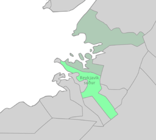
Reykjavík Constituency South is one of the six constituencies of Iceland. Its major city, and the only one included, is Reykjavík.
Manso Adubia is a town in the Ashanti Region of Ghana. The town is known for the Manso Adubia Senior High School.

Gôh-Djiboua District is one of fourteen administrative districts of Ivory Coast. The district is located in the southwest corner of the country. The capital of the district is Gagnoa.

Gôh Region is one of the 31 regions of Ivory Coast. Since its establishment in 2011, it has been one of two regions in Gôh-Djiboua District. The region's seat is Gagnoa and its area is 7327 km². At the 2014 census, the region had a population of 876,117.