The Arctic Archipelago, also known as the Canadian Arctic Archipelago, is a group of islands north of the Canadian mainland.

Daimiel is a municipality in Ciudad Real, Castile-La Mancha, Spain. It has a population of 17,342. The Tablas de Daimiel National Park, a well-known natural reserve, lies partly within the boundaries of the town.
Puebla de Don Rodrigo is a municipality in Ciudad Real, Castile-La Mancha, Spain. It has a population of 1,327.
Ainja is a village in Mulgi Parish in Viljandi County in southern Estonia. It borders the villages Mäeküla, Sudiste, Karksi, Kõvaküla and Äriküla as well as Helme Parish.

Túquerres is a town and municipality in the Nariño Department, Colombia.
Villaumbrales is a municipality located in the province of Palencia, Castile and León, Spain. According to the 2004 census (INE), the municipality has a population of 814 inhabitants.
Gmina Siennica is a rural gmina in Mińsk County, Masovian Voivodeship, in east-central Poland. Its seat is the village of Siennica, which lies approximately 10 kilometres (6 mi) south-east of Mińsk Mazowiecki and 44 km (27 mi) south-east of Warsaw.

Solenzo is a department or commune of Banwa Province in western Burkina Faso. Its capital lies at the town of Solenzo. According to the 1996 census the department has a total population of 115,927.
Kougri is a village in the Zam Department of Ganzourgou Province in central Burkina Faso. The village has a population of 4110.
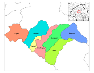
Manegsombo is a village in the Kombissiri Department of Bazèga Province in central Burkina Faso. The village has a population of 373.

Wielkie Budziska is a village in the administrative district of Gmina Cekcyn, within Tuchola County, Kuyavian-Pomeranian Voivodeship, in north-central Poland. It lies approximately 7 kilometres (4 mi) north-east of Cekcyn, 16 km (10 mi) east of Tuchola, and 56 km (35 mi) north of Bydgoszcz.

Wola Bałucka is a village in the administrative district of Gmina Łask, within Łask County, Łódź Voivodeship, in central Poland. It lies approximately 6 kilometres (4 mi) north-west of Łask and 33 km (21 mi) south-west of the regional capital Łódź.
Wólka Pełkińska is a village in the administrative district of Gmina Jarosław, within Jarosław County, Subcarpathian Voivodeship, in southeastern Poland. It lies approximately 9 kilometres (6 mi) northwest of Jarosław and 45 km (28 mi) east of the regional capital Rzeszów.

Siennica is a village in Mińsk County, Masovian Voivodeship, in east-central Poland. It is the seat of the gmina called Gmina Siennica. It lies approximately 12 kilometres (7 mi) south of Mińsk Mazowiecki and 45 km (28 mi) east of Warsaw.
Bylino is a village in the administrative district of Gmina Staroźreby, within Płock County, Masovian Voivodeship, in east-central Poland. It lies approximately 8 kilometres (5 mi) east of Staroźreby, 27 km (17 mi) east of Płock, and 77 km (48 mi) north-west of Warsaw.
Konopki is a village in the administrative district of Gmina Biała Piska, within Pisz County, Warmian-Masurian Voivodeship, in northern Poland. It lies approximately 2 kilometres (1 mi) east of Biała Piska, 19 km (12 mi) east of Pisz, and 106 km (66 mi) east of the regional capital Olsztyn.
Radievo is a village in the municipality of Dimitrovgrad, in Haskovo Province, in southern Bulgaria.
Kooli is a village in Kanepi Parish, Põlva County in southeastern Estonia.
Tõruvere is a village in Peipsiääre Parish, Tartu County in eastern Estonia.
At Dwala is a town and commune in Tizi Ouzou Province in northern Algeria. At Dwala, or Aït Douala, is located 17 km south-east of Tizi-Ouzou.