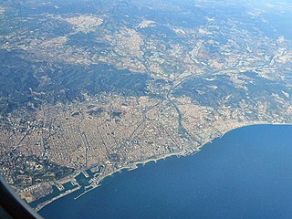
Barcelona is a province of eastern Spain, in the center of the autonomous community of Catalonia. The province is bordered by the provinces of Tarragona, Lleida, and Girona, and by the Mediterranean Sea. Its area is 7,726 km2 (2,983 sq mi). 5,609,350 people live in the province, of whom about 30% (1,620,343) live within the administrative limits of the city of Barcelona, which itself is contained in the Barcelona metropolitan area.
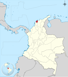
Atlántico is a department of Colombia, located in northern Colombia with the Caribbean Sea to its north, the Bolívar Department to its west and south separated by the Canal del Dique, and the Magdalena Department to its east separated by the Magdalena River. It is the third-smallest of the country's departments but its population of 2,272,170 makes it one of the most densely populated.

Hidalgo is a town of approximately 20,000 people, and seat of the Municipality of Hidalgo. It is located in the state of Nuevo León, in Northeastern Mexico.

Kashgar Prefecture, officially known as Kashi Prefecture, is located in southwestern Xinjiang, China. It has an area of 112,057 km2 (43,265 sq mi) and 4,499,158 inhabitants at the 2015 census with a population density of 35.5 inhabitants/km² ). The capital of the prefecture is the city of Kashgar which has a population 506,640.
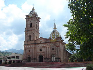
Timaná is a town and municipality in the Huila Department, Colombia. The municipality is located in the south of Huila at an altitude of 1,100 metres (3,600 ft) and 166 kilometres (103 mi) southwest of the capital Neiva.
Villaralto is a city located in the province of Córdoba, Spain. According to the 2006 census (INE), the city has a population of 1350 inhabitants.
Jaulín is a municipality located in the province of Zaragoza, Aragon, Spain. According to the 2004 census (INE), the municipality has a population of 307 inhabitants.
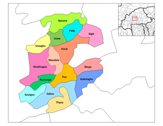
Poa is a department or commune of Boulkiemdé Province in central Burkina Faso. As of 2005 it has a population of 30,406. Its capital lies at the town of Poa.
Douré, Doulougou is a village in the Doulougou Department of Bazèga Province in central Burkina Faso. The village has a population of 658.
Rakaye Mossi is a village in the Doulougou Department of Bazèga Province in central Burkina Faso. The village has a population of 425.
Rakaye Yarcé is a town in the Doulougou Department of Bazèga Province in central Burkina Faso. The town has a population of 1,159.
Toghin is a town in the Doulougou Department of Bazèga Province in central Burkina Faso. The town has a population of 1,105.

Gieczno is a village in the administrative district of Gmina Zgierz, within Zgierz County, Łódź Voivodeship, in central Poland. It lies approximately 15 kilometres (9 mi) north of Zgierz and 23 km (14 mi) north of the regional capital Łódź.
Rudze is a village in the administrative district of Gmina Zator, within Oświęcim County, Lesser Poland Voivodeship, in southern Poland. It lies approximately 2 kilometres (1 mi) south-east of Zator, 18 km (11 mi) south-east of Oświęcim, and 36 km (22 mi) west of the regional capital Kraków.
Morownica is a village in the administrative district of Gmina Śmigiel, within Kościan County, Greater Poland Voivodeship, in west-central Poland. It lies approximately 5 kilometres (3 mi) south-west of Śmigiel, 17 km (11 mi) south-west of Kościan, and 56 km (35 mi) south-west of the regional capital Poznań.
Cisew Mały is a village in the administrative district of Gmina Turek, within Turek County, Greater Poland Voivodeship, in west-central Poland. It lies approximately 6 kilometres (4 mi) south-west of Turek and 115 km (71 mi) south-east of the regional capital Poznań.
Radawnica is a village in the administrative district of Gmina Złotów, within Złotów County, Greater Poland Voivodeship, in west-central Poland. It lies approximately 11 kilometres (7 mi) north of Złotów and 117 km (73 mi) north of the regional capital Poznań.

HMS Lady Shirley (T464), also known as HMT Lady Shirley, was a fishing trawler requisitioned by the Royal Navy in 1940 and converted for anti-submarine warfare duties. She sank U-111 on 4 October 1941, capturing 44 of her crew. Lady Shirley was sunk herself on 11 December 1941, by a single torpedo from U-374

Andorra-Sierra de Arcos is a comarca in Aragon, Spain. It is located in Teruel Province and it is named after Sierra de Arcos, a range of this mountainous area of the Sistema Ibérico. The capital is Andorra, with 8,156 inhabitants the largest town of the comarca.


