The geography of France consists of a terrain that is mostly flat plains or gently rolling hills in the north and west and mountainous in the south and the east.

Šajkaš is a village located in the Titel municipality, in the South Bačka District of Serbia. It is situated in the Autonomous Province of Vojvodina. The village has a Serb ethnic majority and its population numbering 4,550 people.

Záhradné is a village and municipality in Prešov District in the Prešov Region of eastern Slovakia.
German submarine U-772 was a Type VIIC U-boat of Nazi Germany's Kriegsmarine during World War II.

Alexandru Odobescu is a commune in Călărași County, Romania. It is composed of three villages: Alexandru Odobescu, Nicolae Bălcescu and Gălățui.
Girote, is a village and Union council in Khushab District, Punjab, Pakistan and is region 28 out of 51. It is situated on the western Bank of River Jehlum, and 26 kilometres (16 mi) towards south from Khushab. Specifically, it is located at 32°5'6N 72°16'29E. The village has a Branch of MCB Bank, a basic health facility, and a Post Office.
Gornet-Cricov is a commune in Prahova County, Romania. It has a population of 2,621 (2007) and is composed of six villages: Coșerele, Dobrota, Gornet-Cricov, Priseaca, Țărculești and Valea Seacă.
Cața is a commune in Brașov County, Romania. It is composed of five villages: Beia, Cața, Drăușeni, Ionești and Paloș. There are three fortified churches in the commune, at Cața, Beia and Drăușeni.

Copăceni is a commune in Ilfov County, Romania, established in 2005 when it was split off from 1 Decembrie. It is composed of a single village, Copăceni.
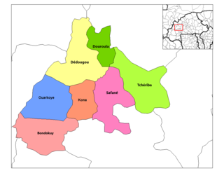
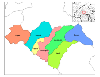
Tchériba is a department or commune of Mouhoun Province in western Burkina Faso. Its capital lies at the town of Tchériba. According to the 1996 census the department has a total population of 36,818.
Kougri is a village in the Zam Department of Ganzourgou Province in central Burkina Faso. The village has a population of 4110.
Watinga is a village in the Saponé Department of Bazèga Province in central Burkina Faso. The village has a population of 353.

Koty is a village in the administrative district of Gmina Łomża, within Łomża County, Podlaskie Voivodeship, in north-eastern Poland. It lies approximately 16 kilometres (10 mi) south-east of Łomża and 61 km (38 mi) west of the regional capital Białystok.
Lutostań is a village in the administrative district of Gmina Łomża, within Łomża County, Podlaskie Voivodeship, in north-eastern Poland. It lies approximately 16 kilometres (10 mi) south-east of Łomża and 61 km (38 mi) west of the regional capital Białystok.

Monesterio is a Spanish municipality in the province of Badajoz, Extremadura. It has a population of 4,368 (2007) and an area of 322.4 km².

Lương Thượng is a commune (xã) and village in Na Rì District, Bắc Kạn Province, in Vietnam.

Jestřabí Lhota is a village and municipality in Kolín District in the Central Bohemian Region of the Czech Republic.

Smoky Falls is a community in Cochrane, Unorganized, North Part in Cochrane District, Ontario, Canada.
Cuautlancingo Municipality is a town and municipality in Puebla, south-eastern Mexico. It is part of the Metropolitan area of Puebla. The town is bordered on the north by the state of Tlaxcala, Tlaxcala, east to the municipality of Tlaxcala and the city of Puebla, to the south with the municipality of San Pedro Cholula and Puebla and west by the municipality of Coronango.
HMS Nyasaland (K587) was a Colony-class frigate of the United Kingdom that served during World War II. She originally was ordered by the United States Navy as the Tacoma-class patrol frigateUSS Hoste (PF-83) and was transferred to the Royal Navy prior to completion.