
The Arctic Archipelago, also known as the Canadian Arctic Archipelago, is a group of islands north of the Canadian mainland.
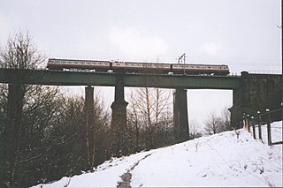
Dinting is a district of Glossop in Derbyshire, England. The district falls within the Simmondley ward of the High Peak Council. It is a small village and has no shops; apart from a chip shop. The nearest are in neighbouring Glossop or Hadfield. However, there is a small primary school, Dinting C of E, located near the viaduct. The 1st Dinting Scout Group has been very active since 1938. The village is served by Dinting railway station. It is notable for the structure Dinting Arches, part of the Glossop Line which goes as far as Manchester Piccadilly railway station, and the Dinting Railway Centre, which was run by the Bahamas Locomotive Society until it closed in 1991 due to lease difficulties. The museum moved to the Ingrow station alongside the Keighley and Worth Valley Railway Line.

Eck en Wiel is a village in the Dutch province of Gelderland. It is a part of the municipality of Buren, and lies about 9 km southwest of Veenendaal.
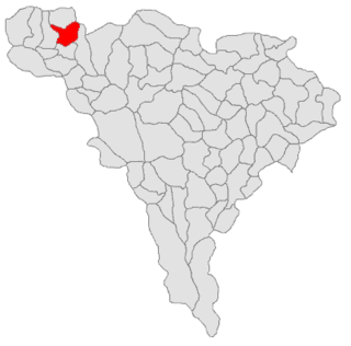
Albac is a commune located in Alba County, Romania. It has a population of 2,220, and is composed of sixteen villages: Albac, Bărăști, Budăiești, Cionești, Costești, Dealu Lămășoi, Deve, După Pleșe, Fața, Pleșești, Potionci, Rogoz, Roșești, Rusești, Sohodol and Tamborești.

Higueruela is a municipality located at 43 km east of Albacete, Castile-La Mancha, Spain. It has a population of 1,350. The land surface is around 205.4 km² and its population density is calculated at 6.5/km².

Magyarbánhegyes is a village in Békés County, in the Southern Great Plain region of south-east Hungary.
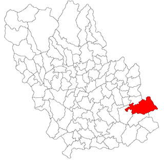
Baba Ana is a commune in Prahova County, Romania. It is composed of five villages: Baba Ana, Cireșanu, Conduratu, Crângurile and Satu Nou.

Pedro Abad is a small town located in the province of Córdoba, Spain. According to the 2006 census (INE), the city has a population of 2934 inhabitants.

Carriches is a municipality located in the province of Toledo, Castile-La Mancha, Spain. According to the 2006 census (INE), the municipality has a population of 296 inhabitants.

Powidzko is a village in the administrative district of Gmina Żmigród, within Trzebnica County, Lower Silesian Voivodeship, in south-western Poland. Prior to 1945 it was in Germany.

Siby is a department or commune of Balé Province in southern Burkina Faso. Its capital lies at the town of Siby. According to the 1996 census the department has a total population of 12,089.

Horea is a commune located in Alba County, Romania. It has a population of 2,371, and is composed of fifteen villages: Baba, Butești, Dârlești, Fericet, Giurgiuț, Horea, Măncești, Mătișești, Niculești, Pătrușești, Petreasa, Preluca, Teiu, Trifești and Zânzești.
Kossoba is a town in the Sanaba Department of Banwa Province in western Burkina Faso. As of 2005 it had a population of 1,975.

Palmierowo is a village in the administrative district of Gmina Kcynia, within Nakło County, Kuyavian-Pomeranian Voivodeship, in north-central Poland. It lies approximately 4 kilometres (2 mi) south-west of Kcynia, 22 km (14 mi) south-west of Nakło nad Notecią, and 41 km (25 mi) south-west of Bydgoszcz.
Wszebory is a village in the administrative district of Gmina Kolno, within Kolno County, Podlaskie Voivodeship, in north-eastern Poland. It lies 5 kilometres (3 mi) north-east of Kolno and 89 km (55 mi) north-west of the regional capital Białystok.
Rogóźno is a village in the administrative district of Gmina Zgierz, within Zgierz County, Łódź Voivodeship, in central Poland. It lies approximately 14 kilometres (9 mi) north of Zgierz and 21 km (13 mi) north of the regional capital Łódź.
Chyangli is a village development committee in Gorkha District in the Gandaki Zone of northern-central Nepal. At the time of the 1991 Nepal census it had a population of 5,612 and had 1066 houses in the town.
Budy Bolewskie is a village in the administrative district of Gmina Stupsk, within Mława County, Masovian Voivodeship, in east-central Poland. It lies approximately 8 kilometres (5 mi) south of Stupsk, 18 km (11 mi) south of Mława, and 92 km (57 mi) north-west of Warsaw.
Garvanovo is a village in the municipality of Haskovo, in Haskovo Province, in southern Bulgaria.
Lensko is a village in the municipality of Ivaylovgrad, in Haskovo Province, in southern Bulgaria.


