Carregado is a former civil parish, located in the municipality of Alenquer, in western Portugal. In 2013, the parish merged into the new parish Carregado e Cadafais. It has a population of 9,066 inhabitants and a total area of 15.52 km². The town is a north-east exurb of Lisbon.

San Francisco de Yojoa is a municipality in the Honduran department of Cortés. Its religious composition is majority Christian, with a lesser presence of Christian Evangelics.

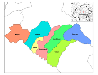
Grenadines is an administrative parish of Saint Vincent and the Grenadines. Its capital is Port Elizabeth.
Higueras is a municipality in Nuevo León, Mexico. It has an area of 600.2 square kilometers. It is bordered on the north by Sabinas Hidalgo and Salinas Victoria, on the south by Doctor González y Marín, to the east by Agualeguas and Cerralvo, and to the west by General Zuazua and Cienega de Flores.

Szalkszentmárton is a village and municipality in Bács-Kiskun county, in the Southern Great Plain region of southern Hungary.

Ljukovo is a village in Serbia. It is situated in the Inđija municipality, in the Srem District, Vojvodina province. The village has a Serb ethnic majority and its population numbering 1,604 people. Ljukovo became famous for its "Club of Liar's"(Клуб Лажова),whose president is Mirko Bera.

Nyíribrony is a village in Szabolcs-Szatmár-Bereg county, in the Northern Great Plain region of eastern Hungary.
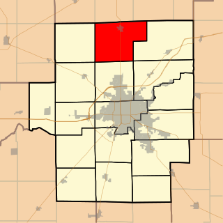
Maroa Township is located in Macon County, Illinois. As of the 2010 census, its population was 2,100 and it contained 883 housing units.
Cisla is a municipality located in the province of Ávila, Castile and León, Spain. According to the 2006 census (INE), the municipality has a population of 175 inhabitants.

Tamariz de Campos is a municipality located in the province of Valladolid, Castile and León, Spain. According to the 2014 census (INE), the municipality has a population of 69 inhabitants.

Hârtiești is a commune in Argeș County, in southern central Romania. It is composed of four villages: Dealu, Hârtiești, Lespezi and Lucieni. It also included the villages of Bârzești, Huluba and Vulturești until 2003, when these were split off to form Vulturești Commune.

Bobiecko is a village in the administrative district of Gmina Łyszkowice, within Łowicz County, Łódź Voivodeship, in central Poland. It lies approximately 10 kilometres (6 mi) south of Łowicz and 44 km (27 mi) north-east of the regional capital Łódź.
Sygneczów is a village in the administrative district of Gmina Wieliczka, within Wieliczka County, Lesser Poland Voivodeship, in southern Poland. It lies approximately 5 kilometres (3 mi) south-west of Wieliczka and 12 km (7 mi) south-east of the regional capital Kraków.

Tarutung is a town in the Tapanuli Utara district and the seat (capital) of North Tapanuli Regency, North Sumatra, Sumatra, Indonesia.
Kiscsécs is a village in Borsod-Abaúj-Zemplén County in northeastern Hungary.
Planaltina do Paraná is a municipality in the state of Paraná in the Southern Region of Brazil.

Tilsi is a village in Põlva Parish, Põlva County in southeastern Estonia.
Bolton Glacier is a glacier flowing into the head of Briand Fjord, Flandres Bay, on the west coast of Graham Land. It was mapped in 1959 by the Falkland Islands Dependencies Survey from photos taken by Hunting Aerosurveys Ltd in 1956–57, and named by the UK Antarctic Place-Names Committee for William B. Bolton (1848–89), English photographer who, with B.J. Sayce, invented the collodion emulsion process of dry-plate photography in 1864.
Kakralaid is an island belonging to the country of Estonia.
Benta is a major town in Lipis District, Pahang, Malaysia.