Radlin is a town in Wodzisław County, Silesian Voivodeship, Poland, with 17,656 inhabitants (2006). Located in southern part of the Voivodeship, close to the Czech border, between 1975 and 1997, Radlin was a district of the city of Wodzisław Śląski.
This is a list of the extreme points of Ireland – the points that are farthest north, south, east or west in Ireland. It includes the Republic of Ireland and Northern Ireland.

Bole is a small town and is the capital of Bole district, a district in the Northern Region of north Ghana. Bole is connected by road to the town of Sawla and the town of Bamboi. Bole is home to the Bole District Hospital and post office. The ex president of Ghana John Dramani Mahama is from this small town.

Zboj is a village and municipality in Snina District in the Prešov Region of north-eastern Slovakia.
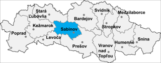
Uzovské Pekľany is a village and municipality in Sabinov District in the Prešov Regionof north-eastern Slovakia.

Liptovské Kľačany is a village and municipality in Liptovský Mikuláš District in the Žilina Region of northern Slovakia.

George Enescu is a commune in Botoșani County, Romania. It is composed of five villages: Arborea, Dumeni, George Enescu, Popeni and Stânca.
San Miguel del Valle is a municipality located in the province of Zamora, Castile and León, Spain. According to the 2004 census (INE), the municipality has a population of 214 inhabitants.
Burrator is a grouped parish council in the English county of Devon. It is entirely within the boundaries of the Dartmoor National Park and was formed from the older councils of Meavy, Sheepstor and Walkhampton.

Stary Toruń is a village in the administrative district of Gmina Zławieś Wielka, within Toruń County, Kuyavian-Pomeranian Voivodeship, in north-central Poland. It lies approximately 9 km (6 mi) west of Toruń.

Siliștea Crucii is a commune in Dolj County, Romania with a population of 1,811 people. It is composed of a single village, Siliștea Crucii.

Hacımahmudlu is a village in the Yevlakh Rayon of Azerbaijan. The village forms part of the municipality of Qaramanlı.
Smardzewice is a village in the administrative district of Gmina Tomaszów Mazowiecki, within Tomaszów Mazowiecki County, Łódź Voivodeship, in central Poland. It lies approximately 4 kilometres (2 mi) south of Tomaszów Mazowiecki and 52 km (32 mi) south-east of the regional capital Łódź.
Fiugajki is a village in the administrative district of Gmina Dąbrówno, within Ostróda County, Warmian-Masurian Voivodeship, in northern Poland. It lies approximately 25 kilometres (16 mi) south of Ostróda and 46 km (29 mi) south-west of the regional capital Olsztyn.
Ciemna Dąbrowa is a village in the administrative district of Gmina Wielbark, within Szczytno County, Warmian-Masurian Voivodeship, in northern Poland. It lies approximately 12 kilometres (7 mi) north-east of Wielbark, 10 km (6 mi) south of Szczytno, and 49 km (30 mi) south-east of the regional capital Olsztyn.
Cherkovo is a village in Karnobat Municipality, in Burgas Province, in southeastern Bulgaria.
Penu is a village in Häädemeeste Parish, Pärnu County in southwestern Estonia. It is the sister city to Vagnu, Latvia.

Gorafe is a municipality in the province of Granada, Spain. As of 2010, it has a population of 474 inhabitants. It has interesting megalithic structures in the area of unknown origin.
Biret Armanaz is a Syrian village located in Armanaz Nahiyah in Harem District, Idlib. According to the Syria Central Bureau of Statistics (CBS), Biret Armanaz had a population of 320 in the 2004 census.