Koundian, Mandiana

Last updated
Koundian
Sub-prefecture and town
Guinea adm location map.svg
Red pog.svg
Koundian
Location in Guinea
Coordinates: 10°55′N8°54′W / 10.917°N 8.900°W / 10.917; -8.900
CountryFlag of Guinea.svg  Guinea
Region Kankan Region
Prefecture Mandiana Prefecture
Population
 (2014)
  Total32,298
Time zone UTC+0 (GMT)

Koundian is a town and sub-prefecture in the Mandiana Prefecture in the Kankan Region of eastern Guinea. [1] As of 2014 it had a population of 32,298 people. [2]

Town settlement that is bigger than a village but smaller than a city

A town is a human settlement. Towns are generally larger than villages but smaller than cities, though the criteria to distinguish them vary considerably between different parts of the world.

Sub-prefectures of Guinea

The sub-prefectures are the third-level administrative divisions in Guinea. As of 2009 there were 303 rural sub-prefectures of Guinea and 38 urban sub-prefectures, 5 of which compose the Conakry greater urban area; Kaloum, Dixinn, Matam, Ratoma and Matoto.

Mandiana Prefecture Prefecture in Kankan Region, Guinea

Mandiana is a prefecture located in the Kankan Region of Guinea. The capital is Mandiana. The prefecture covers an area of 12,825 km.² and has a population of 335,999.

Related Research Articles

Télimélé Place in Kindia Region, Guinea


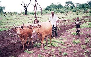
Télimélé is a town in the Fouta Djallon highlands of Guinea. Its population was estimated at 15,973 in 2008. It is the capital of Télimélé Prefecture.

Koba-Tatema Sub-prefecture and town in Boké Region, Guinea

Koba-Tatema is a town and sub-prefecture in the Boffa Prefecture in the Boké Region of western Guinea. As of 2014 it had a population of 50,644 people.

Hérémakonon Sub-prefecture and town in Faranah Region, Guinea

Hérémakonon is a town and sub-prefecture in the Faranah Prefecture in the Faranah Region of Guinea. As of 2014 it had a population of 12,890 people.

Kassadou Sub-prefecture and town in Nzérékoré Region, Guinea

Kassadou is a town and sub-prefecture in the Guéckédou Prefecture in the Nzérékoré Region of south-western Guinea.

Sabadou-Baranama Sub-prefecture and town in Kankan Region, Guinea

Sabadou-Baranama is a town and sub-prefecture in the Kankan Prefecture in the Kankan Region of eastern Guinea. As of 2014 it had a population of 23,159 people.

Kondiadou Sub-prefecture and town in Faranah Region, Guinea

Kondiadou or Koundiatou is a town and sub-prefecture in the Kissidougou Prefecture in the Faranah Region of Guinea. As of 2014 it had a population of 14,897 people.

Yendé-Millimou Sub-prefecture and town in Faranah Region, Guinea

Yendé-Millimou is a sub-prefecture in the Kissidougou Prefecture in the Faranah Region of Guinea. It includes the settlements of Yendé and Millimou. As of 2014 it had a population of 20,372 people.

Damaro Sub-prefecture and town in Kankan Region, Guinea

Damaro is a town and sub-prefecture in the Kérouané Prefecture in the Kankan Region of south-eastern Guinea. As of 2014 it had a population of 27,422 people.

Gama, Guinea Sub-prefecture and town in Nzérékoré Region, Guinea

Gama, Guinea is a town and sub-prefecture in the Lola Prefecture in the Nzérékoré Region of south-eastern Guinea.

Kokota Sub-prefecture and town in Nzérékoré Region, Guinea

Kokota is a town and sub-prefecture in the Lola Prefecture in the Nzérékoré Region of south-eastern Guinea.

Koyamah Sub-prefecture and town in Nzérékoré Region, Guinea

Koyamah is a town and sub-prefecture in the Macenta Prefecture in the Nzérékoré Region of south-eastern Guinea.

Fougou Sub-prefecture and town in Labé Region, Guinea

Fougou, Guinea is a town and sub-prefecture in the Mali Prefecture in the Labé Region of northern Guinea.

Dialakoro, Kankan Sub-prefecture and town in Kankan Region, Guinea

Dialakoro is a town and sub-prefecture in the Mandiana Prefecture in the Kankan Region of eastern Guinea. As of 2014 it had a population of 63,159 people.

Faralako Sub-prefecture and town in Kankan Region, Guinea

Faralako is a town and sub-prefecture in the Mandiana Prefecture in the Kankan Region of eastern Guinea. As of 2014 it had a population of 24,371 people.

Kantoumania Sub-prefecture and town in Kankan Region, Guinea

Kantoumania is a town and sub-prefecture in the Mandiana Prefecture in the Kankan Region of eastern Guinea. As of 2014 it had a population of 11,522 people.

Morodou Sub-prefecture and town in Kankan Region, Guinea

Morodou is a town and sub-prefecture in the Mandiana Prefecture in the Kankan Region of eastern Guinea. As of 2014 it had a population of 28,140 people.

Niantania Sub-prefecture and town in Kankan Region, Guinea

Niantania is a town and sub-prefecture in the Mandiana Prefecture in the Kankan Region of eastern Guinea. As of 2014 it had a population of 14,884 people.

Saladou Sub-prefecture and town in Kankan Region, Guinea

Saladou is a town and sub-prefecture in the Mandiana Prefecture in the Kankan Region of eastern Guinea. As of 2014 it had a population of 18,314 people.

Dongol-Touma Sub-prefecture and town in Mamou Region, Guinea

Dongol-Maci is a town and sub-prefecture in the Pita Prefecture in the Mamou Region of northern-central Guinea.

Maci, Guinea Sub-prefecture and town in Mamou Region, Guinea

Maci is a town and sub-prefecture in the Pita Prefecture in the Mamou Region of northern-central Guinea.

References

  1. "Subprefectures of Guinea". Statoids. Retrieved April 19, 2009.
  2. "Guinea". Institut National de la Statistique, Guinea, accessed via Geohive. Archived from the original on 24 November 2015. Retrieved 12 September 2014.

Coordinates: 10°55′N8°54′W / 10.917°N 8.900°W / 10.917; -8.900

Geographic coordinate system Coordinate system

A geographic coordinate system is a coordinate system that enables every location on Earth to be specified by a set of numbers, letters or symbols. The coordinates are often chosen such that one of the numbers represents a vertical position and two or three of the numbers represent a horizontal position; alternatively, a geographic position may be expressed in a combined three-dimensional Cartesian vector. A common choice of coordinates is latitude, longitude and elevation. To specify a location on a plane requires a map projection.