Morodou

Last updated
Morodou
Sub-prefecture and town
Guinea adm location map.svg
Red pog.svg
Morodou
Location in Guinea
Coordinates: 10°51′N8°40′W / 10.850°N 8.667°W / 10.850; -8.667
CountryFlag of Guinea.svg  Guinea
Region Kankan Region
Prefecture Mandiana Prefecture
Population (2014)
  Total 28,140
Time zone GMT (UTC+0)

Morodou is a town and sub-prefecture in the Mandiana Prefecture in the Kankan Region of eastern Guinea. [1] As of 2014 it had a population of 28,140 people. [2]

Town settlement that is bigger than a village but smaller than a city


A town is a human settlement. Towns are generally larger than villages but smaller than cities, though the criteria to distinguish them vary considerably between different parts of the world.

Sub-prefectures of Guinea

The sub-prefectures are the third-level administrative divisions in Guinea. As of 2009 there were 303 rural sub-prefectures of Guinea and 38 urban sub-prefectures, 5 of which compose the Conakry greater urban area; Kaloum, Dixinn, Matam, Ratoma and Matoto.

Mandiana Prefecture Prefecture in Kankan Region, Guinea

Mandiana is a prefecture located in the Kankan Region of Guinea. The capital is Mandiana. The prefecture covers an area of 12,825 km.² and has a population of 335,999.

Related Research Articles

Banko, Guinea Sub-prefecture and town in Faranah Region, Guinea

Banko is a town and sub-prefecture in the Dabola Prefecture in the Faranah Region of Guinea. As of 2014 it had a population of 23,638 people.

Konindou Sub-prefecture and town in Faranah Region, Guinea

Konindou is a town and sub-prefecture in the Dabola Prefecture in the Faranah Region of Guinea. As of 2014 it had a population of 10,006 people.

Beindou, Faranah Sub-prefecture and town in Faranah Region, Guinea

Beindou is a town and sub-prefecture in the Faranah Prefecture in the Faranah Region of Guinea. As of 2014 it had a population of 16,521 people.

Bolodou Sub-prefecture and town in Nzérékoré Region, Guinea

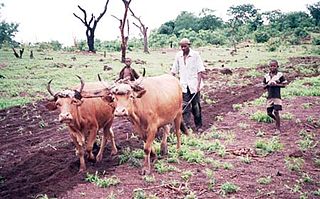
Bolodou is a town and sub-prefecture in the Guéckédou Prefecture in the Nzérékoré Region of south-western Guinea. The sub-prefecture had a population of 13,643 people in 2014, up from 11,750 in 1996. The town itself holds 94 houses with an unknown total population. The Bolodou Sub-Prefecture is divided into 7 quarters (districts), which are: Beddou, Bolodou Centre, Faindou, Gbandou, Koleadou, Kongoma, and Soumtou. Each of these towns can further be split into sectors, which are the smallest administrative divisions in Guinea. In 2017, a local math teacher set up his own dam to generate hydroelectric power for the town's homes. In December 2017, a 27-meter long bridge was built that connected the previously separate markets in Yèndè Millimou and Guéckédou.

Sabadou-Baranama Sub-prefecture and town in Kankan Region, Guinea

Sabadou-Baranama is a town and sub-prefecture in the Kankan Prefecture in the Kankan Region of eastern Guinea. As of 2014 it had a population of 23,159 people.

Kondiadou Sub-prefecture and town in Faranah Region, Guinea

Kondiadou or Koundiatou is a town and sub-prefecture in the Kissidougou Prefecture in the Faranah Region of Guinea. As of 2014 it had a population of 14,897 people.

Yendé-Millimou Sub-prefecture and town in Faranah Region, Guinea

Yendé-Millimou is a sub-prefecture in the Kissidougou Prefecture in the Faranah Region of Guinea. It includes the settlements of Yendé and Millimou. As of 2014 it had a population of 20,372 people.

Koumana Sub-prefecture and town in Kankan Region, Guinea

Koumana is a town and sub-prefecture in the Kouroussa Prefecture in the Kankan Region of eastern-central Guinea. As of 2014 it had a population of 12,789 people.

Lafou Sub-prefecture and town in Labé Region, Guinea

Lafou is a town and sub-prefecture in the Lélouma Prefecture in the Labé Region of northern-central Guinea.

Manda, Guinea Sub-prefecture and town in Labé Region, Guinea

Manda, Guinea is a town and sub-prefecture in the Lélouma Prefecture in the Labé Region of northern-central Guinea.

Sagalé Sub-prefecture and town in Labé Region, Guinea

Sagalé is a town and sub-prefecture in the Lélouma Prefecture in the Labé Region of northern-central Guinea.

Faralako Sub-prefecture and town in Kankan Region, Guinea

Faralako is a town and sub-prefecture in the Mandiana Prefecture in the Kankan Region of eastern Guinea. As of 2014 it had a population of 24,371 people.

Kantoumania Sub-prefecture and town in Kankan Region, Guinea

Kantoumania is a town and sub-prefecture in the Mandiana Prefecture in the Kankan Region of eastern Guinea. As of 2014 it had a population of 11,522 people.

Koundian, Mandiana Sub-prefecture and town in Kankan Region, Guinea

Koundian is a town and sub-prefecture in the Mandiana Prefecture in the Kankan Region of eastern Guinea. As of 2014 it had a population of 32,298 people.

Niantania Sub-prefecture and town in Kankan Region, Guinea

Niantania is a town and sub-prefecture in the Mandiana Prefecture in the Kankan Region of eastern Guinea. As of 2014 it had a population of 14,884 people.

Saladou Sub-prefecture and town in Kankan Region, Guinea

Saladou is a town and sub-prefecture in the Mandiana Prefecture in the Kankan Region of eastern Guinea. As of 2014 it had a population of 18,314 people.

Ouré-Kaba Sub-prefecture and town in Mamou Region, Guinea

Ouré-Kaba is a town and sub-prefecture in the Mamou Prefecture in the Mamou Region of Guinea.

Ninguélandé Sub-prefecture and town in Mamou Region, Guinea

Ninguélandé is a town and sub-prefecture in the Pita Prefecture in the Mamou Region of northern-central Guinea.

Sangaréah Sub-prefecture and town in Mamou Region, Guinea

Sangaréah is a town and sub-prefecture in the Pita Prefecture in the Mamou Region of northern-central Guinea.

References

  1. "Subprefectures of Guinea". Statoids. Retrieved April 19, 2009.
  2. "Guinea". Institut National de la Statistique, Guinea, accessed via Geohive. Retrieved 12 September 2014.

Coordinates: 10°51′N08°40′W / 10.850°N 8.667°W / 10.850; -8.667

Geographic coordinate system Coordinate system

A geographic coordinate system is a coordinate system that enables every location on Earth to be specified by a set of numbers, letters or symbols. The coordinates are often chosen such that one of the numbers represents a vertical position and two or three of the numbers represent a horizontal position; alternatively, a geographic position may be expressed in a combined three-dimensional Cartesian vector. A common choice of coordinates is latitude, longitude and elevation. To specify a location on a plane requires a map projection.