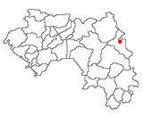
Siguiri is a city in northeastern Guinea on the River Niger. It is a sub-prefecture and capital of Siguiri Prefecture in the Kankan Region. Its population was estimated at 28,319 in 2008.
Mandiana is a prefecture located in the Kankan Region of Guinea. The capital is Mandiana. The prefecture covers an area of 12,825 km.² and has a population of 335,999.

SEMAFO Inc. was a Canadian-based mining company with gold production and exploration activities in West Africa until 2020 when it was acquired by Endeavour Mining. The name SEMAFO is an acronym for "Mining Exploration Society in West Africa". Its headquarters were based in Montreal, Canada. The corporation owned and operated the Mana Mine in Burkina Faso, the third-largest gold mine in Burkina Faso, and reached commercial production at the Boungou Mine on September 1, 2018. The company was listed on the Toronto stock exchange, as well as on the Nasdaq OMX in Stockholm.

Sanso is a small town and commune in the Cercle of Bougouni in the Sikasso Region of south-western Mali. In 2009 the commune had a population of 22,284.
The West African Craton (WAC) is one of the five cratons of the Precambrian basement rock of Africa that make up the African Plate, the others being the Kalahari craton, Congo craton, Saharan Metacraton and Tanzania Craton. Cratons themselves are tectonically inactive, but can occur near active margins, with the WAC extending across 14 countries in Western African, coming together in the late Precambrian and early Palaeozoic eras to form the African continent. It consists of two Archean centers juxtaposed against multiple Paleoproterozoic domains made of greenstone belts, sedimentary basins, regional granitoid-tonalite-trondhjemite-granodiorite (TTG) plutons, and large shear zones. The craton is overlain by Neoproterozoic and younger sedimentary basins. The boundaries of the WAC are predominantly defined by a combination of geophysics and surface geology, with additional constraints by the geochemistry of the region. At one time, volcanic action around the rim of the craton may have contributed to a major global warming event.

The Birimian rocks are major sources of gold and diamonds that extend through Ghana, Côte d'Ivoire, Guinea, Mali and Burkina Faso. They are named after the Birim River, one of the main tributaries of the Pra River in Ghana and the country's most important diamond-producing area. Ghana and Mali are the second and third largest producers of gold in Africa, respectively.
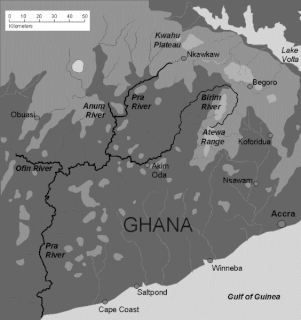
The Birim River is one of the main tributaries of the Pra River in Ghana and the country's most important diamond-producing area, flowing through most of the width of the Eastern region. The river rises in the east of the Atewa Range, flows north through the gap between this range and the Kwahu Plateau, then runs roughly south-west until it joins the Pra. It gives its name to the Birimian rock formation, which yields most of the gold in the region. Ghana is the second largest producer of gold in Africa.
The Man Shield is a geological shield or craton in the southeast portion of the West African Craton. The shield is in part overlaid by gold-bearing Birimian formations.

Faralako is a town and sub-prefecture in the Mandiana Prefecture in the Kankan Region of eastern Guinea. As of 2014 it had a population of 24,371 people.
Kantoumania is a town and sub-prefecture in the Mandiana Prefecture in the Kankan Region of eastern Guinea. As of 2014 it had a population of 11,522 people.
Kiniéran is a town and sub-prefecture in the Mandiana Prefecture in the Kankan Region of eastern Guinea. As of 2014 it had a population of 37,944 people.
Koundianakoro is a town and sub-prefecture in the Mandiana Prefecture in the Kankan Region of eastern Guinea. As of 2014 it had a population of 31,489 people.
Morodou is a town and sub-prefecture in the Mandiana Prefecture in the Kankan Region of eastern Guinea. As of 2014 it had a population of 28,140 people.
Niantania is a town and sub-prefecture in the Mandiana Prefecture in the Kankan Region of eastern Guinea near the border with Mali. As of 2014 it had a population of 14,884 people.
Saladou is a town and sub-prefecture in the Mandiana Prefecture in the Kankan Region of eastern Guinea. As of 2014 it had a population of 18,314 people.
The geology of Burkina Faso is dominated by Precambrian rocks of the Guinea Rise, a dome of Archaean rocks, composed largely of migmatites, gneisses and amphibolites, over which lie the greenstone belts of the early Proterozoic age. The latter are metasediments and metavolcanics assigned largely to the Birimian Supergroup, a suite of rocks in which economically significant mineralization occurs. Pre-Birimian migmatites, gneisses, and amphibolites, located under the Birimian rocks, are the oldest rocks in the country. The Birimian deposits in the southwestern part of the country are typically divided between clastic and volcano-clastic formations.

Geologically, Guinea is covered by a crust of a very large Archean West African Craton with its northern and western regions having formations of younger Proterozoic rocks and its eastern region consists greenstone belts under the Birimian Supergroup which account for a major portion of West Africa's gold and iron ore reserves. Weathering of paleozoïcs schists has resulted in laterisiation leading to the formation of very large bauxite deposits.

The geology of Ghana is primarily very ancient crystalline basement rock, volcanic belts and sedimentary basins, affected by periods of igneous activity and two major orogeny mountain building events. Aside from modern sediments and some rocks formed within the past 541 million years of the Phanerozoic Eon, along the coast, many of the rocks in Ghana formed close to one billion years ago or older leading to five different types of gold deposit formation, which gave the region its former name Gold Coast.
The geology of Niger comprises very ancient igneous and metamorphic crystalline basement rocks in the west, more than 2.2 billion years old formed in the late Archean and Proterozoic eons of the Precambrian. The Volta Basin, Air Massif and the Iullemeden Basin began to form in the Neoproterozoic and Paleozoic, along with numerous ring complexes, as the region experienced events such as glaciation and the Pan-African orogeny. Today, Niger has extensive mineral resources due to complex mineralization and laterite weathering including uranium, molybdenum, iron, coal, silver, nickel, cobalt and other resources.

The geology of Senegal formed beginning more than two billion years ago. The Archean greenschist Birimian rocks common throughout West Africa are the oldest in the country, intruded by Proterozoic granites. Basins formed in the interior during the Paleozoic and filled with sedimentary rocks, including tillite from a glaciation. With the rifting apart of the supercontinent Pangaea in the Mesozoic, the large Senegal Basin filled with thick sequences of marine and terrestrial sediments. Sea levels declined in the Eocene forming large phosphate deposits. Senegal is blanketed in thick layers of terrestrial sediments formed in the Quaternary. The country has extensive natural resources, including gold, diamonds, and iron.