Kissidougou is a prefecture located in the Faranah Region of Guinea. The capital is Kissidougou. The prefecture covers an area of 8,300 km.² and has a population of 283,609.

Diassodou is a town and sub-prefecture in the Beyla Prefecture in the Nzérékoré Region of south-eastern Guinea.
Maférinya is a town and sub-prefecture in the Forécariah Prefecture in the Kindia Region of western Guinea.
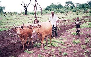
Bolodou is a town and sub-prefecture in the Guéckédou Prefecture in the Nzérékoré Region of south-western Guinea. The sub-prefecture had a population of 13,643 people in 2014, up from 11,750 in 1996. The town itself holds 94 houses with an unknown total population. The Bolodou Sub-Prefecture is divided into 7 quarters (districts), which are: Beddou, Bolodou Centre, Faindou, Gbandou, Koleadou, Kongoma, and Soumtou. Each of these towns can further be split into sectors, which are the smallest administrative divisions in Guinea. In 2017, a local math teacher set up his own dam to generate hydroelectric power for the town's homes. In December 2017, a 27-meter long bridge was built that connected the previously separate markets in Yèndè Millimou and Guéckédou.
Sabadou-Baranama is a town and sub-prefecture in the Kankan Prefecture in the Kankan Region of eastern Guinea. As of 2014 it had a population of 23,159 people.
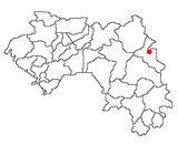
Kondiadou or Koundiatou is a town and sub-prefecture in the Kissidougou Prefecture in the Faranah Region of Guinea. As of 2014 it had a population of 14,897 people.
Yendé-Millimou is a sub-prefecture in the Kissidougou Prefecture in the Faranah Region of Guinea. It includes the settlements of Yendé and Millimou. As of 2014 it had a population of 20,372 people.
Soromaya is a town and sub-prefecture in the Kérouané Prefecture in the Kankan Region of south-eastern Guinea. As of 2014 it had a population of 20,134 people.
Diari, Guinea is a town and sub-prefecture in the Labé Prefecture in the Labé Region of northern-central Guinea.
Dionfo is a town and sub-prefecture in the Labé Prefecture in the Labé Region of northern-central Guinea.
Hérico is a town and sub-prefecture in the Lélouma Prefecture in the Labé Region of northern-central Guinea.
Sagalé is a town and sub-prefecture in the Lélouma Prefecture in the Labé Region of northern-central Guinea.
Faralako is a town and sub-prefecture in the Mandiana Prefecture in the Kankan Region of eastern Guinea. As of 2014 it had a population of 24,371 people.
Kantoumania is a town and sub-prefecture in the Mandiana Prefecture in the Kankan Region of eastern Guinea. As of 2014 it had a population of 11,522 people.
Koundian is a town and sub-prefecture in the Mandiana Prefecture in the Kankan Region of eastern Guinea. As of 2014 it had a population of 32,298 people.
Morodou is a town and sub-prefecture in the Mandiana Prefecture in the Kankan Region of eastern Guinea. As of 2014 it had a population of 28,140 people.
Niantania is a town and sub-prefecture in the Mandiana Prefecture in the Kankan Region of eastern Guinea. As of 2014 it had a population of 14,884 people.
For the river having its source near the town, see Konkouré River
Fouala is a town and sub-prefecture in the Beyla Prefecture in the Nzérékoré Region of south-eastern Guinea.
Tountouroun is a town and sub-prefecture in the Labé Prefecture in the Labé Region of northern-central Guinea.