| |
 | |
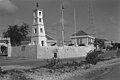
| Location | Bonaire, Kralendijk, Bonaire, Kralendijk, Netherlands |
|---|---|
| Coordinates | 12°08′56″N68°16′37″W / 12.14881°N 68.27681°W |
| Tower | |
| Constructed | 1837 (first) [1] |
| Construction | stone tower [1] |
| Height | 7 metres (23 ft) [2] |
| Shape | square tapered truncated tower with balcony and light [1] |
| Markings | ochre tower |
| Power source | mains electricity |
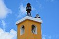
| Light | |
| First lit | 1932 (current) [1] |
| Focal height | 13 metres (43 ft) [2] |
| Range | 5 nautical miles (9.3 km; 5.8 mi) [2] |
| Characteristic | Fl W 2s. [2] |
Kralendijk Lighthouse (or Fort Oranje Lighthouse) is an active lighthouse in the town of Kralendijk, Bonaire, in the Caribbean Netherlands. It was built in 1932 on the grounds of Fort Oranje, a 17th century fort. [3] [4]