Älpelekopf is a mountain with an elevation of 1,606 m (5,269 ft) in the Alps. Älpelekopf has a secondary peak situated on a ridge which runs southwest from Riffenkopf to Schrofen at which point the ridge falls off steeply.

The Alpgundkopf is a mountain, 2,177 m high, in the Allgäu Alps. It lies in the Schafalpenköpfe group, northeast of the Roßgundkopf, from which it is separated by the Alpgundscharte col. To the southeast, 383 metres away, lies the lower Alpkopf and, 1,035 metres away, the small lake of Guggersee.
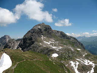
The Bockkarkopf is a mountain, 2,609 m high, and part of the main ridge of the Allgäu Alps. It is the ninth highest peak in the Allgäu Alps and is located between the Wilder Mann to the southwest and the Hochfrottspitze to the northeast. The busy Heilbronn Way runs over the pyramidal peak.

The Giebel is the northeastern corner of the mountain chain that branches off to the northeast at the Laufbacher Eck. It has a height of 1,949 metres and belongs to the Allgäu grass mountains. Northeast of the Giebel lies the Alpine hut of Giebelhaus, which may be reached on a road from Hinterstein that is not open to the public. From the Giebel there are impressive views down to the Giebelhaus.

The Hochfrottspitze is a 2,649-metre-high (8,691 ft) mountain, made of main dolomite, in the Allgäu Alps near Oberstdorf in Germany and the highest German mountain in the Allgäu Alps. The border with Austria runs along its ridge.

The Höfats is a 2,259 m high mountain in the Allgäu Alps. Located near Oberstdorf, it separates the Oy and the Dietersbach valleys, along with the Rauheck and other lower summits. With its very steep faces it is the most striking of the Allgau "grass mountains" (Grasberge) and is unique in the Eastern Alps. It may be compared to the mountains of the Lofoten.

The Laufbacher Eck is a 2,178-metre-high grass mountain in the Allgäu Alps in the south German state of Bavaria.

The Mädelegabel is a 2,645 metre high mountain, made of main dolomite, in the Allgäu Alps near Oberstdorf. It is one of the best-known and most-climbed high peaks in the German Alps, Within the Allgäu Alps it is the fourth-highest summit, with rock faces up to 400 metres high. Together with the Trettachspitze and the Hochfrottspitze it forms the famous triumvirate of peaks on the main crest of the Allgäu. Its name comes from Mähder - a mown mountain pasture in the vicinity - and gabel from the appearance of the triumvirate to the north which recalls a fork. Originally the Mädelegabel was the name for all three peaks of the triumvirate; only later were they distinguished from one another by name.

Mußkopf is a mountain in the Allgäu Alps which are located in Bavaria, Germany. It is a peak above a steep couloir, below the Rappensee Hut alpine hut. There is no marked trail to the peak.

The Salober ist a 2,088 -high grass mountain in the Allgäu Alps. It lies northeast of the Laufbacher Eck.
The First Schafalpenkopf or Southwestern Schafalpenkopf is a 2,272-metre-high mountain in the Allgäu Alps. It is part of the Schafalpenköpfe and the Mindelheim Klettersteig.
The Urbeleskarspitze is a 2,632-metre-high mountain peak in the Allgäu Alps. It lies within Austria in the state of Tyrol and is the fifth-highest summit in the Allgäu Alps and the second-highest peak in the Hornbach chain. Its neighbours in the Hornbach chain are the Bretterspitze to the southwest and the Zwölfer Spitze to the northeast.
The Hornbach chain is a string of mountains, about 15 kilometres long, in the Allgäu Alps in the Austrian state of Tyrol.
The Steinschartenkopf is a rocky peak, 2,615 m, in the Hochlicht range in the Allgäu Alps. It is located between the Wilder Mann to the north and the Hohes Licht to the south and is the sixth highest summit in the Allgäu Alps. The popular Heilbronn Way runs over the summit.

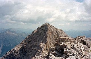
The Marchspitze is a prominent summit, made of main dolomite, in the Hornbach chain of the Allgäu Alps. It is located 1.5 kilometres east of the much better known Großer Krottenkopf and is entirely on Austrian soil.

The Bretterspitze is a 2,608-metre-high summit in the Austrian state of Tyrol. It is part of the Hornbach chain in the Allgäu Alps. Its neighbouring peaks in the Hornbach chain are the Gliegerkarspitze to the west and the Urbeleskarspitze to the northeast. The broad summit block of the Bretterspitze is made of main dolomite.

The Großer Widderstein is a mountain, 2,533 m (AA), in the west Austrian state of Vorarlberg. Topographically it belongs to the Allgäu Alps. It is the highest peak in the subgroup of the Southeastern Walsertal Mountains.

The Schartschrofen is a rocky summit, 1,968 m high, in the Tannheim Mountains, a sub-group of the Allgäu Alps. It lies northwest of the Rote Flüh and south of the col of Füssener Jöchl.

The Kreuzkarspitze is a 2,587-metre-high Austrian mountain in the Hornbach chain of the Allgäu Alps.