Kudayathoor | |
|---|---|
village | |
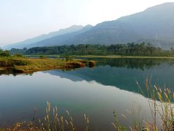 Malankara Dam reservoir from Kudayathoor | |
 Interactive map of Kudayathoor | |
| Coordinates: 9°49′0″N76°47′0″E / 9.81667°N 76.78333°E | |
| Country | |
| State | Kerala |
| District | Idukki |
| Population (2011) | |
• Total | 10,080 |
| Languages | |
| • Official | Malayalam, English |
| Time zone | UTC+5:30 (IST) |
| Vehicle registration | KL-38 |

Kudayathoor is a village in Idukki district [1] which is located along the Thodupuzha-Puliyanmala road in the Indian state of Kerala. [2] Kudayathoor is known for its scenery mostly because of the towering presence of Western ghats on one side.[ citation needed ] A number of Malayalam films have also been shot in this area, including Kunjikoonan , Vasanthiyum Lakshmiyum Pinne Njaanum , Vismayathumbathu , Drishyam , Kadha Parayumbol , Rasathanthram , Aadu , and Vellimoonga . Malankara dam, which is a hydro electric power plant located along Muvattupuzha river, in Muttom, uses this place as its catchment area.