A lighthouse is a tower, building, or other type of physical structure designed to emit light from a system of lamps and lenses and to serve as a beacon for navigational aid, for maritime pilots at sea or on inland waterways.

Southwold Lighthouse is a lighthouse operated by Trinity House in the centre of Southwold in Suffolk, England. It stands on the North Sea coast, acting as a warning light for shipping passing along the east coast and as a guide for vessels navigating to Southwold harbour.

Cuxhaven is a town and seat of the Cuxhaven district, in Lower Saxony, Germany. The town includes the northernmost point of Lower Saxony. It is situated on the shore of the North Sea at the mouth of the Elbe River. Cuxhaven has a footprint of 14 kilometres (east–west) by 7 km (4 mi) (north–south). Its town quarters Duhnen, Döse and Sahlenburg are especially popular vacation spots on the North Sea and home to about 52,000 residents.

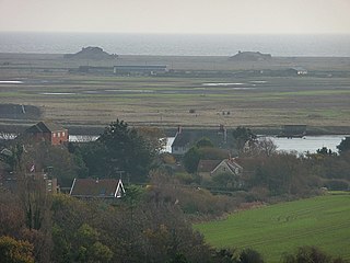
Neuwerk (; is a 3 km2 tidal island in the Wadden Sea a marginal part of North Sea along the German coast. The population in 2023 was 21. Neuwerk is located 13 km northwest of Cuxhaven, between the Weser and Elbe estuaries. The distance to the centre of Hamburg is about 120 km.
A sea mark, also seamark and navigation mark, is a form of aid to navigation and pilotage that identifies the approximate position of a maritime channel, hazard, or administrative area to allow boats, ships, and seaplanes to navigate safely.
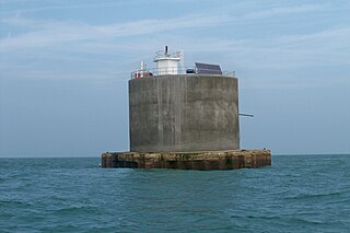
The Nab Tower is a tower originally planned for anti-submarine protection in the English Channel in World War I. It was sunk over the Nab rocks east of the Isle of Wight to replace a lightship after the war, and is a well-known landmark for sailors as it marks the deep-water eastern entry into the Solent.

The Thames Estuary is where the River Thames meets the waters of the North Sea, in the south-east of Great Britain.
Orford Ness is a cuspate foreland shingle spit on the Suffolk coast in Great Britain, linked to the mainland at Aldeburgh and stretching along the coast to Orford and down to North Weir Point, opposite Shingle Street. It is divided from the mainland by the River Alde, and was formed by longshore drift along the coast. The material of the spit comes from places further north, such as Dunwich. Near the middle point of its length, at the foreland point or 'Ness', once stood Orfordness Lighthouse, demolished in summer 2020 owing to the encroaching sea. In the name of the lighthouse, 'Orfordness' is written as one word.

The Macquarie Lighthouse, also known as South Head Upper Light, is the first, and is the longest serving, lighthouse site in Australia. It is located on Dunbar Head, on Old South Head Road, Vaucluse in the Municipality of Woollahra local government area of New South Wales, Australia. The lighthouse is situated approximately 2 kilometres (1 mi) south of South Head near the entrance to Sydney Harbour. There has been a navigational aid in this vicinity since 1791 and a lighthouse near the present site since 1818. The current heritage-listed lighthouse was completed in 1883. The lighthouse and associated buildings were designed by James Barnet and built from 1881 to 1883.

Kõpu Lighthouse is one of the best-known symbols and tourist sites on the Estonian island of Hiiumaa. It is located in the in the village of Mägipe. It is one of the oldest lighthouses in the world, having been in continuous use since its completion in 1531. The lighthouse is quite unique with its shape and exceptional among lighthouses because it has gone through all the stages from a medieval landmark up to a modern electrified lighthouse.
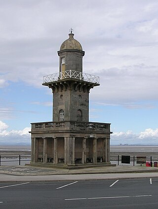
The Beach Lighthouse is a 44-foot (13 m) tall sandstone lighthouse in Fleetwood, Lancashire, England.

The Wyre Light was a 40-foot (12 m) tall iron screw-pile lighthouse marking the navigation channel to the town of Fleetwood, Lancashire, England.

The Low Lighthouse is one of three historic lighthouses in Burnham-on-Sea, Somerset, England, and the only one of the three which is still active. It is a Grade II listed building and stands on the foreshore. First lit in 1832, the Low Lighthouse operated in conjunction with the (onshore) High Lighthouse for 137 years. Then, in 1969 the Low Lighthouse was deactivated; but later, in 1993, the Low Lighthouse was re-established and the High Lighthouse was instead decommissioned).
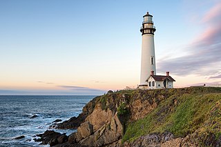
Pigeon Point Light Station or Pigeon Point Lighthouse is a lighthouse built in 1871 to guide ships on the Pacific coast of California. It is the tallest lighthouse on the West Coast of the United States. It is still an active Coast Guard aid to navigation. Pigeon Point Light Station is located on the coastal highway, 5 miles (8 km) south of Pescadero, California, between Santa Cruz and San Francisco. The 115-foot (35 m), white masonry tower, resembles the typical New England structure.
Wharton Reef Light is an inactive lighthouse which used to be located on Wharton Reef in Princess Charlotte Bay off the Cape York Peninsula, Queensland, Australia. When it was deactivated in 1990 it was donated to the Townsville Maritime Museum and it is now on display near the museum. It is the only survivor of a series of twenty automatic lighthouses installed in Queensland during the "Golden Age of Australian Lighthouses" from 1913 to the early 1920s.

Heligoland Lighthouse is located on Germany's only offshore island, Heligoland. Constructed during World War II as an anti-aircraft tower, it was turned into a lighthouse in 1952. It features the strongest light on the German North Sea coast with a range of 28 nautical miles (52 km) so that it can be seen as far as on the East Frisian or the North Frisian islands and Halligen. The lighthouse is operated by the Tönning water and shipping authority.

Black Nore Lighthouse at Portishead, Somerset, England, was built in 1894. It is a Grade II listed building.

Lowestoft Lighthouse is a lighthouse operated by Trinity House located to the north of the centre of Lowestoft in the English county of Suffolk. It stands on the North Sea coast close to Ness Point, the most easterly point in the United Kingdom. It acts as a warning light for shipping passing along the east coast and is the most easterly lighthouse in the UK.
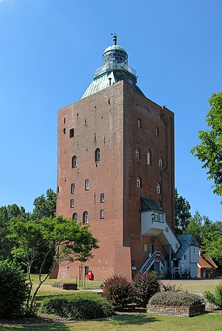
The Great Tower Neuwerk is the most significant building of the Neuwerk island, belonging to Hamburg. Completed in 1310, the structure is one of the oldest worldwide that was used as lighthouse (1814–2014) and still standing. This former beacon, watchtower and lighthouse is also the oldest building in Hamburg and oldest secular building on the German coast.

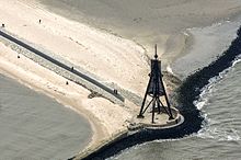
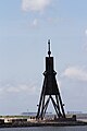
The Scharhörnbake was the most important daymark on the German North Sea coast for several centuries. First erected in 1661 by the City of Hamburg on the sandbank Scharhörn and south side of the Elbe estuary, it was rebuilt over centuries and taken down finally in 1979. Equipped with a room, it also functioned as a refuge beacon for shipwreck survivors from 1840 to 1965. The only remaining element today is the boulder stone foundation near Nigehörn.