
Navigation is a field of study that focuses on the process of monitoring and controlling the movement of a craft or vehicle from one place to another. The field of navigation includes four general categories: land navigation, marine navigation, aeronautic navigation, and space navigation.

A compass is a device that shows the cardinal directions used for navigation and geographic orientation. It commonly consists of a magnetized needle or other element, such as a compass card or compass rose, which can pivot to align itself with magnetic north. Other methods may be used, including gyroscopes, magnetometers, and GPS receivers.
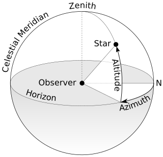
An azimuth is the horizontal angle from a cardinal direction, most commonly north, in a local or observer-centric spherical coordinate system.

North is one of the four compass points or cardinal directions. It is the opposite of south and is perpendicular to east and west. North is a noun, adjective, or adverb indicating direction or geography.

In navigation, a rhumb line, rhumb, or loxodrome is an arc crossing all meridians of longitude at the same angle, that is, a path with constant azimuth . Navigation on a fixed course would result in a rhumb-line track.
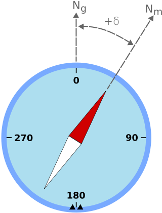
Magnetic declination is the angle between magnetic north and true north at a particular location on the Earth's surface. The angle can change over time due to polar wandering.

A non-directional beacon (NDB) or non-directional radio beacon is a radio beacon which does not include inherent directional information. Radio beacons are radio transmitters at a known location, used as an aviation or marine navigational aid. NDB are in contrast to directional radio beacons and other navigational aids, such as low-frequency radio range, VHF omnidirectional range (VOR) and tactical air navigation system (TACAN).

An automatic direction finder (ADF) is a marine or aircraft radio-navigation instrument that automatically and continuously displays the relative bearing from the ship or aircraft to a suitable radio station. ADF receivers are normally tuned to aviation or marine NDBs operating in the LW band between 190 – 535 kHz. Like RDF units, most ADF receivers can also receive medium wave (AM) broadcast stations, though these are less reliable for navigational purposes.
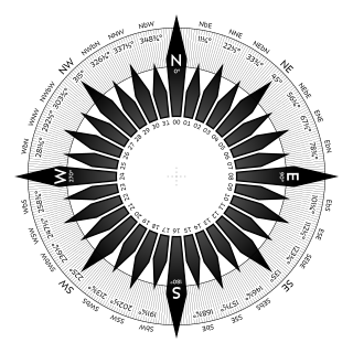
The points of the compass are a set of horizontal, radially arrayed compass directions used in navigation and cartography. A compass rose is primarily composed of four cardinal directions—north, east, south, and west—each separated by 90 degrees, and secondarily divided by four ordinal (intercardinal) directions—northeast, southeast, southwest, and northwest—each located halfway between two cardinal directions. Some disciplines such as meteorology and navigation further divide the compass with additional azimuths. Within European tradition, a fully defined compass has 32 "points".
Piloting or pilotage is the process of navigating on water or in the air using fixed points of reference on the sea or on land, usually with reference to a nautical chart or aeronautical chart to obtain a fix of the position of the vessel or aircraft with respect to a desired course or location. Horizontal fixes of position from known reference points may be obtained by sight or by radar. Vertical position may be obtained by depth sounder to determine depth of the water body below a vessel or by altimeter to determine an aircraft's altitude, from which its distance above the ground can be deduced. Piloting a vessel is usually practiced close to shore or on inland waterways. Pilotage of an aircraft is practiced under visual meteorological conditions for flight.
A lubber line, also known as a lubber's line, is a fixed line on a compass binnacle or radar plan position indicator display pointing towards the front of the ship or aircraft and corresponding to the craft's centerline.
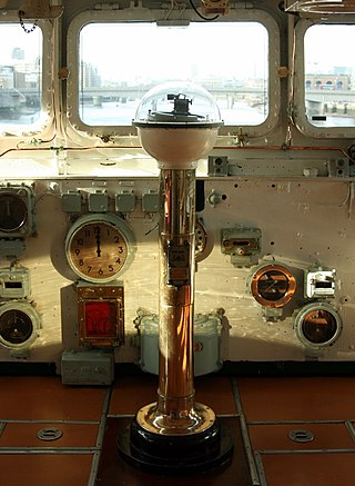
In marine navigation, a pelorus is a reference tool for maintaining bearing of a vessel at sea. It is a "simplified compass" without a directive element, suitably mounted and provided with vanes to permit observation of relative bearings.
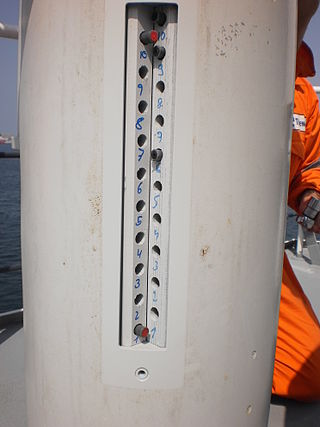
Magnetic deviation is the error induced in a compass by local magnetic fields, which must be allowed for, along with magnetic declination, if accurate bearings are to be calculated.

Diver navigation, termed "underwater navigation" by scuba divers, is a set of techniques—including observing natural features, the use of a compass, and surface observations—that divers use to navigate underwater. Free-divers do not spend enough time underwater for navigation to be important, and surface supplied divers are limited in the distance they can travel by the length of their umbilicals and are usually directed from the surface control point. On those occasions when they need to navigate they can use the same methods used by scuba divers.
Position resection and intersection are methods for determining an unknown geographic position by measuring angles with respect to known positions. In resection, the one point with unknown coordinates is occupied and sightings are taken to the known points; in intersection, the two points with known coordinates are occupied and sightings are taken to the unknown point.

A clock position, or clock bearing, is the direction of an object observed from a vehicle, typically a vessel or an aircraft, relative to the orientation of the vehicle to the observer. The vehicle must be considered to have a front, a back, a left side and a right side. These quarters may have specialized names, such as bow and stern for a vessel, or nose and tail for an aircraft. The observer then measures or observes the angle made by the intersection of the line of sight to the longitudinal axis, the dimension of length, of the vessel, using the clock analogy.

In navigation, the heading of a vessel or aircraft is the compass direction in which the craft's bow or nose is pointed. Note that the heading may not necessarily be the direction that the vehicle actually travels, which is known as its course. Any difference between the heading and course is due to the motion of the underlying medium, the air or water, or other effects like skidding or slipping. The difference is known as the drift, and can be determined by the wind triangle. At least seven ways to measure the heading of a vehicle have been described. Heading is typically based on cardinal directions, so 0° indicates a direction toward true north, 90° true east, 180° true south, and 270° true west.
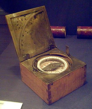
An azimuth compass is a nautical instrument used to measure the magnetic azimuth, the angle of the arc on the horizon between the direction of the Sun or some other celestial object and the magnetic north. This can be compared to the true azimuth obtained by astronomical observation to determine the magnetic declination, the amount by which the reading of a ship's compass must be adjusted to obtain an accurate reading. Azimuth compasses were important in the period before development of the reliable chronometers needed to determine a vessel's exact position from astronomical observations.

A prismatic compass is a navigation and surveying instrument which is extensively used to find out the bearing of the traversing and included angles between them, waypoints and direction. Compass surveying is a type of surveying in which the directions of surveying lines are determined with a magnetic compass, and the length of the surveying lines are measured with a tape or chain or laser range finder. The compass is generally used to run a traverse line. The compass calculates bearings of lines with respect to magnetic needle. The included angles can then be calculated using suitable formulas in case of clockwise and anti-clockwise traverse respectively. For each survey line in the traverse, surveyors take two bearings that is fore bearing and back bearing which should exactly differ by 180° if local attraction is negligible. The name Prismatic compass is given to it because it essentially consists of a prism which is used for taking observations more accurately.
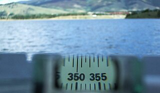
A bearing compass, is a nautical instrument used to determine the bearing of observed objects.. Used in navigation to determine the angle between the direction of an object and the magnetic north or, indirectly relative to another reference point. Provides the absolute bearing, which is the clockwise angle between magnetic north or true north and the object. For example, an object to the east would have an absolute bearing of 90º, if it is relative to the magnetic north than it is called magnetic bearing. It is commonly used by geologists and surveyors to obtain precise bearings on the ground.


