
Osmanabad, officially known as Dharashiv, is a city and a municipal council in Osmanabad district in the Indian state of Maharashtra. The city is the administrative headquarter of Osmanabad district. It is the seventh largest city in Marathwada, and the 39th largest city in Maharashtra by population.
Kannad is a Taluka and a Municipal Council City in Aurangabad District in the Indian state of Maharashtra. Kannad has located 58 km from Aurangabad. It is located 24 km away from the Ellora Caves and Grishneshwar Temple. It is 45 Km from Daulatabad / Deogiri Fort.
Kurduvadi is Big Railway Junction in Solapur district in Maharashtra state of India. It is situated on Barshi Light Railway It is known mainly for the railway junction connecting two different rail tracks. Prior to gauge conversion it used to be a junction with different size gauge tracks.
Adavad, also spelled Adawad or Adwad, is a village in the Chopda Tehsil of Jalgaon District, Maharashtra, India. It is situated at the southern base of the Satpura Hills, about 30 kilometres northwest of the district seat Jalgaon, and 13 kilometres east of the subdistrict seat Chopda. As of the year 2011, it has a total population of 24,357.

Wandoor is a town in Nilambur Taluk, Malappuram District, Kerala, India. It is located on the southeast of Chaliyar River, about 24 kilometres northeast of the district seat Malappuram, and 8 km south of the taluk seat Nilambur. In the year 2011, the town has a population of 50,973.
Nandnee, also spelleda as Nandani, is a village in the Solapur district in Pune division of Desh region of Maharashtra state in India.
Gevrai or Georai is a tehsil in the Beed district of Maharashtra, India.
Hotgi is a village located in South Solapur, within the district of Solapur in the Indian state of Maharashtra. This village holds historical significance and boasts various landmarks and cultural attractions that make it a notable destination in the region.

Thevalakkara is a village in the Karunagappally Taluk, Kollam District of the state of Kerala, India. It is located near the coast of the Indian Ocean, about 13 kilometres north of the district capital Kollam, and 7 kilometres southeast of the subdistrict capital Karunagappally. It contains a Devi temple along with a church and a mosque. The kadappa at Thevalakara is where ship masts (kadappa) were made for centuries. In 2011, it has a total population of 42,977.
Chinchali is a village in Raybag Taluk, Belagavi District, Karnataka, India. It is located near the state boundary with Maharashtra, approximately 84 kilometres north of the district seat Belgaum, and 10 kilometres northeast of the taluk seat Raibag. In the year 2011, the village has a population of 18,986.
Chadchan is a taluq in the southern state of Karnataka, India. It is located in Vijayapura district in northern part of Karnataka.
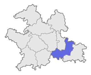
Solapur South Taluka is one of the 11 tehsils of Solapur District in the Indian state of Maharashtra. This tehsil is located in the southeastern side of district and is bordered by Osmanabad District to the northeast, North Solapur and Mohol Taluka to the north, Akkalkot Taluka to the southeast, Karnataka's Kalaburagi district to the south, and Mangalvedhe Taluka to the west. The tehsil headquarters is located at Solapur, which is also the district headquarters and its largest city. Mandrup, Kumbhari, Valasang, Musti and Boramani are the biggest villages in south Solapur.
Mohare is a village in Bailhongal Taluk, Belagavi District of Karnataka, India. It is located near the state border with Maharashtra, about 26 kilometres east of the district seat Belgaum, and 16 kilometres northwest of the taluk seat Bailhongal. As of 2011, it has a total population of 2,365.
Pimpalgaon Baswant is a town in Niphad Taluk, Nashik District, Maharashtra, India. It is located to the north of Kadva River, about 28 kilometres northeast of the district capital Nashik, and 16 kilometres northwest of the taluk capital Niphad. In the year 2011, it is home to 41,559 inhabitants.
Yenegur is a major village located in Omerga tehsil of Osmanabad district, which is part of the Marathwada region of the state of Maharashtra in India.
Ganeshwadi is a small village located in Mangalwedha taluka of Solapur district in the state of Maharashtra, in India.
Badavanahalli is a village within Madhugiri Taluk, Tumakuru District, Karnataka, India. It is located at 37 kilometres north of the district seat Tumkur, and 16 kilometres west of the subdistrict seat Madhugiri. In the year 2011, it has a total population of 4,332.
Fursungi, or Phursungi, is a town in Haveli Taluka, Pune District, Maharashtra, India. It is located on the south of Mula-Mutha River, approximately 13 kilometres east of the district capital Pune, and 9 kilometres southeast of the taluka seat Haveli. Like other settlements in this area, Fursungi is under the administration of Pune Municipal Corporation. At the end of 2011, it is home to 66,062 inhabitants.

Palavoor is a village in Radhapuram Taluk, Tirunelveli District, Tamil Nadu, India. It is located near the coast of the Indian Ocean, about 60 kilometres south of the district seat Tirunelveli, and 14 kilometres southwest of the taluk seat Radhapuram. In 2011, the village had a total population of 17,780.
Ganga Parshad is a village in the suburb of Sahibganj, Sahibganj District, Jharkhand, India. It is located near the state border with Bihar, about 6 kilometres west of the urban center of Sahebganj. In 2011, it had a population of 24,844.

