
Chandrapur district is a district in the Nagpur Division in the Indian state of Maharashtra. Chandrapur was the largest district in India until the Gadchiroli and Sironcha tehsils were separated as Gadchiroli district in 1981. In 2011, the district population was 2,204,307.
Beed district is an administrative district in the state of Maharashtra in India. The district headquarters are located at Beed. The district occupies an area of 10,693 km² and has a population of 2,585,049 of which 17.91% were urban.
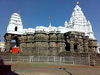
Hingoli district is an administrative district in the state of Maharashtra in India. The district is headquartered at Hingoli. The district occupies an area of 4,526 km2 and has a population of 11,77,345 of which 15.60% were urban. Hingoli was actually known as the Nizams military base as it was bordered with Vidharbha. In that era military troops, hospitals, veterinary hospital were in operation from Hingoli. Being a military base the city was one of the important and famous places of the Hyderabad state. One of the twelve Jyotirlinga shrines, the Aundha Nagnath is located in Hingoli district about 25 km south-west from district headquarter.

Osmanabad District officially known as Dharashiv District is an administrative district in the Marathwada region in the Indian state of Maharashtra. The district headquarter is located at Osmanabad. The District of Osmanabad derives its name from the last ruler of Hyderabad, the 7th Nizam, Mir Osman Ali Khan, of which the region was a part till 1947. This region was earlier part of The Hyderabad State until Independence.This primarily rural district occupies an area of 7,569 km2 (2,922 sq mi) of which 241.4 km2 (93.2 sq mi) is urban and has a population of 1,657,576 of which 16.96% were urban.

Narmada district is an administrative district in the state of Gujarat in India. The district headquarters are located at Rajpipla. The district is bounded by Vadodara and Chhota Udaipur districts in the north, by Nandurbar district of Maharashtra state in the east, by Surat and Tapi districts in the south and by Bharuch district in the west. The district occupies an area of 2,755 km² and has a population of 590,297. It was 10.44% urban as of 2011. As of 2011, it is the third least populous district of Gujarat, after Dang and Porbandar.

Washim district is a district in Maharashtra, India. The headquarters is at Washim. The area of the district is 5,150 km2 (1,990 sq mi).

Akola district is a district in the Indian state of Maharashtra. The city of Akola is the district headquarters. Akola district forms the central part of Amravati Division, which was the former British Raj Berar Province.
Pune Division is one of the six administrative divisions of the Indian State of Maharashtra. Pune Division is bound by Konkan Division to the west, Nashik Division to the north, Aurangabad Division to the east, and the state of Karnataka to the south.
Nanded district is a district of Maharashtra state in central India. The city of Nanded is the district headquarters.

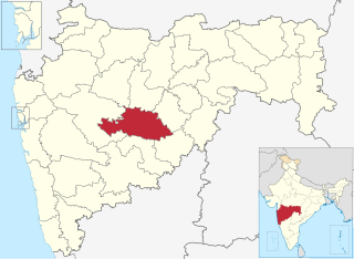
Sangli district is a district of Maharashtra state in India. Sangli city is the district headquarters. It is bordered by Satara district, Solapur district to the North, Karnataka state to the South-East, by Kolhapur district to South-West and by narrow portion on the East side to Ratnagiri district. It is present on the southern tip of Maharashtra.

Kalaburagi district, formerly known as Gulbarga district, is one of the 31 districts of Karnataka state in southern India. Kalaburagi city is the administrative headquarters of the district. The district is the headquarters of Kalaburagi division.

Solapur District is a district in Maharashtra state of India. The city of Solapur is the district headquarters. It is located on the south east edge of the state and lies entirely in the Bhima and Seena basins. The entire district is drained by the Bhima River.
Jat is a town and taluka headquarters in Miraj subdivision of Sangli district in southern Maharashtra.
Khanapur (Vita) is a village and taluka and a subdivision of Sangli district of Maharashtra in India.
Kadegaon is a village and taluka of Sangli district of Maharashtra in India.
Atpadi is a taluka in Sangli district of Maharashtra, in 2022 it is one of the talukas of the district, belonging to the Vita sub-division of the district. In 2012 the taluka suffered a severe drought, reportedly the worst in living memory, similar conditions were faced in 2016 and 2019, in 2020 the taluka was hit by floods that caused losses to lives and properties. India's best quality pomegranates are grown in the taluka and the taluka is a pioneer amongst exporters of the fruit, though adverse climatic conditions and diseases have hit the growers. There is a proposal and demand that Sangli district be split to form a new Mandesh district, with Atpadi taluka being one of the talukas to be included in this new district.

Barshi Taluka is one of the 11 tehsils of Solapur District in the Indian state of Maharashtra. This tehsil occupies the Northeast corner of the district and is bordered by Osmanabad District to the north and east, Madha Taluka to the west, Mohol Taluka to the southwest and North Solapur Taluka to the south. The tehsil headquarters is located at Barshi, which is also the largest city in the tehsil.

Karmala Taluka is one of the 11 talukas of Solapur district in the Indian state of Maharashtra. Parts of the movie Sairat were shot in this taluka. Its headquarters are in the town of Karmala.
Mahur taluka is a taluka in Nanded district of Maharashtra an Indian state. Its headquarters are at Mahur.
Dharni is a taluka in Amravati district, Maharashtra. It lies in the Satpura Range and is heavily forested and mainly tribal. Its headquarters are at Dharni. Melghat Tiger Reserve is part of this taluk.

