Gökbelen is a neighbourhood in the municipality and district of Silifke, Mersin Province, Turkey. Its population is 181 (2022). Its distance to Silifke is 28 kilometres (17 mi) and to Mersin is 123 kilometres (76 mi). In summers the population increases for the village is used as a summer resort by some Silifke and Taşucu residents..
Arkum is a neighbourhood in the municipality and district of Silifke, Mersin Province, Turkey. Its population is 1,737 (2022). Before the 2013 reorganisation, it was a town (belde).

Akdere is a neighbourhood in the municipality and district of Silifke, Mersin Province, Turkey. Its population is 1,268 (2022). Before the 2013 reorganisation, it was a town (belde).

Balandız (Gümüşlü) is a neighbourhood in the municipality and district of Silifke, Mersin Province, Turkey. Its population is 170 (2022). It is situated in the Taurus Mountains. It is 22 kilometres (14 mi) from Silifke and 105 kilometres (65 mi) from Mersin. Balandız is an agricultural village. But during summers it is also a yayla (resort). Now an unused building is under renovation to be put into service as a village museum and a library.
Burunucu is a neighbourhood in the municipality and district of Silifke, Mersin Province, Turkey. Its population is 865 (2022). The village is situated on the state highway D.400, almost at the midpoint between Silifke and Taşucu, the distance to both being about 5 kilometres (3.1 mi). It is 86 kilometres (53 mi) from Mersin.
Keben is a neighbourhood in the municipality and district of Silifke, Mersin Province. Its population is 557 (2022). Distance to Silifke is 18 kilometres (11 mi) and to Mersin is 105 kilometres (65 mi). It is situated to the north of Turkish state highway D.715 and Göksu River. The village is famous for its main crop, namely pomegranate. This product is now proposed to be officially registered as pomegranate of Keben. Another important product is plum.

Cambazlı is a neighbourhood in the municipality and district of Silifke, Mersin Province, Turkey. Its population is 686 (2022).
Gülümpaşalı is a neighbourhood in the municipality and district of Silifke, Mersin Province, Turkey. Its population is 395 (2022). The village is situated in the coastal plain of Silifke about 3 kilometres (1.9 mi) north of the Mediterranean Sea coast and to the south of Turkish state highway D.400 connecting Mersin to Antalya. The distance to Silifke is 7 kilometres (4.3 mi) and to Mersin is 92 kilometres (57 mi).
Bayındır is a neighbourhood in the municipality and district of Silifke, Mersin Province, Turkey. Its population is 92 (2022). It is situated in the Taurus Mountains. The distance to Silifke is 25 kilometres (16 mi) and to Mersin is 110 kilometres (68 mi).
Bahçederesi is a neighbourhood in the municipality and district of Silifke, Mersin Province, Turkey. Its population is 169 (2022). It is situated in the southern slopes of the Taurus Mountains. The distance to Silifke is 12 kilometres (7.5 mi) and to Mersin is 97 kilometres (60 mi).
Bahçe is a neighbourhood in the municipality and district of Silifke, Mersin Province, Turkey. Its population is 182 (2022). It is situated in the delta of Göksu River. The distance to Silifke is 6 kilometres (3.7 mi) and to Mersin is 86 kilometres (53 mi).

Hüseyinler is a neighbourhood in the municipality and district of Silifke, Mersin Province, Turkey. Its population is 565 (2022). The village is situated in the peneplane area of Toros Mountains. The distance to Silifke is 30 kilometres (19 mi) and to Mersin is 65 kilometres (40 mi). Hüseyinler is north of Kızkalesi and Adamkayalar The road between Hüseyinler and Kızkalesi is only 5 kilometres (3.1 mi) and the path to Adamkayalar is 2 kilometres (1.2 mi). Main activity of the village is agriculture. The crops include tomato and beans. Export of bay leaf also contribute to village economy.
Evkafçiftliği is a neighbourhood in the municipality and district of Silifke, Mersin Province, Turkey. Its population is 131 (2022). It is situated in the Göksu River valley. The village is to the east of Turkish state highway D.715. The distance to Silifke is 40 kilometres (25 mi) and to Mersin is 125 kilometres (78 mi). During the Ottoman Empire era, the village was a vakıf which was dedicated for sustaining holy places in Mecca and Medina. Although it is no longer a vakıf, it still keeps its former name. The main economic activity is farming. The village produces olives and various fruits. There is also an olive press which serves olive producers in Göksu River valley.
Demircili is a neighbourhood in the municipality and district of Silifke, Mersin Province, Turkey. Its population is 385 (2022). It is situated on the southern slopes of the Taurus Mountains. The distance to Silifke is 10 kilometres (6.2 mi) and to Mersin is 91 kilometres (57 mi). There are Roman ruins, some of which are situated along the road to the north, mostly mausoleums of wealthy Roman citizens of Seleucia who had summer residences in Demircili, as many Silifke residents still do today. The main economic activity is agriculture. Olives and pistachios are the most pronounced crops.
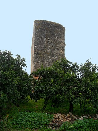
Dikilitaş is a neighbourhood in the municipality and district of Akdeniz, Mersin Province, Turkey. Its population is 1,069 (2022). It takes its name from an ancient Assyrian monument.
Ekşiler is a neighbourhood in the municipality and district of Silifke, Mersin Province, Turkey. Its population is 113 (2022). It is situated in the Göksu River valley. The village is to the north of Göksu River and Turkish state highway D.715. Its distance to Silifke is 10 kilometres (6.2 mi) and to Mersin is 95 kilometres (59 mi). The main economic activities of the village are farming and animal breeding.
Gündüzler is a neighbourhood in the municipality and district of Silifke, Mersin Province, Turkey. Its population is 222 (2022). The village is situated on the Taurus Mountains. Its distance to Silifke is 32 kilometres (20 mi) and to Mersin is 117 kilometres (73 mi).
Kepez is a neighbourhood in the municipality and district of Silifke, Mersin Province, Turkey. Its population is 93 (2022). It is situated in Taurus Mountains. It is 35 kilometres (22 mi) from the central town of Silifke and 120 kilometres (75 mi) from Mersin. The main economic activities are farming and animal husbandry.
Keşlitürkmenli is a neighbourhood in the municipality and district of Silifke, Mersin Province, Turkey. Its population is 327 (2022). It is situated in the Taurus Mountains. Distance to Silifke is 20 kilometres (12 mi) and to Mersin is 85 kilometres (53 mi). The important archaeological site Neopolis is about 8 kilometres (5.0 mi) north of the village. Main economic activity is farming.
Kırtıl is a neighbourhood in the municipality and district of Silifke, Mersin Province, Turkey. Its population is 56 (2022). It is situated on the southern slopes of the Taurus Mountains. Distance to Silifke is 15 kilometres (9.3 mi) and to Mersin is 110 kilometres (68 mi). Main economic activity of the village is farming.
