
Kangchenjunga, also spelled Kanchenjunga, Kanchanjanghā and Khangchendzonga, is the third-highest mountain in the world. Its summit lies at 8,586 m (28,169 ft) in a section of the Himalayas, the Kangchenjunga Himal, which is bounded in the west by the Tamur River, in the north by the Lhonak River and Jongsang La, and in the east by the Teesta River. It lies in the border region between Nepal and Sikkim state of India, with three of the five peaks, namely Main, Central and South, directly on the border, and the peaks West and Kangbachen in Nepal's Taplejung District.

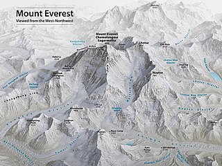
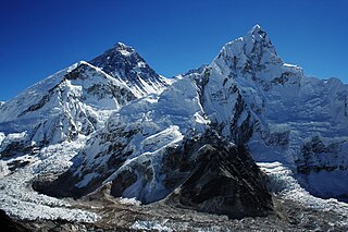
Mount Everest is Earth's highest mountain above sea level, located in the Mahalangur Himal sub-range of the Himalayas. The China–Nepal border runs across its summit point. Its elevation of 8,848.86 m was most recently established in 2020 by the Chinese and Nepali authorities.

Lhotse is the fourth highest mountain in the world at 8,516 metres (27,940 ft), after Mount Everest, K2, and Kangchenjunga. The main summit is on the border between Tibet Autonomous Region of China and the Khumbu region of Nepal.

Makalu is the fifth highest mountain in the world at 8,485 metres (27,838 ft). It is located in the Mahalangur Himalayas 19 km (12 mi) southeast of Mount Everest, on the China–Nepal border. One of the eight-thousanders, Makalu is an isolated peak in the shape of a four-sided pyramid.

Cho Oyu is the sixth-highest mountain in the world at 8,188 metres (26,864 ft) above sea level. Cho Oyu means "Turquoise Goddess" in Tibetan. The mountain is the westernmost major peak of the Khumbu sub-section of the Mahalangur Himalaya 20 km west of Mount Everest. The mountain stands on the China Tibet–Nepal Province No. 1 border.

Dhaulagiri, located in Nepal, is the seventh highest mountain in the world at 8,167 metres (26,795 ft) above sea level, and the highest mountain within the borders of a single country. It was first climbed on 13 May 1960 by a Swiss-Austrian-Nepali expedition. Annapurna I is 34 km (21 mi) east of Dhaulagiri. The Kali Gandaki River flows between the two in the Kaligandaki Gorge, said to be the world's deepest. The town of Pokhara is south of the Annapurnas, an important regional center and the gateway for climbers and trekkers visiting both ranges as well as a tourist destination in its own right.

Manaslu is the eighth-highest mountain in the world at 8,163 metres (26,781 ft) above sea level. It is in the Mansiri Himal, part of the Nepalese Himalayas, in west-central Nepal. Manaslu means "mountain of the spirit" and the word is derived from the Sanskrit word manasa, meaning "intellect" or "soul". Manaslu was first climbed on May 9, 1956, by Toshio Imanishi and Gyalzen Norbu, members of a Japanese expedition. It is said that, given the many unsuccessful attempts by the British to climb Everest before Nepali Tenzing Norgay and New Zealander Edmund Hillary, "just as the British consider Everest their mountain, Manaslu has always been a Japanese mountain".

Pumori is a mountain on the Nepal-China border in the Mahalangur section of the Himalayas. Pumori lies just eight kilometres west of Mount Everest. Pumori, meaning "the Mountain Daughter" in Sherpa language, was named by George Mallory. "Pumo" means young girl or daughter and "Ri" means mountain in Sherpa language. Climbers sometimes refer to Pumori as "Everest's Daughter". Mallory also called it Clare Peak, after his daughter.

Dudh Koshi is a river in eastern Nepal. It is the highest river in terms of elevation.

Mera Peak is a mountain in the Mahalangur section, Barun sub-section of the Himalaya and administratively in Nepal's Sagarmatha Zone, Sankhuwasabha. At 6,476 metres (21,247 ft) it is classified as a trekking peak. It contains three main summits: Mera North, 6,476 metres (21,247 ft); Mera Central, 6,461 metres (21,198 ft); and Mera South, 6,065 metres (19,898 ft), as well as a smaller "trekking summit", visible as a distinct summit from the south but not marked on most maps of the region.
Barry Blanchard is one of North America's top alpine climbers, noted for pushing the standards of highly technical, high-risk alpine climbing in the Canadian Rockies and the Himalayas.
Mount Everest is the world's highest mountain, with a peak at 8,849 metres (29,031.7 ft) above sea level. It is situated in the Himalayan range of Solukhumbu district, Nepal.
Victor Saunders is a British climber and author. He trained as an architect at the Architectural Association School of Architecture in London. His first book, Elusive Summits, won the Boardman Tasker Prize for Mountain Literature in 1991. He became as a UIAGM/IFMGA ski and mountain guide in 1996 and joined the SNGM in 2003. Saunders first reached the summit of Mount Everest in May 2004, and went on to climb it several more times. In 2020 he became president of the Alpine Club.

The Imja Khola is a tributary of the Dudh Kosi river in eastern Nepal. It drains the slopes of Mount Everest. The Khumbu Glacier melts into the Lobujya (Lobuche) River, which flows southward as the Imja Khola to its confluence with the Dudh Kosi at Tengboche.

Janusz Majer is a Polish alpinist, himalayanist and traveler. He is co-founder and co-owner of ADD Company, the owner of Alpinus brand (1993–2001), co-founder of Mount Company, the owner of the HiMountain brand which produces outdoor clothing and equipment and co-owner of the large chain of HiMountain shops in Poland. Since 23 November 2013 he's been the head of the program "Polish Himalayas".
Precipitated by unexpected permission from Tibet, the 1935 British Mount Everest reconnaissance expedition was planned at short notice as a preliminary to an attempt on the summit of Mount Everest in 1936. After exceptionally rancorous arguments involving the Mount Everest Committee in London, Eric Shipton was appointed leader following his successful trekking style of expedition to the Nanda Devi region in India in 1934.
Asian Trekking is a Nepal-based adventure company, specializing in mountaineering expeditions and trekking in the Himalayas. Started in December 1981 by UIAA Honorary Member Ang Tshering Sherpa, it is Nepal's oldest mountaineering and trekking company still in operation. In 2008, Tshering's son Dawa Steven Sherpa, an environmentalist and mountaineer, took over the leadership of the company and continues to serve as the managing director to this day.
After World War II, with Tibet closing its borders and Nepal becoming considerably more open, Mount Everest reconnaissance from Nepal became possible for the first time culminating in the successful ascent of 1953. In 1950 there was a highly informal trek to what was to become Everest Base Camp and photographs were taken of a possible route ahead. Next year the 1951 British Mount Everest reconnaissance expedition reconnoitred various possible routes to Mount Everest from the south and the only one they considered feasible was the one via the Khumbu Icefall, Western Cwm and South Col. In 1952, while the Swiss were making an attempt on the summit that nearly succeeded; the 1952 British Cho Oyu expedition practised high-altitude Himalayan techniques on Cho Oyu, nearby to the west.
The 1951 British Mount Everest reconnaissance expedition ran between 27 August 1951 and 21 November 1951 with Eric Shipton as leader.


