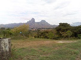
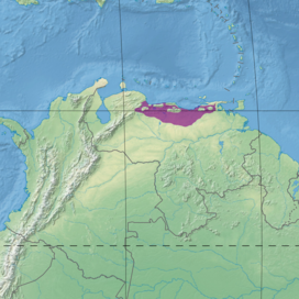
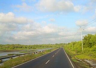
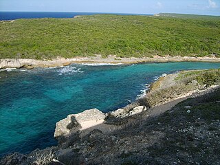
The La Costa xeric shrublands (NT1309) is an ecoregion in Venezuela that stretches along the Caribbean coast. The dry scrub and savanna has been subject to modification since the 16th century by European colonists who replaced it by a patchwork of farm fields and pasturage. Little of the original habitat remains.
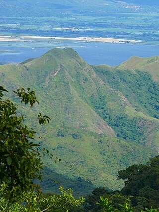
The La Costa xeric shrublands ecoregion extends along Venezuela's Caribbean coast, covering plains, hills and isolated mountains. Caracas, the capital of Venezuela, lies partly in this ecoregion.[1] It reaches from Sucre state in the east to Yaracuy state in the west.[2] The ecoregion includes areas of savanna, dry forest, moist forest, swamp and scrub. It has an area of 6,837,568 hectares (16,896,000 acres).[1]
The xeric shrublands are in the Coastal Cordillera geographical region. The shrublands, which blend into the Llanos grasslands to the south, surround the mountains of the Venezuelan Coastal Range. Elevations rise from sea level to 1,000 metres (3,300ft) in the upper foothills of the mountains. Along the coast there are sandy beaches, mangroves, lagoons and hilly patches of moist forest.[2]
Climate
Average annual temperature is around 20°C (68°F). Annual rainfall is 300–1,000 millimetres (12–39in).[2] At a sample location at coordinates 9°45′N66°15′W / 9.75°N 66.25°W / 9.75; -66.25 the Köppen climate classification is "Aw": equatorial, winter dry.[4] At this location the mean temperature varies from 24.5°C (76.1°F) in July to 26.5°C (79.7°F) in April. Total yearly rainfall is about 1,400 millimetres (55in). Monthly rainfall varies from 12.5 millimetres (0.49in) in March to 233.1 millimetres (9.18in) in July.[4]
The World Wildlife Fund gives the ecoregion the status of "Critical/Endangered". There is a large human population that dates back to 16th century colonists from Europe. Most of the natural habitat has been destroyed, particularly in the lower areas, replaced by a patchwork of towns, farm fields and pastures. A few areas of natural savanna and thorn forest remain. The El Ávila National Park and San Esteban National Park hold small areas of xeric shrubland.[2] Other protected areas include the Mochima National Park and the Henri Pittier National Park.[1]
The Global 200 is the list of ecoregions identified by the World Wide Fund for Nature (WWF), the global conservation organization, as priorities for conservation. According to WWF, an ecoregion is defined as a "relatively large unit of land or water containing a characteristic set of natural communities that share a large majority of their species dynamics, and environmental conditions". For example, based on their levels of endemism, Madagascar gets multiple listings, ancient Lake Baikal gets one, and the North American Great Lakes get none.
The ecology of California can be understood by dividing the state into a number of ecoregions, which contain distinct ecological communities of plants and animals in a contiguous region. The ecoregions of California can be grouped into four major groups: desert ecoregions, Mediterranean ecoregions, forested mountains, and coastal forests.
The Llanos is a vast tropical grassland plain situated to the east of the Andes in Colombia and Venezuela, in northwestern South America. It is an ecoregion of the tropical and subtropical grasslands, savannas, and shrublands biome.
The Venezuelan Coastal Range, also known as Venezuelan Caribbean Mountain System, is a mountain range system and one of the eight natural regions of Venezuela, that runs along the central and eastern portions of Venezuela's northern coast. The range is a northeastern extension of the Andes, and is also known as the Maritime Andes. It covers around 48,866 km2, being the 4th largest natural region in Venezuela.
The Cordillera de la Costa montane forests is a montane ecoregion of the tropical and subtropical moist broadleaf forests biome, in the Venezuelan Coastal Range on the Caribbean Sea in northern Venezuela.
The Guajira–Barranquilla xeric scrub is a xeric shrubland ecoregion in Colombia, Venezuela, and the ABC Islands, covering an estimated area of 150,000 km2 (58,000 sq mi). Rainfall varies from 125 to 600 mm, and the median temperature is 26 °C (79 °F).
The Motagua Valley thornscrub ecoregion is located in the Motagua valley in eastern Guatemala. Surrounded by mountains and receiving relatively little precipitation, the valley is one of the driest in Central America and is characterized by thorn scrub vegetation. It covers an area of 2330 km2 and belongs to the deserts and xeric shrublands biome, as defined by the World Wildlife Fund.
The Guianan savanna (NT0707) is an ecoregion in the south of Venezuela, Guyana and Suriname and the north of Brazil. It is in the Amazon biome. The savanna covers an area of rolling upland plains on the Guiana Shield between the Amazon and Orinoco basins. It includes forested areas, but these are shrinking steadily due to the effect of frequent fires, either accidental or deliberate. The ecoregion includes the Gran Sabana region of Venezuela.
The Amazon–Orinoco–Southern Caribbean mangroves (NT1401) is an ecoregion along the coasts of Colombia, Venezuela, Guyana, Suriname, French Guiana and Brazil.
The Espinal (NT0801) is an ecoregion of dry, thorny forest, savanna and steppe in Argentina. It has been extensively modified by large scale cattle ranching, but remnants of the original flora remain. It is threatened by the advance of the irrigation-based agricultural frontier.
The Marañón dry forests (NT0223) is an ecoregion in northern Peru. It covers the lower valley of the Marañón River and its tributaries along the eastern edge of the Andes. It has a dry climate due to rain shadow from mountains further east. The habitat has long been modified by farming, ranching and logging and is now threatened by construction of hydroelectric and irrigation dams.
The Apure–Villavicencio dry forests (NT0201) is an ecoregion in Venezuela and Colombia to the east of the eastern cordillera of the Andes. The ecoregion covers the transition zone between montane forests in the Andes and the llanos, or lowland grasslands. It has been severely degraded by deforestation, farming and ranching. The remnants are poorly protected.
The Cordillera Oriental montane forests (NT0118) is an ecoregion in Venezuela and Colombia along the east slopes of the eastern cordillera of the Andes. The extensive region of submontane and montane forests includes distinctive flora and fauna in the north, center and southern sections. The ecoregion is home to numerous endemic species of fauna. Despite extensive changes due to logging, farming and ranching, large areas of the original habitat remain intact, and the ecoregion has rich biodiversity.
The Maracaibo dry forests (NT0222) is an ecoregion in Venezuela around Lake Maracaibo. It contains the country's main oil fields. The habitat is criss-crossed by roads and is severely degraded by farming and livestock grazing.
The Paraguana xeric scrub (NT1313) is an ecoregion in Venezuela to the north and east of Lake Maracaibo and along the coast of Aruba, Bonaire, and Curaçao. The region holds flora and fauna adapted to the very dry conditions of the coastal dunes and inland areas of bush, scrub, briars and cacti. There are several endangered species of animals and birds. Efforts at protecting the environment have been ineffective. Most of the original trees have been cut down, dunes are being destabilized by loss of vegetation, scrub is replaced by farmland and vegetation is destroyed by grazing goats.
The Lara–Falcón dry forests (NT0219) is an ecoregion that extends inland from the Caribbean coast of northwestern Venezuela. To the east and west the dry forests of the hilly region transition into xeric shrublands. There are several endemic bird species including the vulnerable yellow-shouldered amazon, in demand as a pet. There are few protected areas. Despite the relatively infertile soils, a large part of the ecoregion has been converted to farmland or pasturage.
The Araya and Paria xeric scrub (NT1301) is an ecoregion in Venezuela that stretches along the Caribbean coast to the west of Trinidad, and that includes Margarita Island and some smaller islands. The ecoregion includes dune herbs, dry thorn scrubs and deciduous forests. The mountains on Margarita Island hold montane forests similar to those in the mainland coastal range. The beaches are used for breeding by sea turtles. Some endemic bird species are threatened with extinction by illegal capture for the pet trade. Deforestation and over-grazing by goats are also problems.
The Sinú Valley dry forests (NT0229) is an ecoregion in the north of Colombia.
The Leeward Islands xeric scrub ecoregion covers the dry ('xeric'), non-forested areas of the Leeward Islands on the northeastern edge of the Caribbean Sea, stretching from the Virgin Islands in the west to Guadeloupe to the southeast. The non-forested areas are generally low scrub shrub, on the low elevations around the peripheries of the islands. Non-forested lower elevations in the region receive less rainfall and are typically semi-arid. A notable feature of the ecoregion is its position in the main hurricane track. The frequent damage to trees allows more pre-climax shrubs and trees to grow. There are a number of endemic species, as in common with islands.
This page is based on this Wikipedia article Text is available under the CC BY-SA 4.0 license; additional terms may apply. Images, videos and audio are available under their respective licenses.