Transport in Venezuela revolves around a system of highways and airports. Venezuela is connected to the world primarily via air and sea. In the south and east the Amazon rainforest region has limited cross-border transport; in the west, there is a mountainous border of over 1,375 miles (2,213 km) shared with Colombia. The Orinoco River is navigable by oceangoing vessels up to 400 km inland, and connects the major industrial city of Ciudad Guayana to the Atlantic Ocean.

Aragua State is one of the 23 states of Venezuela. It is located in the north-central region of Venezuela. It has plains and jungles and Caribbean beaches. The most popular are Cata and Choroni. It has Venezuela's first national park which is called Henri Pittier. The capital is Maracay, other important cities include Turmero and El Limón.

Valencia is the capital city of Carabobo State and the third-largest city in Venezuela.

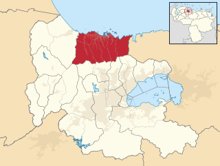
Carabobo State is one of the 23 states of Venezuela, located in the north of the country, about two hours by car from Caracas. The state capital city is Valencia, which is also the country's main industrial center. The state's area is 4,369 km2 (1,687 sq mi) and as of the 2011 census, had a population of 2,245,744.

Concordia, officially San Antonio de Padua de la Concordia, is the head town of the Concordia department, Entre Ríos Province, located in the Argentine Mesopotamia. It has 179,203 inhabitants according to the 2022 census [INDEC], making it the second largest in its province, and the 24th largest in Argentina.

Puerto Cabello is a city on the north coast of Venezuela. It is located in Carabobo State, about 210 km west of Caracas. As of 2011, the city had a population of around 182,400. The city is home to the largest and busiest port in the country and is thus a vital cog in the country's vast oil industry. The word 'cabello' translates to 'hair'. The Spanish took to saying that the sea was so calm there that a ship could be moored to the dock with a single hair.
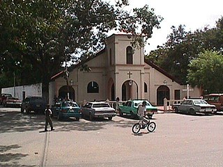
Borburata is a small coastal town in Carabobo state, Venezuela, located on the Caribbean Sea. It was long a destination of indigenous peoples, who would gather salt at the sea. It was colonized by the Spanish in the 16th century, but suffered so many raids that it was mostly abandoned. Residents moved inland. Today it has facilities associated with the Venezuela oil and gas industry.

The State Railways Institution is a state-run organization of Venezuela that manages the railway systems of the country. Its headquarters are located in Caracas, Venezuela.

The Naguanagua municipality is one of the 14 municipalities (municipios) that makes up the Venezuelan state of Carabobo and, according to the 2011 census by the National Institute of Statistics of Venezuela, the municipality has a population of 157,437. The town of Naguanagua is the shire town of the Naguanagua Municipality. It forms part of the greater Valencia Metropolitan Area in Venezuela. It is in the valley of the Cabriales River at the base of Cerro El Café and the El Trigal Mountain. Valencia and Naguanagua form a continuous urban area. The highway that runs from the centre of Valencia towards Puerto Cabello passes through this community; Bolivar Avenue in Valencia becomes University Avenue in Naguanagua on the northern side of a traffic roundabout, or redoma.
The Puerto Cabello Municipality is one of the 14 municipalities (municipios) that makes up the Venezuelan state of Carabobo. According to the 2011 census by the National Institute of Statistics of Venezuela, the municipality has a population of 182,493. The city of Puerto Cabello is the shire town of the Puerto Cabello Municipality.
Yagua is a Venezuelan town located to the Northwest of the Valencia Lake, in the Guacara Municipality in the Carabobo State. The area corresponds to the rural parish of the same name.

Fortín Solano is an eighteenth-century colonial fortification overlooking Puerto Cabello, Venezuela. With the Castillo San Felipe, an earlier fort built at sea level, it formed part of a complex of fortifications designed to protect Puerto Cabello and its important harbour from naval attacks. It was constructed c. 1766 by order of Don José Solano y Bote on behalf of the King of Spain. It has been described as the last military construction built in Venezuela during the colonial era.
Pedro Carujo (1801–1836) was a Venezuelan military officer. He was one of the leaders in the Revolution of the Reforms of 1835.

Génesis Cristina Carmona Tovar was a Venezuelan fashion model, beauty queen, and college student who was killed while protesting against the government of Venezuela during the 2014 Venezuelan protests. She later became a symbol of protest against the Nicolás Maduro government during the time of demonstrations in the country.
The First Battle of Carabobo (1814) was a battle in the Venezuelan War of Independence, in which the forces of the Second Republic, commanded by Simón Bolívar, defeated the Spanish forces under Field marshal Juan Manuel de Cajigal y Martínez.

San Felipe Castle is an eighteenth-century star fort protecting Puerto Cabello in Venezuela. It was named in honour of Philip V, King of Spain at the time of its construction in the 1730s. It has an alternative name Castillo Libertador, explained by its connection with Simón Bolívar, known as El Libertador because of his role in Latin American independence.
The 2018 Primera División season, officially Liga de Fútbol Profesional Venezolano or Liga FUTVE, was the 37th professional season of Venezuela's top-flight football league. Monagas were the defending champions, but did not qualify to the Serie Final, after being eliminated in the regular season of the Torneo Apertura and by Caracas in the quarter-finals of the Torneo Clausura.

The Plaza Bolívar is a square in Valencia, Venezuela. It occupies a central site, and is used for public meetings. Its origin was in the colonial period, when the city was laid out on a grid plan.(see note1) Some buildings in the vicinity, such as the Cathedral date from the colonial period.

The Camoruco railway terminus in Valencia, Venezuela, is a rare survival of a 19th-century railway station in the South America country. The building is also known as the Rectorado of the University of Carabobo. When the Puerto Cabello and Valencia railway closed in the 1950s, the station was transferred to the University of Carabobo which converted it for administrative use.