Dinira National Park

Last updated
Dinira National Park
Parque Nacional Dinira
Cascada del Vino Barbacoa Lara.JPG
Venezuela relief location map (+claimed).jpg
Red pog.svg
Location
LocationFlag of Venezuela.svg  Venezuela
Coordinates 9°25′N70°10′W / 9.417°N 70.167°W / 9.417; -70.167 Coordinates: 9°25′N70°10′W / 9.417°N 70.167°W / 9.417; -70.167
Area453.28 km2 (175.01 sq mi)
EstablishedNovember 30, 1988 (1988-11-30)

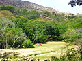
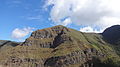
The Dinira National Park [1] [2] (Spanish : Parque nacional Dinira) [3] is a protected area with the national park status located between the states Lara, Portuguesa and Trujillo in the South American country of Venezuela. [4] It was created on November 30, 1988.

Contents

It was created in order to protect the upper basin of the Tocuyo River. In total there are five basins, Orinoco, Guanare, Motatán, and Lake Maracaibo, including the Tocuyo River.

It has an area of 45,328 hectares of mountainous relief in whose entrails are born in addition to the river Tocuyo, numerous streams of water of regional importance. This motivated the natives who populated it to call it Dinira, because its waters feed other currents below. It can rain up to 1,300 mm annually.

See also

Related Research Articles

Lara (state) State of Venezuela

Lara State is one of the 23 states (estados) into which Venezuela is divided. The state capital is Barquisimeto.

Desierto de los LeonesNational Park is located entirely within the limits of the Federal District; it stretches between Cuajimalpa and Álvaro Obregón boroughs. It is located in the Sierra de las Cruces mountain range west of the city center with an area of 1,867 hectares, representing fifteen percent of the entire Valley of Mexico. The term Desierto (‘desert’) is used in this context in the archaic sense of “wild, sparsely populated area” rather than in reference to an arid environment. Leones (‘Lions’) refers not to the big cats but rather to the original landlord's surname.

Iztaccíhuatl–Popocatépetl National Park

Iztaccíhuatl–Popocatépetl National Park, also known as Izta-Popo Zoquiapan National Park, is a national park in Mexico on the border of the states of México, Puebla, and Morelos. The park protects 39,819.08 hectares, surrounding Mexico's second- and third-highest peaks, the Popocatépetl and Iztaccíhuatl volcanoes as well as the area of the Hacienda de Zoquiapán, and its annexed areas (anexas) of Zoquiapan, Ixtlahuacán, and the Frío de Juárez River.

The Tamá National Natural Park is a national park located in the Tamá Massif of the Andean Region of Colombia, between the municipalities Toledo and Herrán, in the department of Norte de Santander, in the northeastern part of the Eastern Ranges of the Colombian Andes. One of the main attractions of the park is a 820-metre-high (2,690 ft) waterfall, one of the world's highest.

Tapo-Caparo National Park

The Tapo-Caparo National Park Also National Park Tapo Caparo Is a protected area with the national park status in Venezuela, which covers an area estimated at 2,050 square kilometers and is administratively located between the states of Barinas, Mérida and Táchira, to the west of Venezuelan territory. National park was decreed The 14 of January 1992 in the government of the then president Carlos Andrés Pérez.

El Guache National Park National park in Venezuela

The El Guache National Park Is a protected area with the status of national park in Venezuela, located at the beginning of the Andes mountain range, comprising mountainous parts of the Lara and Portuguesa states, and the birth of the Guache, Ospino, Toco, Morador and Are rivers. 2 In its adjacencies is the mighty waterfall San Miguel. It has an area of 12,200 ha traditionally measured and 15,960 Ha. Its temperature is between 19 °C. and 26 °C. Precipitation varies between 1800 and 2000 mm annually.

Tirgua National Park

Tirgua National Park, also known as General Manuel Manrique National Park, is a national park in Venezuela. It protects the headwaters of several waterways, especially the river Tirgua, which gives its name to the park.

Ciénagas del Catatumbo National Park

The Ciénagas del Catatumbo National Park Also Catatumbo Marshes National Park or Ciénagas de Juan Manuel National Park Is a protected area of Venezuela.

Mariusa National Park Venezuelan national park

The Mariusa National Park is a protected area of Venezuela with national park status.

Turuépano National Park

The Turuépano National Park Is a protected area with national park status in the South American country of Venezuela, located in the Benítez, Cajigal, Libertador and Mariño municipalities in the eastern part of Sucre State, north of the San Juan River and in front of the Gulf of Paria.

Sierra La Culata National Park

The Sierra La Culata National Park Also Sierra de la Culata National Park is a national park of Venezuela that is located in the northeastern branch of the Venezuelan Andes, in the states Mérida and Trujillo. It was decreed a national park on December 7, 1989. It has a high mountain climate, with temperatures ranging between −2 and 24 °C, and its surface area is 200,400 hectares (774 sq mi).

El Tamá National Park

The El Tamá National Park It is a protected area with the status of a national park that is located between the Andes and plains of Venezuela. It protects part of the Tamá Massif. It has an area of 139,000 hectares and is located in the states of Táchira and Apure, near the border with Colombia. Created as a National Park on December 12, 1978, by the then President Carlos Andrés Pérez.

Terepaima National Park

The Terepaima National Park Is a protected area with the status of national park in the South American country of Venezuela located in the mountainous region of the Lara and Portuguesa States. Specifically southeast of the city of Barquisimeto, capital of the Lara State, it covers areas belonging to the municipalities Iribarren, Palavecino and Simón Planas.

Aguaro-Guariquito National Park

The Aguaro-Guariquito National Park, also rendered as Aguaro Guariquito National Park, is a protected area with the status of national park in the South American country of Venezuela. Located in the region of the Llanos, it extends over the municipalities of Francisco de Miranda and Jose Rondon in Guárico state.

Laguna de Tacarigua National Park National park in Venezuela

The Laguna de Tacarigua National Park Also Tacarigua Lagoon National Park Is a protected area with the status of a national park located east of Miranda State, in the South American country of Venezuela. It comprises a permanent coastal lagoon of 7800 ha and 1.2 m of average depth, separated from the sea by a restinga or coastal barrier of 28.8 km long and 300–1000 m wide that was formed by the action of the sea current Which runs along the coast in an East-West direction.

Macarao National Park

The Macarao National Park Is a protected area with the status of a national park located in the Macarao, San Pedro and Jarillo rivers, in the north of the South American country of Venezuela. Its extension of 15,000 hectares covers part of the Capital District and Miranda State. The area was declared National Park in 1973.

Yacambú National Park

The Yacambú National Park is a protected area with national park status in the South American country of Venezuela. It is located in the south of the Lara State, on the southern slope of the Portuguesa Mountain Range, which forms part of the mountain foothills of the Andes Mountains. It was created in 1962 with the purpose of protecting part of the Yacambú river basin, whose waters will feed the reservoir José María Ochoa Pilé, an ambitious project still under construction. The reservoir is of vital importance for water supply in the city of Barquisimeto and for economic development in the dry valleys of Quibor, where there is a protected area of sustainable use for agricultural purposes.

Yurubí National Park National park in the north of Venezuela

The Yurubí National Park is a protected area with the status of national park in the north of the South American country of Venezuela. It was founded on March 18, 1960 in Yaracuy State created to protect the Yurubí river basin, which is the source of fresh water for the city of San Felipe. The Yurubí National Park is located in the mountains of the Sierra de Aroa. The park includes cloud forests and low montane forests and is surrounded by cultivated areas. The park is crossed by small trails, which are used mainly by poachers or by a small number of visitors and researchers. The park is not inhabited; The former settlers of the area were relocated many years ago.

Laguna de Las Marites Natural Monument

The Laguna de las Marites Natural Monument Also Las Marites Lagoon Natural Monument Is a protected area with natural monument status located on the southeast coast of the coastal plain of Margarita Island in Nueva Esparta state in the northwest of the South American country of Venezuela. It was declared a monument on February 27, 1974. It has an extension of 3674 ha, an altitude of 40 msnm and an average temperature of 26 ° C, with hypersaline waters.

Caura National Park

The Caura National Park is a protected area with the status of National Park in Venezuela. With an area of 7,534,000 ha. (75,340 km2) it is the largest park in the country and the most recently created (2017).

References

  1. Parque Nacional Dinira - ParksWatch
  2. Cunill, Pedro (1990-01-01). Venezuela: opciones geográficas (in Spanish). Fundación Eugenio Mendoza. ISBN   9789806017481.
  3. Boyla, Kerem; Estrada, Angélica; International, BirdLife (2017-03-15). Áreas importantes para la conservación de las aves en los Andes tropicales: sitios prioritarios para la conservación de la biodiversidad (in Spanish). BirdLife International. ISBN   9789978441961.
  4. Venezuela tierra mágica: Dinira: parque nacional, Estado Trujillo (in Spanish). Corpoven. 1999-01-01.