
Mont Blanc is the highest mountain in the Alps and Western Europe, rising 4,807.81 m (15,774 ft) above sea level. It is the second-most prominent mountain in Europe, after Mount Elbrus, and it is the eleventh most prominent mountain summit in the world. The mountain stands between the regions of Aosta Valley, Italy, and Savoie and Haute-Savoie, France. It gives its name to the Mont Blanc massif, bordering Switzerland and forming part of a larger range referred to as the Graian Alps. The location of the summit of Mont Blanc is on the watershed line between the valleys of Ferret and Veny in Italy and the valleys of Montjoie, and Arve in France, on the border between the two countries. Ownership of the summit area has long been a subject of historical dispute between the two countries.
A crevasse is a deep crack, crevice or fissure found in an ice sheet or glacier, or earth. Crevasses form as a result of the movement and resulting stress associated with the shear stress generated when two semi-rigid pieces above a plastic substrate have different rates of movement. The resulting intensity of the shear stress causes a breakage along the faces.

The Diablerets are a huge ice-covered mountain massif of the Alps, culminating at the Sommet des Diablerets at 3,210 metres (10,530 ft) above sea level and straddling the border between the Swiss cantons of Vaud (VD) and Valais (VS). The northeastern part of the massif stretches also into the canton of Bern (BE).

The Aiguille de Bionnassay is a mountain in the Mont Blanc massif of the Alps in France and Italy. It has been described as "one of the most attractive satellite peaks of Mont Blanc", and is located on its western side. The mountain's south and east ridges form the frontier between the two countries, and its summit is a knife-edge crest of snow and ice. Reaching it via any route provides a "splendid and serious snow and ice climb".

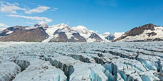
An icefall is a portion of certain glaciers characterized by relatively rapid flow and chaotic crevassed surface, caused in part by gravity. The term icefall is formed by analogy with the word waterfall, which is a similar phenomenon of the liquid phase but at a more spectacular speed. When ice movement of a glacier is faster than elsewhere, because the glacier bed steepens or narrows, and the flow cannot be accommodated by plastic deformation, the ice fractures, forming crevasses. Where two fractures meet, seracs can be formed. When the movement of the ice slows down, the crevasses can coalesce, resulting in the surface of the glacier becoming smoother.

The Khumbu Icefall is located at the head of the Khumbu Glacier and the foot of the Western Cwm, which lies at an altitude of 5,486 metres (17,999 ft) on the Nepali slopes of Mount Everest, not far above Base Camp and southwest of the summit. The icefall is considered one of the most dangerous stages of the South Col route to Everest's summit.

A bergschrund or rimaye is a crevasse that forms where moving glacier ice separates from the stagnant ice or firn above. It is often a serious obstacle for mountaineers, who sometimes abbreviate "bergschrund" to "schrund".
Crevasse Valley Glacier is a broad glacier about 30 miles (50 km) long, flowing west-southwest between the Chester Mountains and the Saunders Mountain to the Sulzberger Ice Shelf in Marie Byrd Land, Antarctica. It was discovered by a sledging party of the Byrd Antarctic Expedition, which visited this area in November–December 1934, and so named because of its extensively crevassed surface.

The Weissmies 4,017 m (13,179 ft) is a mountain in the Pennine Alps in the canton of Valais in Switzerland near the village of Saas-Fee. It is the easternmost four-thousander of its range.

The Allalinhorn is a mountain in the Pennine Alps in Switzerland. It lies between Zermatt and Saas-Fee in the canton of Valais, and is part of the Mischabel range, which culminates at the Dom.

Jiehkkevárri is a mountain on the border of the municipalities of Lyngen and Tromsø in Troms og Finnmark county, Norway. It is the highest mountain in Troms og Finnmark and has the second highest prominence among Norwegian mountains. The 1,834-metre (6,017 ft) tall mountain sits about 10 kilometres (6.2 mi) northeast of the village of Lakselvbukt and about 17 kilometres (11 mi) southwest of the village of Lyngseidet.
The Rosablanche is a mountain of the Swiss Pennine Alps, overlooking the Lac des Dix in the canton of Valais. It lies on the range between the valleys of Bagnes (west) and Hérémence (east), north of Le Pleureur.
The Mühlig-Hofmann Mountains is a major group of associated mountain features extending east to west for 100 km (62 mi) between the Gjelsvik Mountains and the Orvin Mountains in Queen Maud Land, East Antarctica. With its summit at 3,148 metres (10,328 ft), the massive Jøkulkyrkja Mountain forms the highest point in the Mühlig-Hofmann Mountains.
The Jutulpløgsla Crevasses form a crevasse field halfway up Jutulstraumen Glacier, about 8 nautical miles (15 km) southeast of Nashornet Mountain, in Queen Maud Land, Antarctica. They were mapped by Norwegian cartographers from surveys and air photos by the Norwegian–British–Swedish Antarctic Expedition (1949–52) and from air photos by the Norwegian expedition (1958–59) and named Jutulpløgsla.
Styggebrekka Crevasses is a crevasse field near the center of Austreskorve Glacier, in the Muhlig-Hofmann Mountains of Queen Maud Land. Plotted from surveys and air photos by Norwegian Antarctic Expedition (1956–60) and named Styggebrekka.
The Hamarglovene Crevasses are a crevasse field in lower Vestreskorve Glacier just east of Hamaroya Mountain, in the Mühlig-Hofmann Mountains of Queen Maud Land, Antarctica. They were mapped from surveys and air photos by the Sixth Norwegian Antarctic Expedition (1956–60) and named Hamarglovene.
Crevasse Crag is a jagged steep-sided prominence on the summit of a glaciated mountain ridge in the Lillooet Ranges of southwestern British Columbia, Canada. It is located about 49 km (30 mi) southeast of the village of Pemberton. Situated on the boundary between New Westminster Land District and Kamloops Division Yale Land District, the peak has a maximum elevation of 2,496 m (8,189 ft) and a topographic prominence of 66 m (217 ft).
Auden's Col is a high altitude mountain pass connecting Rudugaira valley and Bhilangna valley in India. It is situated at 5,490 metres (18,010 ft) elevation and connects the ridge coming from Gangotri III peak on the north-west and the ridge coming from Jogin I on the east, and also binds a glacier coming from Jogin I on the north side of Rudugaira valley, and deadly Khatling glacier on the south side of Bhilangna valley.
The Tour Ronde is a mountain in the Mont Blanc massif of the Alps, situated on the border between France and Italy. It is a prominent mountain, some 3.5 km north-east of Mont Blanc, but is effectively part of a continuation of the south eastern spur of Mont Maudit which forms a frontier ridge between the two countries. It is easily accessible to mountaineers and provides not only a very good viewpoint from its summit of the Brenva face and the major peaks on the southern side of Mont Blanc, but it also offers a popular introduction to alpine climbing of all grades, including a north face ascent.

Élisabeth Revol is a French high-altitude climber. In January 2018 Revol became the first woman to have climbed Nanga Parbat in Pakistan in winter; on the descent she was heroically rescued, while her teammate Tomasz Mackiewicz died, an event which was widely covered by the mainstream press. Having narrowly avoided amputation of her left foot she traversed consecutively Mount Everest and Lhotse in May 2019.

