La Foa

Last updated
La Foa
Locator map of La Foa 2018.png
Location of the commune (in red) within New Caledonia
Location of La Foa
La Foa
Coordinates: 21°42′41″S165°49′06″E / 21.7115°S 165.8182°E / -21.7115; 165.8182 Coordinates: 21°42′41″S165°49′06″E / 21.7115°S 165.8182°E / -21.7115; 165.8182
Country France
Sui generis collectivity New Caledonia
Province South Province
Government
  Mayor (20222026) Florence Rolland [1]
Area
1
464.0 km2 (179.2 sq mi)
Population
 (2019 census) [2]
3,552
  Density7.7/km2 (20/sq mi)
Ethnic distribution
  2019 census Kanaks 31.11%
Europeans 28.66%
Wallisians and Futunans 10.67%
Mixed 17.96%
Other 11.6%
Time zone UTC+11:00
INSEE/Postal code
98813 /98880
Elevation0–1,058 m (0–3,471 ft)
(avg. 20 m or 66 ft)
1 New Caledonia Land Register (DITTT) data, which exclude lakes and ponds larger than 1 km² (0.386 sq mi or 247 acres) as well as the estuaries of rivers.
O'kono ceremonial ax - La Foa MHNT O'kono hache ceremonielle Nouvelle Caledonie MHNT.jpg
O'kono ceremonial ax - La Foa MHNT

La Foa is a commune in the South Province of New Caledonia, an overseas territory of France in the Pacific Ocean.

Contents

Although the provincial seat of the South Province is in Nouméa, La Foa was made the chief town of the administrative subdivision of the South in order to counterbalance the overwhelming weight of Nouméa in New Caledonia. Both entities share an almost identical territory, but their status and role is quite different: the South Province, with its provincial assembly in Nouméa, is a full political division, whereas the administrative subdivision of the South is only an administrative division of the French central state, akin to an arrondissement of Metropolitan France, with a Deputy Commissioner of the Republic (commissaire délégué de la République), akin to a subprefect of metropolitan France, in residence in La Foa.

Geography

Climate

La Foa has a tropical monsoon climate (Köppen climate classification Am). The average annual temperature in La Foa is 22.7 °C (72.9 °F). The average annual rainfall is 1,128.4 mm (44.43 in) with February as the wettest month. The temperatures are highest on average in February, at around 26.5 °C (79.7 °F), and lowest in July, at around 18.9 °C (66.0 °F). The highest temperature ever recorded in La Foa was 38.0 °C (100.4 °F) on 12 December 1952; the coldest temperature ever recorded was 4.2 °C (39.6 °F) on 29 July 1968.

Climate data for La Foa (1991−2020 normals, extremes 1952−present)
MonthJanFebMarAprMayJunJulAugSepOctNovDecYear
Record high °C (°F)36.4
(97.5)
37.1
(98.8)
36.9
(98.4)
34.8
(94.6)
33.5
(92.3)
32.5
(90.5)
31.2
(88.2)
32.0
(89.6)
34.5
(94.1)
34.8
(94.6)
37.2
(99.0)
38.0
(100.4)
38.0
(100.4)
Average high °C (°F)31.7
(89.1)
31.8
(89.2)
30.9
(87.6)
29.5
(85.1)
27.5
(81.5)
26.0
(78.8)
25.1
(77.2)
25.3
(77.5)
26.9
(80.4)
28.8
(83.8)
30.1
(86.2)
31.3
(88.3)
28.7
(83.7)
Daily mean °C (°F)26.0
(78.8)
26.5
(79.7)
25.8
(78.4)
24.0
(75.2)
21.8
(71.2)
20.1
(68.2)
18.9
(66.0)
18.9
(66.0)
20.0
(68.0)
21.9
(71.4)
23.5
(74.3)
25.3
(77.5)
22.7
(72.9)
Average low °C (°F)20.4
(68.7)
21.3
(70.3)
20.7
(69.3)
18.5
(65.3)
16.0
(60.8)
14.2
(57.6)
12.6
(54.7)
12.5
(54.5)
13.1
(55.6)
15.0
(59.0)
16.9
(62.4)
19.2
(66.6)
16.7
(62.1)
Record low °C (°F)12.0
(53.6)
9.0
(48.2)
12.2
(54.0)
8.8
(47.8)
7.0
(44.6)
4.9
(40.8)
4.2
(39.6)
5.4
(41.7)
5.3
(41.5)
6.0
(42.8)
8.5
(47.3)
11.4
(52.5)
4.2
(39.6)
Average precipitation mm (inches)155.0
(6.10)
184.3
(7.26)
177.3
(6.98)
102.9
(4.05)
78.0
(3.07)
72.2
(2.84)
64.8
(2.55)
62.7
(2.47)
35.7
(1.41)
29.6
(1.17)
63.2
(2.49)
102.7
(4.04)
1,128.4
(44.43)
Average precipitation days (≥ 1.0 mm)9.911.411.77.87.47.06.56.24.03.95.78.189.5
Source: Météo-France [3]

Related Research Articles

<span class="mw-page-title-main">Nouméa</span> Capital of New Caledonia

Nouméa is the capital and largest city of the French special collectivity of New Caledonia and is also the largest francophone city of Oceania. It is situated on a peninsula in the south of New Caledonia's main island, Grande Terre, and is home to the majority of the island's European, Polynesian, Indonesian, and Vietnamese populations, as well as many Melanesians, Ni-Vanuatu and Kanaks who work in one of the South Pacific's most industrialised cities. The city lies on a protected deepwater harbour that serves as the chief port for New Caledonia.

<span class="mw-page-title-main">Ouvéa</span> Commune in New Caledonia, France

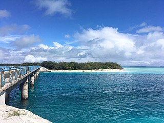
Ouvéa or Uvea is a commune in the Loyalty Islands Province of New Caledonia, an overseas territory of France in the Pacific Ocean. The settlement of Fayaoué [faˈjawe], on Ouvéa Island, is the administrative centre of the commune.

<span class="mw-page-title-main">Lifou</span> Commune in New Caledonia, France

Lifou[lifu] is a commune of France in the Loyalty Islands Province of New Caledonia in the Pacific Ocean.

<span class="mw-page-title-main">Le Mont-Dore (New Caledonia)</span> Commune in New Caledonia, France

Le Mont-Dore is a commune in the suburbs of Nouméa in the South Province of New Caledonia, an overseas territory of France in the Pacific Ocean.

<span class="mw-page-title-main">Punaauia</span> Commune in French Polynesia, France

Punaʻauia is a commune in the suburbs of Papeʻete in French Polynesia, an overseas territory of France in the Pacific Ocean. Punaʻauia is located on the island of Tahiti, in the administrative subdivision of the Windward Islands, themselves part of the Society Islands. In the late 1890s, the French painter Paul Gauguin lived in Punaʻauia. Here he painted his masterpiece Where Do We Come From? What Are We? Where Are We Going?. The commune borders Faʻaʻā on the north and Pāʻea on the south.

<span class="mw-page-title-main">South Province, New Caledonia</span> Place in New Caledonia, France

The South Province is one of three administrative subdivisions in New Caledonia. It corresponds to the southern and southwestern portion of the New Caledonian mainland.

The French sui generis collectivity of New Caledonia is divided into three provinces, which in turn are divided into 33 communes. There is also a system of eight tribal areas for the indigenous Kanak people, and three decentralized subdivisions.

<span class="mw-page-title-main">Bourail</span> Commune in New Caledonia, France

Bourail is a commune in the South Province of New Caledonia, an overseas territory of France in the Pacific Ocean.

<span class="mw-page-title-main">Houaïlou</span> Commune in New Caledonia, France

Houaïlou is a commune in the North Province of New Caledonia, an overseas territory of France in the Pacific Ocean.

<span class="mw-page-title-main">Koné, New Caledonia</span> Commune in New Caledonia, France

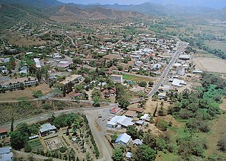
Koné is a commune in the North Province of New Caledonia, a special collectivity of France in the Pacific Ocean. Koné is the provincial seat of the North Province.

<span class="mw-page-title-main">Païta</span> Commune in New Caledonia, France

Païta is a commune in the suburbs of Nouméa in the South Province of New Caledonia, an overseas territory of France in the Pacific Ocean. New Caledonia's international airport, La Tontouta International Airport, is located there.

<span class="mw-page-title-main">Pouébo</span> Commune in New Caledonia, France

Pouébo is a commune in the North Province of New Caledonia, an overseas territory of France in the Pacific Ocean.

<span class="mw-page-title-main">Pouembout</span> Commune in New Caledonia, France

Pouembout is a commune in the North Province of New Caledonia, an overseas territory of France in the Pacific Ocean.

<span class="mw-page-title-main">Poya, New Caledonia</span> Commune in New Caledonia, France

Poya is a commune in New Caledonia, an overseas territory of France in the Pacific Ocean. The largest part of the commune lies in the North Province of New Caledonia, and a smaller part of the commune lies in the South Province, an odd situation resulting from the creation of New Caledonia's provinces in 1989. At the 2019 census, 2,592 of the 2,802 inhabitants of Poya lived on the North Province's side of the commune, while only 210 inhabitants lived on the South Province's side.
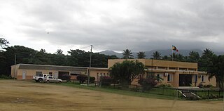
<span class="mw-page-title-main">Touho</span> Commune in New Caledonia, France

Touho is a municipality (commune) in the North Province of New Caledonia, an overseas territory of France in the Pacific Ocean. Touho lies on the east coast of the main island and is served by a road and an airfield.

<span class="mw-page-title-main">Yaté</span> Commune in New Caledonia, France

Yaté is a commune in the South Province of New Caledonia, an overseas territory of France in the Pacific Ocean. The Yaté Dam and Blue River Provincial Park are located within the commune.

<span class="mw-page-title-main">Boulouparis</span> Commune in New Caledonia, France

Boulouparis is a commune in the South Province of New Caledonia, an overseas territory of France in the Pacific Ocean.

LÎle-des-Pins Commune in New Caledonia, France

L'Île-des-Pins is a commune in the South Province of New Caledonia, an overseas territory of France in the Pacific Ocean. L'Île-des-Pins is made up of the Isle of Pines, the smaller Kôtomo Island, and several islets around these two, as well as the distant island of Walpole, which is located almost 150 kilometres to the east. The Isle of Pines and adjacent islands are located to the south of New Caledonia's mainland. At 16,830 km from Paris, L'Île-des-Pins is further from the French capital than any other commune of France. The settlement of Vao, on the Isle of Pines, is the administrative centre of the commune of L'Île-des-Pins.

<span class="mw-page-title-main">Maré Island</span> Commune in New Caledonia, France

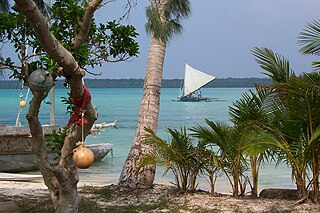
Maré Island or Nengone is the second-largest of the Loyalty Islands, in the archipelago of New Caledonia, an overseas territory of France in the Pacific Ocean. The island is part of the commune (municipality) of Maré, in the Loyalty Islands Province of New Caledonia.

<span class="mw-page-title-main">Loyalty Islands Province</span> Place in New Caledonia, France

The Loyalty Islands Province is one of three administrative subdivisions of New Caledonia encompassing the Loyalty Island archipelago in the Pacific, which are located northeast of the New Caledonian mainland of Grande Terre.

References

  1. "Répertoire national des élus: les maires" (in French). data.gouv.fr, Plateforme ouverte des données publiques françaises. 13 September 2022.
  2. Population, ménages et logement par commune, en 2019, Institut de la statistique et des études économiques Nouvelle-Calédonie
  3. "Fiche Climatologique Statistiques 1991-2020 et records" (PDF). Météo-France . Retrieved August 25, 2022.

Wikivoyage-Logo-v3-icon.svg La Foa travel guide from Wikivoyage