Lifou

Last updated
Lifou
Lifou falaises Xodre.JPG
The cliffs of Xodre in Lifou
Locator map of Lifou 2018.png
Location of the commune (in red) within New Caledonia
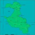
Location of Lifou
Lifou
Coordinates: 20°58′00″S167°14′00″E / 20.9667°S 167.2333°E / -20.9667; 167.2333
Country France
Sui generis collectivity New Caledonia
Province Loyalty Islands Province
(provincial seat)
Government
  Mayor (20202026) Robert Xowie [1]
Area
1
1,207.1 km2 (466.1 sq mi)
Population
 (2019 census) [2]
9,195
  Density7.6/km2 (20/sq mi)
Ethnic distribution
  2019 census Kanaks 94.39%
Europeans 2.66%
Wallisians and Futunans 0.09%
Mixed 1.73%
Other 1.13%
Time zone UTC+11:00
INSEE/Postal code
98814 /98820
Elevation0–104 m (0–341 ft)
(avg. 30 m or 98 ft)
1 New Caledonia Land Register (DITTT) data, which exclude lakes and ponds larger than 1 km² (0.386 sq mi or 247 acres) as well as the estuaries of rivers.

Lifou [lifu] is a commune of France in the Loyalty Islands Province of New Caledonia in the Pacific Ocean.

Contents

Geography

Lifou is made up of Lifou Island, the largest and most heavily populated of the Loyalty Islands, [3] its smaller neighbour Tiga Island, and several uninhabited islets in between these two. All these islands lie among the Loyalty Islands, 190 kilometres (105 nautical miles) northeast of New Caledonia's mainland. At 1,146 km2 (442 sq mi), Lifou Island is the largest atoll in the world. [4]

The town of , on Lifou Island, is the administrative centre of the commune of Lifou as well as the provincial seat of the Loyalty Islands Province. [3]

Climate

Lifou has a tropical rainforest climate (Köppen climate classification: Af) that closely borders a tropical monsoon climate (Köppen climate classification: Am). The average annual temperature in Lifou is 23.4 °C (74.1 °F). The average annual rainfall is 1,579.0 mm (62.17 in) with March as the wettest month. The temperatures are highest on average in February, at around 26.6 °C (79.9 °F), and lowest in August, at around 20.1 °C (68.2 °F). The highest temperature ever recorded in Lifou was 34.6 °C (94.3 °F) on 7 February 2016; the coldest temperature ever recorded was 4.4 °C (39.9 °F) on 27 July 1985.

Climate data for Lifou (Ouanaham, 1991−2020 normals, extremes 1960−present)
MonthJanFebMarAprMayJunJulAugSepOctNovDecYear
Record high °C (°F)33.3
(91.9)
34.6
(94.3)
32.1
(89.8)
31.9
(89.4)
30.3
(86.5)
29.5
(85.1)
30.0
(86.0)
28.9
(84.0)
30.6
(87.1)
30.3
(86.5)
32.2
(90.0)
32.8
(91.0)
34.6
(94.3)
Mean daily maximum °C (°F)29.6
(85.3)
30.0
(86.0)
29.3
(84.7)
28.1
(82.6)
26.3
(79.3)
25.0
(77.0)
24.3
(75.7)
24.4
(75.9)
25.4
(77.7)
26.6
(79.9)
27.7
(81.9)
28.9
(84.0)
27.1
(80.8)
Daily mean °C (°F)26.2
(79.2)
26.6
(79.9)
26.2
(79.2)
24.9
(76.8)
22.7
(72.9)
21.4
(70.5)
20.1
(68.2)
20.0
(68.0)
21.0
(69.8)
22.5
(72.5)
23.9
(75.0)
25.3
(77.5)
23.4
(74.1)
Mean daily minimum °C (°F)22.8
(73.0)
23.3
(73.9)
23.1
(73.6)
21.7
(71.1)
19.1
(66.4)
17.7
(63.9)
15.9
(60.6)
15.7
(60.3)
16.6
(61.9)
18.5
(65.3)
20.0
(68.0)
21.6
(70.9)
19.7
(67.5)
Record low °C (°F)11.0
(51.8)
14.1
(57.4)
13.6
(56.5)
10.9
(51.6)
7.4
(45.3)
5.5
(41.9)
4.4
(39.9)
4.5
(40.1)
5.5
(41.9)
7.0
(44.6)
8.5
(47.3)
10.0
(50.0)
4.4
(39.9)
Average precipitation mm (inches)174.2
(6.86)
194.9
(7.67)
242.4
(9.54)
185.2
(7.29)
144.8
(5.70)
127.8
(5.03)
88.2
(3.47)
70.8
(2.79)
70.4
(2.77)
66.6
(2.62)
75.9
(2.99)
137.8
(5.43)
1,579
(62.17)
Average precipitation days (≥ 1.0 mm)12.113.015.411.911.79.58.06.56.27.07.410.1118.8
Mean monthly sunshine hours 223.4186.8194.0194.6178.3151.4180.0194.5208.7236.1230.1233.82,411.5
Source 1: Météo-France [5]
Source 2: Service de la météorologie de la Nouvelle-Calédonie [6]

Geology

Like Maré and Ouvéa, the other Loyalty islands, Lifou is made of fossil coral. [7] Lifou is a makatea (raised coral atoll), an ancient lagoon slowly raised by geological processes. [8] Due to the uplift, Lifou consists of a wide, flat centre surrounded by cliffs which correspond to the ancient reefal cliffs. [9] The coral rock exhibits high porosity and hence, neither Lifou nor any of the other Loyalty Islands have surface water. [10] It does, however, have a large freshwater reservoir which can be accessed through caves. These caves were used in the past when searching for fresh water, and are very important to the island's mythology.

History

Economic

The first Europeans to have contact with Lifouans were whalers, who had very limited, and certainly not friendly, communications with them. [11] Sandalwood traders also came to New Caledonia around 1841. [12]

Religious

By the mid-19th century, there were Anglican missionaries at work on Lifou, although there had been natives and Polynesian immigrants doing religious work before then. [13] In 1843, French Catholic missionaries arrived on Lifou; [13] shortly afterward, the Anglicans and Catholics became involved in a religious war that lasted until the French takeover of Lifou in 1864. [14] The missionaries even established a school on Lifou Island, [13] and from 1840 to the early 20th century taught most of the population to read. [8] In 1866, St. Anne Chapel was built in Inagoj. In recent years Lifouans have been referred to as "devout Christians." [15]

Economy

Tourism

Lifou is a popular cruise port, [16] with many cruises coming from Australia. [17] The most common port-of-call is Easo; the ships anchor just off the island and tender passengers ashore, being too large for the wharf there. Lifou is known for its snorkeling. [18]

Farming

The Lifouans grow several crops, including yams, taro, and bananas; they also produce copra. [3]

Notable residents

Images of Lifou

Related Research Articles

<span class="mw-page-title-main">Geography of New Caledonia</span>

The geography of New Caledonia (Nouvelle-Calédonie), an overseas collectivity of France located in the subregion of Melanesia, makes the continental island group unique in the southwest Pacific. Among other things, the island chain has played a role in preserving unique biological lineages from the Mesozoic. It served as a waystation in the expansion of the predecessors of the Polynesians, the Lapita culture. Under the Free French it was a vital naval base for Allied Forces during the War in the Pacific.

<span class="mw-page-title-main">Gambier Islands</span> Archipelago in French Polynesia

The Gambier Islands are an archipelago in French Polynesia, located at the southeast terminus of the Tuamotu archipelago. They cover an area of 27.8 km2 or 10.7 sq mi, and are made up of the Mangareva Islands, a group of high islands remnants of a caldera along with islets on the surrounding fringing reef, and the uninhabited Temoe atoll, which is located 45 km south-east of the Mangareva Islands. The Gambiers are generally considered a separate island group from Tuamotu both because their culture and language (Mangarevan) are much more closely related to those of the Marquesas Islands, and because, while the Tuamotus comprise several chains of coral atolls, the Mangareva Islands are of volcanic origin with central high islands.

<span class="mw-page-title-main">Ouvéa</span> Commune in New Caledonia, France

Ouvéa or Uvea is a commune in the Loyalty Islands Province of New Caledonia, an overseas territory of France in the Pacific Ocean. The settlement of Fayaoué, on Ouvéa Island, is the administrative centre of the commune.

<span class="mw-page-title-main">Lifou Island</span> Pacific island of New Caledonia

Lifou Island, historically spelt Lifu or Lefu in English, and known as Drehu in the local language, is the largest, most populous and most important island of the Loyalty Islands, in the archipelago of New Caledonia, an overseas territory of France in the Pacific Ocean. With a total area of 1,207 km2 (466 sq mi), Lifou is located east of Australia at 20.9°S 167.2°E.

<span class="mw-page-title-main">Le Mont-Dore (New Caledonia)</span> Commune in New Caledonia, France

Le Mont-Dore is a commune in the suburbs of Nouméa in the South Province of New Caledonia, an overseas territory of France in the Pacific Ocean.

<span class="mw-page-title-main">Punaauia</span> Commune in French Polynesia, France

Puna'auia is a commune in the suburbs of Papeʻete in French Polynesia, an overseas territory of France in the Pacific Ocean. Puna'auia is located on the island of Tahiti, in the administrative subdivision of the Windward Islands, themselves part of the Society Islands. In the late 1890s, the French painter Paul Gauguin lived in Puna'auia. Here he painted his masterpiece Where Do We Come From? What Are We? Where Are We Going?. The commune borders Faʻaʻā on the north and Pāʻea on the south.

Drehu is an Austronesian language mostly spoken on Lifou Island, Loyalty Islands, New Caledonia. It has about 12,000 fluent speakers and the status of a French regional language. This status means that pupils can take it as an optional topic for the baccalauréat in New Caledonia itself or on the French mainland. It has been also taught at the Institut national des langues et civilisations orientales (INALCO) in Paris since 1973 and at the University of New Caledonia since 2000. Like other Kanak languages, Drehu is regulated by the Académie des langues kanak, founded in 2007.

<span class="mw-page-title-main">Bourail</span> Commune in New Caledonia, France

Bourail is a commune in the South Province of New Caledonia, an overseas territory of France in the Pacific Ocean.

<span class="mw-page-title-main">Houaïlou</span> Commune in New Caledonia, France

Houaïlou is a commune in the North Province of New Caledonia, an overseas territory of France in the Pacific Ocean.

<span class="mw-page-title-main">Koné, New Caledonia</span> Commune in New Caledonia, France

Koné is a commune in the North Province of New Caledonia, a special collectivity of France in the Pacific Ocean. Koné is the provincial seat of the North Province.

<span class="mw-page-title-main">La Foa</span> Commune in New Caledonia, France

La Foa is a commune in the South Province of New Caledonia, an overseas territory of France in the Pacific Ocean.

<span class="mw-page-title-main">Païta</span> Commune in New Caledonia, France

Païta is a commune in the suburbs of Nouméa in the South Province of New Caledonia, an overseas territory of France in the Pacific Ocean. New Caledonia's international airport, La Tontouta International Airport, is located there.

<span class="mw-page-title-main">Poya, New Caledonia</span> Commune in New Caledonia, France

Poya is a commune in New Caledonia, an overseas territory of France in the Pacific Ocean. The largest part of the commune lies in the North Province of New Caledonia, and a smaller part of the commune lies in the South Province, an odd situation resulting from the creation of New Caledonia's provinces in 1989. At the 2019 census, 2,592 of the 2,802 inhabitants of Poya lived on the North Province's side of the commune, while only 210 inhabitants lived on the South Province's side.

<span class="mw-page-title-main">Touho</span> Commune in New Caledonia, France

Touho is a municipality (commune) in the North Province of New Caledonia, an overseas territory of France in the Pacific Ocean. Touho lies on the east coast of the main island and is served by a road and an airfield.

<span class="mw-page-title-main">Yaté</span> Commune in New Caledonia, France

Yaté is a commune in the South Province of New Caledonia, an overseas territory of France in the Pacific Ocean. The Yaté Dam and Blue River Provincial Park are located within the commune.

<span class="mw-page-title-main">Boulouparis</span> Commune in New Caledonia, France

Boulouparis is a commune in the South Province of New Caledonia, an overseas territory of France in the Pacific Ocean.

<span class="mw-page-title-main">Maré Island</span> Commune in New Caledonia, France

Maré Island or Nengone is the second-largest of the Loyalty Islands, in the archipelago of New Caledonia, an overseas territory of France in the Pacific Ocean. The island is part of the commune (municipality) of Maré, in the Loyalty Islands Province of New Caledonia.

<span class="mw-page-title-main">Loyalty Islands Province</span> Place in New Caledonia, France

Loyalty Islands Province is one of the three top-level administrative subdivisions of New Caledonia. It encompasses the Loyalty Islands archipelago in the Pacific Ocean, located northeast of the New Caledonian mainland of Grande Terre.

<span class="mw-page-title-main">Takaroa</span> Atoll in French Polynesia

Takaroa, Taka-roa or Takapua, is an atoll in the Tuamotu group in French Polynesia. It has a length of 27.4 kilometres and a width of 7 km (4 mi); its land area is 20 square kilometres.

<span class="mw-page-title-main">Bora-Bora (commune)</span> Place in French Polynesia, France

Bora-Bora is a commune of French Polynesia, an overseas territory of France in the Pacific Ocean. The commune is in the administrative subdivision of the Leeward Islands. Its population was 10,549 at the 2017 census.

References

  1. "Répertoire national des élus: les maires" (in French). data.gouv.fr, Plateforme ouverte des données publiques françaises. 13 September 2022.
  2. Population, ménages et logement par commune, en 2019, Institut de la statistique et des études économiques Nouvelle-Calédonie
  3. 1 2 3 Murray, Lorraine (2009), "Lifou Island", Encyclopædia Britannica Online, Encyclopædia Britannica , retrieved 2009-07-16
  4. Calder, Joshua (2003-12-14), Island Misinformation , retrieved 2009-07-18
  5. "Fiche Climatologique Statistiques 1991-2020 et records" (PDF) (in French). Météo-France . Retrieved August 26, 2022.
  6. "Climate of Poindimié 1981-2010" (PDF) (in French). Météo-France . Retrieved April 8, 2022.
  7. Wallace, Alfred Russel; Keane, Augustus Henry (1888), Augustus Henry Keane (ed.), Australasia (5th ed.), E. Stanford
  8. 1 2 Lenwood, Frank (1917), Pastels from the Pacific, Oxford University Press
  9. Woodward, Henry (1899), Geological Magazine, Cambridge University Press
  10. Parrott-Sheffer, Chelsey (2009), "New Caledonia: French Overseas Country, Pacific Ocean", Encyclopædia Britannica Online, Encyclopædia Britannica , retrieved 2009-08-13
  11. McFarlane, Samuel (1873), The Story of the Lifu Mission, London: James Nisbet & Co.
  12. Keesing, Roger (1988), Melanesian Pidgin and the Oceanic Substrate, Stanford University Press, ISBN   0-8047-1450-9
  13. 1 2 3 Garrett, John (1982), To live among the stars: Christian origins in Oceania (2nd ed.), University of the South Pacific, ISBN   2-8254-0692-9
  14. Stanley, David (2004), South Pacific (8th ed.), Moon Handbooks, p. 1136, ISBN   1-56691-411-6
  15. Douglas, Bronwen (1998), Across the Great Divide: Journeys in History and Anthropology, Taylor & Francis, ISBN   90-5702-306-7
  16. Fleming, Donna (2008-09-10), Lifou: Dropping in on paradise, The New Zealand Herald , retrieved 2009-07-17
  17. McKinnon, Ian (2008-10-01), Lifou - a little island treasure, The Sydney Morning Herald , retrieved 2009-07-24
  18. Maley, Jacqueline (2008-10-01), Sail Away, Sail Away, The Sydney Morning Herald , retrieved 2009-08-07
  19. Maddaford, Terry (2008-12-04), Passion burns deeply for French star, The New Zealand Herald , retrieved 2009-07-24
  20. "Rosine Streeter". Pacific Community. 2017-07-27. Retrieved 2017-11-28.