The following is a list of the 698 communes of the Côte-d'Or department of France.

Biéville-Beuville is a commune in the Calvados department in the Normandy region in northwestern France. The hyphenated name originates from the former communes of Biéville-sur-Orne and Beuville, which were united in 1972.

The following is a list of the 464 communes of the Puy-de-Dôme department of France.

The following is a list of the 507 communes of the Seine-et-Marne department of France.

Vandœuvre-lès-Nancy is a commune in the Meurthe-et-Moselle department in north-eastern France. Its inhabitants are called Vandopériens.

Saint-Hilaire-des-Landes is a commune in the Ille-et-Vilaine department in Brittany in northwestern France.

Pontault-Combault is a commune in the Seine-et-Marne department in the Île-de-France region in north-central France. It is located in the eastern suburbs of Paris, 19.8 km (12.3 mi) from the center of Paris.

Roissy-en-Brie is a commune in the Seine-et-Marne department in the Île-de-France region in north-central France and is located in the eastern suburbs of Paris, 23.4 km (14.5 mi) from the center.

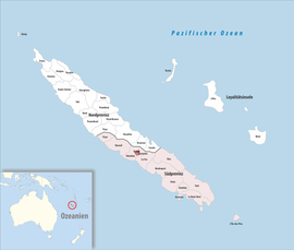
Sarraméa is a landlocked commune in the South Province of New Caledonia, an overseas territory of France in the Pacific Ocean. It and neighbouring Farino are the only two communes on the island that do not border the sea. With a population of 500, Sarraméa is the least populous commune of not only South Province, but all of New Caledonia.

Autrecourt-et-Pourron is a commune in the Ardennes department in the Grand Est region of northern France.

Ardeuil-et-Montfauxelles is a commune in the Ardennes department in the Grand Est region of northern France.

Varces-Allières-et-Risset is a commune in the Isère department in southeastern France. It is part of the Grenoble urban unit (agglomeration). It was created in 1955 by the merger of the former communes Varces and Allières-et-Risset.
Aboncourt is a commune in the Meurthe-et-Moselle department in northeastern France.
Agnicourt-et-Séchelles is a commune in the department of Aisne in the Hauts-de-France region of northern France.

Cœuvres-et-Valsery is a commune in the Aisne department in Hauts-de-France in northern France. The town is in the Arrondissement of Soissons.

Vendresse-Beaulne is a commune in the Aisne department in Hauts-de-France in northern France.

Crépey is a commune in the Meurthe-et-Moselle department in north-eastern France.

A Commune is the third-level administrative unit in Mali. Mali is divided into eight regions and one capital district (Bamako). These subdivisions bear the name of their principal city. The regions are divided into 49 Cercles. The Cercles and the district are divided into 703 Communes, with 36 Urban Communes and 667 Rural Communes, while some larger Cercles still contain Arrondissements above the Commune level, these are organisational areas with no independent power or office. Rural Communes are subdivided in Villages, while Urban Communes are subdivided into Quartier. Communes usually bear the name of their principal town. The capital, Bamako, consists of six Urban Communes. There were initially 701 communes until the Law No. 01-043 of 7 June 2001 created two new Rural Communes in the desert region in the north east of the country: Alata, Ménaka Cercle in the Gao Region and Intadjedite, Tin-Essako Cercle in the Kidal Region.

The communes of Ivory Coast are a fifth-level administrative unit of administration in Ivory Coast. The sub-prefectures of Ivory Coast contain villages, and in select instances more than one village is combined into a commune. There are currently 197 communes in the 510 sub-prefectures.