Lac-Chicobi

Last updated

Lac-Chicobi
Lac-Chicobi Quebec location diagram.png
Location within Abitibi RCM.
Canada Western Quebec location map.png
Red pog.svg
Lac-Chicobi
Location in western Quebec.
Coordinates: 48°53′N78°30′W / 48.883°N 78.500°W / 48.883; -78.500 [1]
CountryCanada
Province Quebec
Region Abitibi-Témiscamingue
RCM Abitibi
ConstitutedJanuary 1, 1986
Government
[2]
   Federal riding Abitibi—Témiscamingue
   Prov. riding Abitibi-Ouest
Area
  Total740.20 km2 (285.79 sq mi)
  Land716.01 km2 (276.45 sq mi)
Population
 (2021) [3]
  Total161
  Density0.2/km2 (0.5/sq mi)
  Pop 2006-2011
Increase2.svg 18.4%
  Dwellings
81
Time zone UTC−05:00 (EST)
  Summer (DST) UTC−04:00 (EDT)
Postal Code
J0Y 1L0
Area code 819
HighwaysNo major routes

Lac-Chicobi is an unorganized territory in the Canadian province of Quebec, located within the Abitibi Regional County Municipality. The area consists of two non-contiguous portions on either side of the incorporated municipality of Berry. [4]

The area had a population of 161 in the 2021 Canadian Census, and a land area of 716.01 km2 (276.45 sq mi). [3]

The eponymous Lake Chicobi is roughly in the centre of the territory's western portion. It is fed by the Authier and Chicobi Rivers and drained by the Octave River, a tributary of the Harricana River. The lake's name, in the past also spelled as Chikobi, Chikobee, and Cikobi, comes from a First Nations word meaning "where there are no islands". The Tanginan and Chicobi Hills are two prominent hills south-west of the lake, reaching an altitude of 441 m (1,447 ft). [5]

South of Lake Chicobi is the community of Guyenne ( 48°46′41″N78°28′13″W / 48.77806°N 78.47028°W / 48.77806; -78.47028 (Guyenne) ), the territory's only population centre. It is named after the geographic township of Guyenne (proclaimed in 1916), in turn named for the Régiment de Guyenne that fought under General Montcalm's command. [6]

Demographics

Population: [7]

Private dwellings occupied by usual residents: 71 (total dwellings: 81)

Related Research Articles

<span class="mw-page-title-main">Saguenay–Lac-Saint-Jean</span> Région in Quebec, Canada

Saguenay–Lac-Saint-Jean is a region in Quebec, Canada. It contains the Saguenay Fjord, the estuary of the Saguenay River, stretching through much of the region. It is also known as Sagamie in French, from the first part of "Saguenay" and the last part of "Piekouagami", the Innu name for Lac Saint-Jean, with the final "e" added to follow the model of other existing region names such as Mauricie, Témiscamie, Jamésie, and Matawinie. With a land area of 98,712.71 km2, Saguenay–Lac-Saint-Jean is the third-largest Quebec region after Nord-du-Québec and Côte-Nord.

<span class="mw-page-title-main">Mirabel, Quebec</span> City in Canada

Mirabel is a suburb of Montreal, located on the North Shore in southern Quebec.

<span class="mw-page-title-main">Harrington, Quebec</span> Township municipality in Quebec, Canada

Harrington is a township municipality in the Laurentides region of Quebec, Canada, part of the Argenteuil Regional County Municipality. It is located in the Laurentian Mountains, about 40 kilometres (25 mi) north-west of Lachute.

<span class="mw-page-title-main">Wentworth, Quebec</span> Township municipality in Quebec, Canada

Wentworth is a township municipality in the Laurentides region of Quebec, Canada, part of the Argenteuil Regional County Municipality, north-west of Lachute.

<span class="mw-page-title-main">Lac-Nilgaut</span> Unorganized territory in Quebec, Canada

Lac-Nilgaut is a large unorganized territory in the Outaouais region, Quebec, Canada. With a surface area of 9,851 km2 (3,803 sq mi), it makes up over 70% of the northern portion of Pontiac Regional County Municipality.

<span class="mw-page-title-main">Lac-Despinassy</span> Unorganized territory in Quebec, Canada

Lac-Despinassy is an unorganized territory in the Canadian province of Quebec, located within the Abitibi Regional County Municipality. The area is east of the municipality of Saint-Dominique-du-Rosaire, north of La Morandière-Rochebaucourt and the parish municipality of Senneterre, and west of the city of Senneterre.

<span class="mw-page-title-main">Pointe-des-Cascades, Quebec</span> Village municipality in Quebec, Canada

Pointe-des-Cascades is a village municipality in Vaudreuil-Soulanges Regional County Municipality in the Montérégie region of Quebec, Canada. It is located on a spit of land where the St. Lawrence River flows into Lake Saint-Louis. The river has here a significant drop, forming several cascades which give the village its name. The islands of Île des Cascades and Île des Joybert are connected by a narrow causeway, but Île des Cascades and Pointe-des-Cascades are only connected artificially.

<span class="mw-page-title-main">Saint-Joseph-du-Lac</span> Municipality in Quebec, Canada

Saint-Joseph-du-Lac is a municipality in the Laurentides region of Quebec, Canada, part of the Deux-Montagnes Regional County Municipality.

<span class="mw-page-title-main">Sainte-Anne-du-Lac</span> Municipality in Quebec, Canada

Sainte-Anne-du-Lac is a municipality and village in the Laurentides region of Quebec, Canada, part of the Antoine-Labelle Regional County Municipality.

<span class="mw-page-title-main">La Minerve, Quebec</span> Municipality in Quebec, Canada

La Minerve is a village and municipality in the Laurentides region of Quebec, Canada, part of the Les Laurentides Regional County Municipality.

<span class="mw-page-title-main">Fossambault-sur-le-Lac</span> City in Quebec, Canada

Fossambault-sur-le-Lac is a city in the south part of Quebec, Canada, in La Jacques-Cartier Regional County Municipality, just north of Quebec City. It had a population of 2,327 as of the Canada 2021 Census. It is located near Saint-Joseph Lake.

<span class="mw-page-title-main">Métabetchouan–Lac-à-la-Croix</span> City in Quebec, Canada

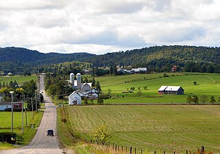
Métabetchouan–Lac-à-la-Croix is a city in Quebec, Canada, in the Saguenay–Lac-Saint-Jean region.

<span class="mw-page-title-main">Saint-Léon-le-Grand, Bas-Saint-Laurent</span> Parish municipality in Quebec, Canada

Saint-Léon-le-Grand is a parish municipality in Quebec, Canada.

<span class="mw-page-title-main">Lac-Masketsi</span> Unorganized territory in Quebec, Canada

Lac-Masketsi is an unorganized territory in the Mauricie region of province of Quebec, Canada, part of the Mékinac Regional County Municipality. Most of its area is part of the Zec Tawachiche. The discharge of Masketsi Lake at the south-east flows in the Little Lake Masketsi, which empties into the Tawachiche West River.

<span class="mw-page-title-main">Lac-Ashuapmushuan, Quebec</span> Unorganized territory in Quebec, Canada

Lac-Ashuapmushuan is an unorganized territory in the Canadian province of Quebec, Canada, located in the regional county municipality of Le Domaine-du-Roy. The region had a population of 140 as of the Canada 2021 Census, and covered a land area of 14,684.28 km2. It is home to the Ashuapmushuan Wildlife Reserve.

<span class="mw-page-title-main">Passes-Dangereuses</span> Unorganized territory in Quebec, Canada

Passes-Dangereuses is an unorganized territory in the Canadian province of Quebec, located between the Peribonka River on the east and the Mistassibi River on the west.

<span class="mw-page-title-main">Lac-Pikauba, Quebec</span> Unorganized territory in Quebec, Canada

Lac-Pikauba is an unorganized territory in the Capitale-Nationale region of Quebec, Canada. It is a large, unpopulated, undeveloped territory that makes up two-thirds of the Charlevoix Regional County Municipality.

<span class="mw-page-title-main">Lac-Walker, Quebec</span> Unorganized territory in Quebec, Canada

Lac-Walker is an unorganized territory in the Côte-Nord region of Quebec, Canada. It makes up more than half of the Sept-Rivières Regional County Municipality.

<span class="mw-page-title-main">Lac-Matapédia, Quebec</span> Unorganized territory in Quebec, Canada

Lac-Matapédia is an unorganized territory in the Bas-Saint-Laurent region of Quebec, Canada. It is named after and located on the northern shores of Lake Matapedia in the Matapédia Valley.

<span class="mw-page-title-main">Lac-Casault, Quebec</span> Unorganized territory in Quebec, Canada

Lac-Casault is an unorganized territory in the Bas-Saint-Laurent region of Quebec, Canada.

References

  1. "Banque de noms de lieux du Québec: Reference number 149737". toponymie.gouv.qc.ca (in French). Commission de toponymie du Québec.
  2. 1 2 "Lac-Chicobi". Répertoire des municipalités (in French). Ministère des Affaires municipales, des Régions et de l'Occupation du territoire. Retrieved 2011-01-10.
  3. 1 2 3 "Lac-Chicobi census profile". 2021 Census data . Statistics Canada. Retrieved 2022-03-18.
  4. GeoSearch 2006
  5. "Lac Chicobi" (in French). Commission de toponymie du Québec. Retrieved 2011-01-10.
  6. "Guyenne (canton)" (in French). Commission de toponymie du Québec. Retrieved 2011-01-10.
  7. Statistics Canada: 1996, 2001, 2006, 2011, 2016, 2021 census