Barraute

Last updated

Barraute
EgliseBarraute.JPG
Barraute Quebec location diagram.png
Location within Abitibi RCM
Canada Western Quebec location map.png
Red pog.svg
Barraute
Location in western Quebec
Coordinates: 48°26′N77°38′W / 48.433°N 77.633°W / 48.433; -77.633 [1]
CountryCanada
Province Quebec
Region Abitibi-Témiscamingue
RCM Abitibi
Settled1910s
ConstitutedJanuary 5, 1994
Government
[2]
  MayorJosseline Lepage
   Federal riding Abitibi—Témiscamingue
   Prov. riding Abitibi-Ouest
Area
  Total507.79 km2 (196.06 sq mi)
  Land493.04 km2 (190.36 sq mi)
Population
 (2021) [3]
  Total1,986
  Density4.0/km2 (10/sq mi)
  Pop (2016-21)
Increase2.svg 0.9%
  Dwellings
1,012
Time zone UTC−05:00 (EST)
  Summer (DST) UTC−04:00 (EDT)
Postal code(s)
Area code 819
HighwaysQc386.svg R-386 Qc397.svg R-397
Website Official website OOjs UI icon edit-ltr-progressive.svg

Barraute is a municipality in the Canadian province of Quebec, located in the Abitibi Regional County Municipality.

Contents

It is home to the Mont-Vidéo Ski Resort. [4]

History

Colonization began after the completion of the National Transcontinental Railway through the Abitibi region. In 1916, the family of Uldéric Hardy arrived, followed by a further 20 in 1917 and, by 1918, the place had a total of some 30 families. The new settlement was initially called Natagan, taken from the Natagan River, a First Nations name that means "winding waters." In 1917, the Natagan River Post Office opened, renamed to Barraute in 1919. [1]

In 1918, the United Township Municipality of Fiedmont-et-Barraute was formed, incorporating the geographic townships of Fiedmont and Barraute (proclaimed in 1916). Pierre-Jean Bachoie, called Barraute (1723-1760), was an officer of the Régiment de Béarn in the army of General Montcalm and member of the Order of Saint Louis. Fiedmont likewise was an officer of the army of Montcalm. [1]

In 1948, a portion of the municipal territory separated and was incorporated as the Village Municipality of Barraute. In 1950, zinc and silver mines began operating, that in addition to its favourable location along the railroad and Laflamme River (a tributary of the Bell River), contributed to the local prosperity. In 1951, the United Township Municipality of Fiedmont-et-Barraute changed status to just municipality. But the closure of the zinc and silver mines in 1957, as well as the closure in 1965 of Canada's only lithium mine in neighbouring La Corne, dealt a blow to the economy of Barraute. [1]

In 1978, the Town of Barville (incorporated in 1953) was merged into the Municipality of Fiedmont-et-Barraute and, in 1994, the Municipalities of Fiedmont-et-Barraute and Barraute were regrouped into the new Municipality of Barraute. [1]

Demographics

Historical census populations – Barraute
YearPop.±%
1991 2,200    
1996 2,134−3.0%
2001 2,010−5.8%
2006 2,062+2.6%
YearPop.±%
2011 1,980−4.0%
2016 1,968−0.6%
2021 1,986+0.9%
Source: Statistics Canada

Private dwellings occupied by usual residents (2021): 930 (total dwellings: 1,012) [3]

Mother tongue (2021): [3]

Economy

In 2012, Quebec Lithium Corp. reopened Quebec Lithium Mine, which had operated as an underground mine from 1955 to 1965. They are planning to carve an open pit mine over pegmatite dikes. (The pegmatite is about 1% lithium carbonate.) The mine is about 60 km (37 mi) north of Val-d'Or, 38 km (24 mi) southeast of Amos, and 15 km (9.3 mi) west of Barraute. Access to the mine is via paved road from Val-d'Or. [5]

Government

Municipal council (as of 2024): [2]

See also

Related Research Articles

<span class="mw-page-title-main">Rouyn-Noranda</span> City in Quebec, Canada

Rouyn-Noranda is a city on Osisko Lake in the Abitibi-Témiscamingue region of Quebec, Canada.

<span class="mw-page-title-main">Val-d'Or</span> City in Quebec, Canada

Val-d'Or is a city in Quebec, Canada with a population of 32,752 inhabitants according to the 2021 Canadian census. The city is located in the Abitibi-Témiscamingue region near La Vérendrye Wildlife Reserve.

<span class="mw-page-title-main">Abitibi-Témiscamingue</span> Administrative region in Quebec, Canada

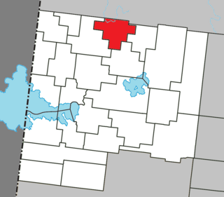
Abitibi-Témiscamingue is an administrative region located in western Québec, Canada, along the border with Ontario. It became part of the province in 1898. It has a land area of 57,736.50 square kilometres (22,292.19 sq mi) and its population was 147,082 people as of the 2021 census. The region is divided into five regional county municipalities and 79 municipalities. Its economy continues to be dominated by resource extraction industries. These include logging and mining all along the rich geologic Cadillac Fault between Val-d'Or and Rouyn-Noranda, as well as agriculture.

<span class="mw-page-title-main">Amos, Quebec</span> Town in Quebec, Canada

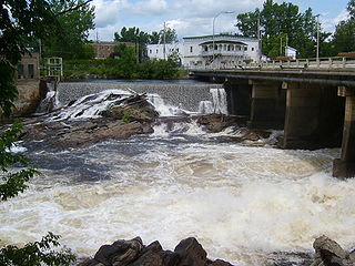
Amos is a town in northwestern Quebec, Canada, on the Harricana River. It is the seat of Abitibi Regional County Municipality.

<span class="mw-page-title-main">Mont-Laurier</span> City in Quebec, Canada

Mont-Laurier is a town and incorporated municipality in northwest Quebec, Canada, located on the banks of the Lièvre River, a tributary of the Ottawa River. Known as the "Capital of the Haute-Laurentides", the motto of the town is Laurus elationis praemium, which translates to "Lift the laurels of reward". The demonym for its inhabitants is Lauriermontois.

<span class="mw-page-title-main">Malartic, Quebec</span> City in Quebec, Canada

Malartic is a town on the Malartic River in northwestern Quebec, Canada, in the La Vallée-de-l'Or Regional County Municipality. It is located about 80 kilometres (50 mi) east of the centre of Rouyn-Noranda along Quebec Route 117 and the Canadian National Railway.

<span class="mw-page-title-main">Senneterre</span> City in Quebec, Canada

Senneterre is a town in the Abitibi-Témiscamingue region of northwestern Quebec, Canada. It is in La Vallée-de-l'Or Regional County Municipality.

<span class="mw-page-title-main">Saint-Donat, Lanaudière, Quebec</span> Municipality in Quebec, Canada

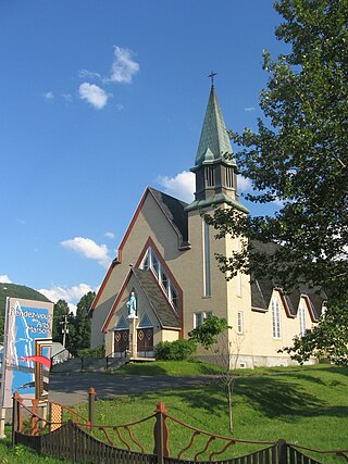
Saint-Donat is a township municipality in the Canadian province of Quebec, part of the Regional County Municipality of Matawinie, within the larger administrative region of Lanaudière. The main town within the township is also identified as Saint-Donat-de-Montcalm to distinguish it from a parish municipality with the same name in La Mitis RCM. It is located approximately 135 kilometres (84 mi) northwest of Montreal. The town is surrounded by mountains and numerous water basins of the Laurentian Mountains. The nearest natural landmark is the Mont-Tremblant National Park.

<span class="mw-page-title-main">Lebel-sur-Quévillon</span> City in Quebec, Canada

Lebel-sur-Quévillon is a city in the Canadian province of Quebec, located on Route 113 in the Jamésie region. It is located approximately 88 kilometres north of Senneterre and approximately 200 kilometres southwest of Chibougamau. It is surrounded by, but not a part of, the local municipality of Eeyou Istchee James Bay. It is constituted from unorganized territories.

<span class="mw-page-title-main">La Corne</span> Municipality in Quebec, Canada

La Corne is a municipality in the Canadian province of Quebec in Abitibi Regional County Municipality.

<span class="mw-page-title-main">La Motte, Quebec</span> Municipality in Quebec, Canada

La Motte is a municipality in the Canadian province of Quebec, located in the Abitibi Regional County Municipality and the administrative region of Abitibi-Témiscamingue.

<span class="mw-page-title-main">Preissac</span> Municipality in Quebec, Canada

Preissac is a municipality in the Canadian province of Quebec, located in the Abitibi Regional County Municipality. The village of Preissac itself is located at the north end of Lake Preissac.

<span class="mw-page-title-main">Macamic</span> City in Quebec, Canada

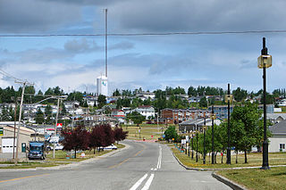
Macamic is a ville in northwestern Quebec, Canada, in the Abitibi-Ouest Regional County Municipality. It covers 202 km² and had a population of 2,744 in the 2021 Canadian census. It is located on the shores of the namesake Lake Macamic.

<span class="mw-page-title-main">Val-Saint-Gilles</span> Municipality in Quebec, Canada

Val-Saint-Gilles is a municipality in northwestern Quebec, Canada, in the Abitibi-Ouest Regional County Municipality about 24 kilometres (15 mi) north of La Sarre. It covers 109.39 km² and with a population of 169 in the 2021 Canadian census, it is the least populous incorporated municipality in the regional county.

<span class="mw-page-title-main">Beaupré, Quebec</span> City in Quebec, Canada

Beaupré is a ville in the Canadian province of Quebec, located in La Côte-de-Beaupré Regional County Municipality. The town is along the Saint Lawrence River and Route 138 at the mouth of the Sainte-Anne-du-Nord River.

<span class="mw-page-title-main">Lac-Chicobi</span> Unorganized territory in Quebec, Canada

Lac-Chicobi is an unorganized territory in the Canadian province of Quebec, located within the Abitibi Regional County Municipality. The area consists of two non-contiguous portions on either side of the incorporated municipality of Berry.

<span class="mw-page-title-main">Val-Morin</span> Municipality in Quebec, Canada

Val-Morin is a municipality in the Laurentides region of Quebec, Canada, part of the Les Laurentides Regional County Municipality.

<span class="mw-page-title-main">Sainte-Anne-du-Lac</span> Municipality in Quebec, Canada

Sainte-Anne-du-Lac is a municipality and village in the Laurentides region of Quebec, Canada, part of the Antoine-Labelle Regional County Municipality.

<span class="mw-page-title-main">Mont-Saint-Michel, Quebec</span> Municipality in Quebec, Canada

Mont-Saint-Michel is a municipality in the Laurentides region of Quebec, Canada, part of the Antoine-Labelle Regional County Municipality.

<span class="mw-page-title-main">Marsoui, Quebec</span> Village municipality in Quebec, Canada

Marsoui is a village municipality in the Gaspésie–Îles-de-la-Madeleine region of Quebec, Canada.

References

  1. 1 2 3 4 5 "Barraute (Municipalité)" (in French). Commission de toponymie du Québec. Retrieved 2011-01-11.
  2. 1 2 3 "Barraute". Répertoire des municipalités (in French). Ministère des Affaires municipales et de l'Habitation. Retrieved 2023-07-21.
  3. 1 2 3 4 "Barraute census profile". 2021 Census data . Statistics Canada. Retrieved 2023-04-06.
  4. "Mont-Vidéo ski maps". skimap.org. Retrieved 2013-03-07.
  5. "Quebec Lithium". Canada Lithium Corp. Archived from the original on 2013-03-10. Retrieved 2013-03-07.