Preissac

Last updated

Preissac
Preissac QC 1.JPG
Preissac Quebec location diagram.png
Location within Abitibi RCM
Canada Western Quebec location map.png
Red pog.svg
Preissac
Location in western Quebec
Coordinates: 48°24′N78°22′W / 48.400°N 78.367°W / 48.400; -78.367 [1]
CountryCanada
Province Quebec
Region Abitibi-Témiscamingue
RCM Abitibi
Settled1934
ConstitutedJanuary 1, 1979
Government
[2]
  MayorDonald Rheault
   Federal riding Abitibi—Témiscamingue
   Prov. riding Abitibi-Ouest
Area
  Total506.29 km2 (195.48 sq mi)
  Land422.13 km2 (162.99 sq mi)
Population
 (2021) [3]
  Total914
  Density2.2/km2 (6/sq mi)
  Pop (2016-21)
Increase2.svg 9.5%
  Dwellings
527
Time zone UTC−05:00 (EST)
  Summer (DST) UTC−04:00 (EDT)
Postal code(s)
Area code 819
HighwaysQc395.svg R-395
Website www.preissac.com OOjs UI icon edit-ltr-progressive.svg

Preissac is a municipality in the Canadian province of Quebec, located in the Abitibi Regional County Municipality. The village of Preissac itself is located at the north end of Lake Preissac.

Contents

It is named after Lambert Preissac de Cadeihan, a lieutenant in the Régiment de Berry that was part of General Montcalm's army. [1]

History

Demographics

Historical census populations – Preissac
YearPop.±%
1981 453    
1986 455+0.4%
1991 529+16.3%
1996 619+17.0%
2001 684+10.5%
YearPop.±%
2006 726+6.1%
2011 786+8.3%
2016 835+6.2%
2021 914+9.5%
Source: Statistics Canada

Private dwellings occupied by usual residents (2021): 430 (total dwellings: 527) [3]

Mother tongue (2021): [3]

Government

Municipal office Preissac QC 2.JPG
Municipal office

Municipal council (as of 2023): [2]

List of former mayors:

Related Research Articles

<span class="mw-page-title-main">Rouyn-Noranda</span> City in Quebec, Canada

Rouyn-Noranda is a city on Osisko Lake in the Abitibi-Témiscamingue region of Quebec, Canada.

<span class="mw-page-title-main">Val-d'Or</span> City in Quebec, Canada

Val-d'Or is a city in Quebec, Canada with a population of 32,752 inhabitants according to the 2021 Canadian census. The city is located in the Abitibi-Témiscamingue region near La Vérendrye Wildlife Reserve.

<span class="mw-page-title-main">Amos, Quebec</span> Town in Quebec, Canada

Amos is a town in northwestern Quebec, Canada, on the Harricana River. It is the seat of Abitibi Regional County Municipality.

<span class="mw-page-title-main">Val-des-Sources</span> Town in Quebec, Canada

Val-des-Sources, meaning "Valley of the Springs", formerly known as Asbestos, is a town on the Nicolet River in the Estrie region of southeastern Quebec, Canada. The town is the seat of Les Sources Regional County Municipality, formerly known as the Asbestos Regional County Municipality. The town covers an area of 30.25 square kilometres, including land acquired due to the merger of the City of Asbestos with the Municipality of Trois-Lacs on December 8, 1999.

<span class="mw-page-title-main">Senneterre</span> City in Quebec, Canada

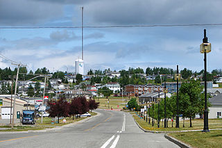
Senneterre is a town in the Abitibi-Témiscamingue region of northwestern Quebec, Canada. It is in La Vallée-de-l'Or Regional County Municipality.

<span class="mw-page-title-main">Val-Brillant</span> Municipality in Quebec, Canada

Val-Brillant is a municipality in eastern Quebec, Canada, at the base of the Gaspé peninsula. On the southern shores of the Lake Matapedia, Val-Brillant is part of the Matapédia Valley.

<span class="mw-page-title-main">Lebel-sur-Quévillon</span> City in Quebec, Canada

Lebel-sur-Quévillon is a city in the Canadian province of Quebec, located on Route 113 in the Jamésie region. It is located approximately 88 kilometres north of Senneterre and approximately 200 kilometres southwest of Chibougamau. It is surrounded by, but not a part of, the local municipality of Eeyou Istchee James Bay. It is constituted from unorganized territories.

<span class="mw-page-title-main">Notre-Dame-de-Montauban</span> Municipality in Quebec, Canada

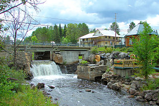
Notre-Dame-de-Montauban is a municipality in the Mauricie region in Quebec, Canada. The municipality is on the northern edge of Mékinac Regional County Municipality and the administrative region of Mauricie and includes the population centres of Notre-Dame-des-Anges and Montauban-les-Mines. Both communities are located along route 367 and are about 7 kilometres (4.3 mi) apart.

<span class="mw-page-title-main">Barraute</span> Municipality in Quebec, Canada

Barraute is a municipality in the Canadian province of Quebec, located in the Abitibi Regional County Municipality.

<span class="mw-page-title-main">La Corne</span> Municipality in Quebec, Canada

La Corne is a municipality in the Canadian province of Quebec in Abitibi Regional County Municipality.

<span class="mw-page-title-main">La Motte, Quebec</span> Municipality in Quebec, Canada

La Motte is a municipality in the Canadian province of Quebec, located in the Abitibi Regional County Municipality and the administrative region of Abitibi-Témiscamingue.

<span class="mw-page-title-main">Sainte-Gertrude-Manneville</span> Municipality in Quebec, Canada

Sainte-Gertrude-Manneville is a municipality in the Canadian province of Quebec, located in Abitibi Regional County Municipality. It includes the population centres of Sainte-Gertrude-de-Villeneuve and Manneville.

<span class="mw-page-title-main">Landrienne</span> Township municipality in Quebec, Canada

Landrienne is a township municipality in the Canadian province of Quebec, located in the Abitibi Regional County Municipality. It is part of the census agglomeration of Amos.

<span class="mw-page-title-main">Aumond</span> Township municipality in Quebec, Canada

Aumond is a township municipality in the Canadian province of Quebec, located within La Vallée-de-la-Gatineau Regional County Municipality.

<span class="mw-page-title-main">Denholm, Quebec</span> Municipality in Quebec, Canada

Denholm is a municipality in La Vallée-de-la-Gatineau Regional County Municipality, Quebec, Canada, 40 kilometres (25 mi) north of Gatineau. Its territory is along the eastern shores of Lake Sainte Marie, part of the Gatineau River.

<span class="mw-page-title-main">Sainte-Anne-du-Lac</span> Municipality in Quebec, Canada

Sainte-Anne-du-Lac is a municipality and village in the Laurentides region of Quebec, Canada, part of the Antoine-Labelle Regional County Municipality.

<span class="mw-page-title-main">Lac-du-Cerf</span> Municipality in Quebec, Canada

Lac-du-Cerf is a municipality in the Laurentides region of Quebec, Canada, part of the Antoine-Labelle Regional County Municipality. It is located on and named after Lac du Cerf.

<span class="mw-page-title-main">Lac-des-Écorces, Quebec</span> Municipality in Quebec, Canada

Lac-des-Écorces is a municipality and village in the Laurentides region of Quebec, Canada, part of the Antoine-Labelle Regional County Municipality.

<span class="mw-page-title-main">Lac-Saint-Paul, Quebec</span> Municipality in Quebec, Canada

Lac-Saint-Paul is a municipality in the Laurentides region of Quebec, Canada, part of the Antoine-Labelle Regional County Municipality.

<span class="mw-page-title-main">Chambord, Quebec</span> Municipality in Quebec, Canada

Chambord is a municipality in Le Domaine-du-Roy Regional County Municipality in the Saguenay–Lac-Saint-Jean region of Quebec, Canada. The Chambord meteorite was found near here in 1904.

References

  1. 1 2 3 4 "Preissac (Municipalité)" (in French). Commission de toponymie du Québec. Retrieved 2011-01-10.
  2. 1 2 3 "Preissac". Répertoire des municipalités (in French). Ministère des Affaires municipales et de l'Habitation. Retrieved 2023-07-26.
  3. 1 2 3 4 "Preissac community profile". 2021 Census data . Statistics Canada. Retrieved 2023-06-08.
  4. "Long Lac officially opens Bousquet". The Val d'Or Star. July 4, 1979. p. 17. ISSN   1184-4981 . Retrieved July 1, 2010.
  5. "Long Lac Mineral Exploration Ltd Mines De Bousquet". The Val d'Or Star. July 4, 1979. p. 13. ISSN   1184-4981 . Retrieved July 1, 2010.[ dead link ]