A township (French: canton) in Quebec, Canada, is a cadastral division of the land. The township system was implemented by the British government to facilitate the granting of public lands for settlement by populations of European background, particularly Loyalists from the American Revolution. Townships were initially also a unit of local government, but that is no longer the case. Townships are now used solely for land description and do not have a governmental function.
In the Quebec system, townships for the most part are approximately 10 miles by 10 miles square, except for those located on the banks of a navigable waterway which are 9 miles abreast and 12 miles deep.
Creation of the township system
Under the seigneurial system of land holdings in force in New France, a local lord, or "seigneur" had overall control of a large area of land. Individuals who held plots of land within the seigneury had to pay seigneurial duties to the local seigneur.
Post-conquest, the British colonial government instituted the township system of land-holding. It was based on English land law, using the tenure of "free and common socage", which did not require seigneurial levies.[1] Following the arrival of Loyalists fleeing the American Revolution, the British Parliament enacted the Constitutional Act, 1791, which introduced this form of land tenure in both Lower Canada and Upper Canada.[1][2] After the passage of the Act, the British government instructed the Governor to grant land in townships, which was subsequently set out by a proclamation of Lieutenant Governor Clarke in 1792.[3]
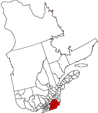
The township of Dunham was the first township established in Quebec, on February 2, 1796, in the region which came to be known as the "Eastern Townships of Lower Canada" (cantons de l'Est du Bas-Canada), as opposed to the "Western Townships of Upper Canada".[4][5] The Eastern Townships also form a historic region. Collectively, they constituted the bloc of the first townships created in what is now Quebec, before the final replacement of the seigneurial regime in 1854. The Eastern Townships include the whole of the Estrie administrative region, and parts of the administrative regions of Centre-du-Québec, Chaudière-Appalaches and Montérégie.
Abolition of seigneurial tenure
In 1854, the Parliament of the Province of Canada abolished the system of seigneurial tenure, converting all former seigneurial tenures to franc-aleu roturier.[6] The subsequent amending act provided for the creation of new townships in new regions, in addition to the existing eastern townships.[1][7] Later, several other areas were divided into townships before being settled, such as Abitibi-Témiscamingue, Saguenay-Lac-Saint-Jean, and Côte-Nord.[1]
The Quebec cadastre is still divided into townships today. According to the system of distribution of the lots, they organize, together with the provisions relating to agricultural land and protected areas, the development and location of new urbanization plans, in rural and semi-rural regions.[9] Within the urban centres, the maintenance of the current townships serves to organize the municipal development of highways and therefore, to promote respect for acquired rights relating to the ownership of lots.
On the other hand, the township system in Quebec constitutes a main premise in the attribution of the relative responsibility.
Main characteristics of the Quebec township
For the most part, townships are approximately 10 miles by 10 miles square (16 km by 16 km), except for those located on the banks of a navigable waterway which are 9 miles abreast and 12 miles deep (14 km by 19 km).[1]
The Eastern Townships is a historical administrative region in southeastern Quebec, Canada. It lies between the St. Lawrence Lowlands and the American border, and extends from Granby in the southwest to Drummondville in the northeast. Since 1987, most of the area is within the administrative region Estrie, and the term Eastern Townships is now used in tourist literature.
Notre Dame, French for "Our Lady", a title of Mary, mother of Jesus, most commonly refers to:
Saint-Georges is a city in the province of Quebec, Canada. It is the seat of Beauce-Sartigan Regional County Municipality, part of the Chaudière-Appalaches region. The population was 32,935 as of the Canada 2021 Census. Route 173 runs through Saint-Georges Est and heads south to the border with Maine, United States.
The Chaudière River is a 185-kilometre-long (115 mi) river with its source near the Town of Lac-Mégantic, in southeast Quebec, Canada. From its source Lake Mégantic in the Estrie region, it runs northwards to flow into the St. Lawrence River opposite Quebec City.
The Canadian province of Quebec held municipal elections in its municipalities on November 6, 2005.
These are lists of people from Quebec by region.
The Province of Quebec is divided into entities that deliver local government, along with other types of functional divisions.
Saint-Édouard may refer to:
The Shields Branch is a tributary of the Big Black River, flowing in:
Saint-Marcel is a municipality in Quebec located in the MRC de L'Islet in the Chaudière-Appalaches.
A regional conference of representatives was a type of governance in an administrative region of Quebec.
The Gobeil River is a tributary of the Big Black River, flowing through:
Noire River or Rivière Noire may refer to:
Expo Québec was an annual fair that took place in Quebec City in mid to late August from 1897 to 2015.
Rivière du Sud may refer to:
The Ludgine River is a tributary of the west bank of the Chaudière River which flows northward to empty onto the south shore of the St. Lawrence River.
This page is based on this Wikipedia article Text is available under the CC BY-SA 4.0 license; additional terms may apply. Images, videos and audio are available under their respective licenses.