Lady's Well, Auchmannoch

Last updated

Lady's Well
The Lady's Well full Cross view, Auchmannoch, Near Sorn, East Ayrshire.jpg
The Lady's Well and Cross at the Stra Burn Ford, Auchmannoch
East Ayrshire UK location map.svg
Red pog.svg
Lady's Well
Location within East Ayrshire
Council area
Country Scotland
Sovereign state United Kingdom
Post town Kilmarnock
Police Scotland
Fire Scottish
Ambulance Scottish
List of places
UK
Scotland
55°33′00″N4°18′24″W / 55.5499°N 4.3068°W / 55.5499; -4.3068

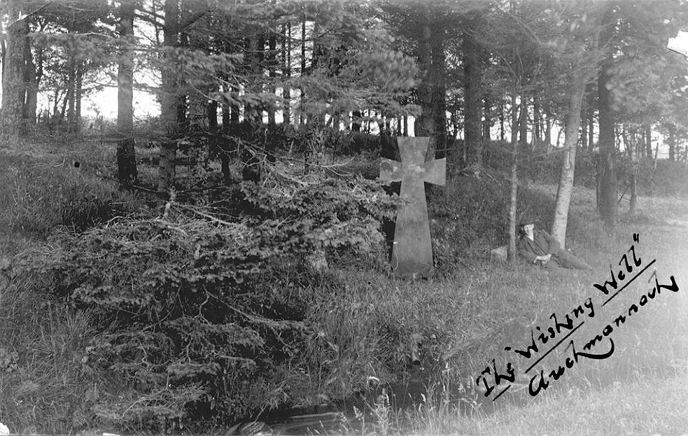
The Lady's Well is a natural spring surmounted by a large cross that stands beside the Stra Burn Ford (NS254630) near Auchmannoch House in the Parish of Sorn, East Ayrshire, Scotland. It is associated with the Virgin Mary as a curative well, [1] a Wishing Well and also a Clootie well, additionally Mary Queen of Scots is said to have once watered her horse here. A large red sandstone cross was erected here at an unrecorded date. [2] The well is also said to have acquired its name through "..one of the ladies of Auchmannoch family drinking water exclusively from here." [3]

Contents

History

The inscription on the cross is 'The Lady's Well and the date AD 1258 is carved below it. The Lady's Well Cross, Auchmannoch, Near Sorn, East Ayrshire.jpg
The inscription on the cross is 'The Lady's Well and the date AD 1258 is carved below it.

In the 12th century a grant of lands including Auchmannoch was made to the monks of Melrose Abbey by Alan, the High Steward. [4] Early in the 15th century a family of Campbells descended from the Campbells of Loudoun Castle held the lands from the church, a 1565 charter from the Commendator of Melrose shows that Campbell and Margaret Campbell renewed their possession of the 'Lands of Auchmannoch' in 1565 and held them from that point onward until 1919. [5] [6]

Auchmannoch stands on one of the oldest roads in the district, running once from Loudoun Castle via Cessnock Castle to Sorn Castle through Threepwood and Auchencloigh with the Stra Burn Ford and the Lady's Well on the route. [7]

The Ordnance Survey may contradict the fine detail of the story that Mary Queen of Scots watered her horses here once by stating that the 'Queen's Syke "..is a Small Stream or marsh forming a Junction with the Stra Burn about 13 chains N [North] east of Coplar. It is handed down by tradition which the Authorities here verify that Mary Queen of Scots with some of her attendants halted at this place on her passage of flight to England." [8] It is known that the queen stayed in the area after fleeing from the Battle of Langside. [9]

The Well and Cross

The substantial red sandstone cross is of an unknown date, almost certainly erected by the Campbells of Auchmannoch in the 19th century. It carries the inscription 'The Lady's Well' in flowing Old English script and also the date 'About AD 1258' representing when the lands were first granted to the Abbey of Melrose or possibly the date of the discovery of the well. [10] Postcards carry the inscription 'Wishing Well' and a pipe can be seen carrying the overflow flow from the well into the Stra Burn. [11] A substantial stone trough has been set into the ground with the cross at the top and a narrow secondary overflow appears to be present in addition to the aforementioned pipe that leads to the Stra Burn. A substantial amount of graffiti has been added to the cross over the years.

The stone trough and overflow. The Lady's Well spring, Auchmannoch, Near Sorn, East Ayrshire.jpg
The stone trough and overflow.

The construction of a new road nearby to Crofthead Farm, avoiding the passage through the Stra Burn Ford, cut off the water supply to this natural spring. [12] An old Sycamore grows next to the well and its cross.

The Lady's Well is said to have been a Clootie well, the practise dying out after WWII. [13] These 'Clootie wells' were places of pilgrimage in Celtic areas, almost always with a tree growing beside them where strips of cloth or rags were left, usually tied to the branches of the tree as part of a healing ritual. It is not recorded what ailments the holy water from the well was thought to heal. [14] In Scots nomenclature, a "clootie" or "cloot" is a strip of cloth or rag. Other offerings were also sometimes made at such sites, including coins, pins, white pebbles, etc [15] as is still the case at Saint Queran's Holy Well, Islesteps, near Dumfries. [16]

Etymology

It is thought that the name 'Auchmannoch' may translate from the Scots Gaelic 'Achadch Mannoch' as the 'Field of the Monks' linking with the 12th century grant of these lands to the monks of Melrose Abbey by Alan, the High Steward. [17] Millmannoch near Colylton may contain the same name element.

See also

Related Research Articles

<span class="mw-page-title-main">Thurgartstone</span> Glacial erratic stone near Dunlop, Scotland

The Thurgartstone or Ogrestone is a prominent glacial erratic stone near Dunlop in East Ayrshire, Scotland. The Thurgartstone stands in a field at Brandleside Farm and is thought to have been a rocking stone at one time, but it no longer moves due to a build up of soil beneath.

<span class="mw-page-title-main">Rowallan Castle</span>

Rowallan Castle is an ancient castle located in Scotland. The castle stands on the banks of the Carmel Water, which may at one time have run much closer to the low eminence upon which the original castle stood, justifying the old name Craig of Rowallan. Elizabeth Mure was mistress and then wife of Robert, High Steward of Scotland, and Guardian of Scotland, who later became King Robert II of Scotland. She may have been born at Rowallan.

Old Dailly is a hamlet in South Ayrshire, Scotland. It is located west of Dailly.

Riccarton is a village and parish in East Ayrshire, Scotland. It lies across the River Irvine from Kilmarnock, this river forming the boundary between Riccarton and Kilmarnock parishes, and also between the historical districts of Kyle and Cunningham. The name is a corruption of 'Richard's town', traditionally said to refer to Richard Wallace, the uncle of Sir William Wallace. The parish also contains the village of Hurlford.

<span class="mw-page-title-main">Carlin stone</span> Name of many stones in Scotland

Carlin Stone or Carline Stane is the name given to a number of prehistoric standing stones and natural stone or landscape features in Scotland. The significance of the name is unclear, other than its association with old hags, witches, and the legends of the Cailleach.

<span class="mw-page-title-main">Terringzean Castle, East Ayrshire</span>

Terringzean Castle, also Taringzean, pronounced 'Tringan', is a Category B listed castle ruin lying above the River Lugar and the Terringzean Holm in the policies of Dumfries House, Parish of Cumnock, Scotland. The name Craufordstone or Craufurdstoun, has also been used, echoing that it and these lands originally belonged to the Crawfords, as did Lefnoreis Castle or Lochnorris Castle which once stood near the site of the Dumfries House stables.

<span class="mw-page-title-main">Loch Fergus</span> Freshwater loch in South Ayrshire, Scotland

Loch Fergus is a freshwater post-glacial "Kettle Hole" sometimes recorded as Fergus Loch. It is quite visible and is situated in a low-lying area close to the B742 road between the farms and dwellings of Trees, Lochfergus and Bowmanston in the Parish of Ayr, South Ayrshire, Scotland. The loch lies to the north of Martnaham Loch, four miles east-southeast of Ayr. It drains to the southwest into the Snipe Loch.

<span class="mw-page-title-main">Polkelly Castle</span>

Polkelly Castle, also Pokelly, was an ancient castle located near Fenwick, at NS 4568 4524, in the medieval free Barony of Polkelly, lying north of Kilmarnock, Parish of Fenwick, East Ayrshire, Scotland. The castle is recorded as Powkelly (c1747), Pockelly (c1775), Pow-Kaillie, Ponekell, Polnekel, Pollockelly, Pollockellie, Pokellie, Pothelly, Pathelly Ha' and Polkelly. The name is given circa 1564 as Powkellie when it was held by the Cunninghams of Cunninghamhead.

The Maak's or Monk's Well is situated beside the Carmel Water in Kilmaurs, East Ayrshire., Scotland. A possible 'Holy Well', it was once a public water supply for the villagers and residents of the old castle at Kilmaurs Place.

<span class="mw-page-title-main">Wallace's Heel Well</span> Petrosomatoglyph in South Ayrshire, Scotland, UK

Wallace's Heel Well or Wallace's Heel is located beside the River Ayr (NS35502122) near the old Holmston lime kiln, Ayr, Scotland. It is a petrosomatoglyph said to represent the imprint of a heel and is associated with the story of an escape from English soldiers made by the Scottish hero William Wallace.

<span class="mw-page-title-main">Dunton Cove</span>

Dunton Cove or the Covenanters' Cave is an artificial cave in a craggy outcrop of rocks overlooking the Craufurdland Water just below the confluence of the Dunton Water and the Calf Fauld Water in East Ayrshire, Scotland, close to the village of Waterside. Traditionally it was used as a hiding place for Covenanters in the 17th century during the so-called 'Killing Times' of the 1680s.

<span class="mw-page-title-main">Peden's Cave (Auchinbay)</span>

Peden's Cave is at least partly artificial and is set into a craggy outcrop of red sandstone rocks overlooking the River Lugar just below the farm of Auchinbay in East Ayrshire, Scotland, close to the town of Ochiltree. Traditionally it is said that this cave was used as a hiding place for Covenanters, including the famous Covenanter minister Alexander Peden in the 17th century, mainly during the so-called 'Killing Times' of the 1680s.

<span class="mw-page-title-main">The Holy Cave, Hunterston</span>

The Holy Cave at Hunterston in the Parish of West Kilbride is associated with Saint Mungo, also known as St Kentigern and is often referred to as the Hawking Craig Cave however two caves exists in the Hawking Craig Wood and 'Three Sisters' area of the cliffs, the other being Smith's Cave, better described as a rock shelter lying a short distance to the south. The main cave has been excavated and the finds indicate three periods of occupation over many centuries.

<span class="mw-page-title-main">Wallace's Cave, Auchinleck</span>

Wallace's Cave in the Lugar Gorge at Auchinleck in the Parish of Auchinleck is an 18th-century grotto contemporary with Dr Johnson's Summerhouse, also located on the Auchinleck Estate. It shows superior workmanship in its construction, possibly being the enlargement of a pre-existing cave. The cave or grotto lies downstream of the confluence of the Dippol Burn with the River Lugar and is reached via a once well formed path, however access is now hazardous due to the condition of the cliff edge path and the vertical drop into the River Lugar.

<span class="mw-page-title-main">Bickering Bush</span> Scottish thorn near Caprington, linked to legend of Sir William Wallace

The Bickering bush (NS41863635) thorn grew near Caprington on the lands of Monksholm or Maxholm, Riccarton, East Ayrshire, Scotland. The old farm house at Maxholm sat in hollow on the old Caprington Castle estate and to the north and west its fields bordered the River Irvine. The thorn was located, as recorded on the OS map, near to the confluence of the Kilmarnock Water and the River Irvine, downstream of the Simon's Burn's confluence on the south bank of the river.

<span class="mw-page-title-main">Craigie, South Ayrshire</span> Human settlement in Scotland

Craigie is a small village and parish of 6,579 acres in the old district of Kyle, now South Ayrshire, four miles south of Kilmarnock, Scotland. This is mainly a farming district, lacking in woodland, with a low population density, and only one village. In the 19th century, high quality lime was quarried here with at least three sites in use in 1832.

<span class="mw-page-title-main">Murdoch's Cave</span>

Murdoch's Cave, is a relatively small artificial cave created by William Murdoch (1754-1839) and his siblings in the soft red sandstone Lugar river bank cliff just upstream of the old Bellow Mill close to the confluence of the Bellow or Bello Water and the Glenmuir Water in Lugar, East Ayrshire, Scotland. The spelling 'Bellow' is used for consistency.

<span class="mw-page-title-main">Minishant</span> Human settlement in Scotland

Minishant is a village bordering the A77 in the old county of Carrick, South Ayrshire, Scotland. It is located in Maybole Parish, 3+12 miles from Maybole and standing close to the River Doon. The village was originally named Culroy after the Culroy Burn that runs through it.

<span class="mw-page-title-main">Kyle Castle</span>

The ruins of the large courtyard style Kyle Castle, once also known as Cavil Castle or occasionally Dalblair Castle lie close to the hamlet of Dalblair in Auchinleck parish near Muirkirk in the East Ayrshire council area, Scotland. The castle stands at the confluence of the Guelt Water and the Glenmuir Water on a peninsula carved out by these rivers. Its name suggests that it was once of some significance.

<span class="mw-page-title-main">Balcreuchan Port</span>

Balcreuchan Port or Balcruachan Port (NX0908878) is a bay and raised beach site in the parish of Colmonell, close to Bennane Head and Port Vad (NX091870) in South Ayrshire, Scotland. It is well known for its cave (NX099876) with its links to the legend of Sawney Bean and also for the unusual geology that is found in the bay. It was a minor fishing harbour up until the mid to late 19th century.

References

Notes
  1. Love, Dane (2008). The History of Sorn Village and Parish. p. 52. ISBN   978-0-9518128-5-3.
  2. Love, Dane (2009). Legendary Ayrshire. Carn Publishing. p. 24. ISBN   978-0-9518128-6-0.
  3. "Ordnance Survey Name Books - Volume 55" . Retrieved 10 July 2017.
  4. Burke, John (1838). A genealogical and heraldic history of the commoners of Great Britain and Ireland. Henry Colburn. p. 14. ISBN   0-951812-81-5.
  5. Burke, John (1838). A genealogical and heraldic history of the commoners of Great Britain and Ireland. Henry Colburn. p. 14.
  6. Love, Dane (2008). The History of Sorn Village and Parish. p. 99. ISBN   978-0-9518128-5-3.
  7. Love, Dane (2008). The History of Sorn Village and Parish. p. 51. ISBN   978-0-9518128-5-3.
  8. "Ordnance Survey Name Books - Volume 55" . Retrieved 10 July 2017.
  9. Love, Dane (2009). Legendary Ayrshire. Carn Publishing. p. 24. ISBN   978-0-9518128-6-0.
  10. Love, Dane (2009). Legendary Ayrshire. Carn Publishing. p. 60. ISBN   978-0-9518128-6-0.
  11. "Ayrshirehistory.com" . Retrieved 10 July 2017.
  12. Love, Dane (2009). Legendary Ayrshire. Carn Publishing. p. 60. ISBN   978-0-9518128-6-0.
  13. Love, Dane (2008). The History of Sorn Village and Parish. p. 52. ISBN   978-0-9518128-5-3.
  14. Love, Dane (2008). The History of Sorn Village and Parish. p. 52. ISBN   978-0-9518128-5-3.
  15. Love, Dane (2009). Legendary Ayrshire. Carn Publishing. p. 60. ISBN   978-0-9518128-6-0.
  16. "Saint Queran's Holy Well, Islesteps" . Retrieved 10 July 2017.
  17. Burke, John (1838). A genealogical and heraldic history of the commoners of Great Britain and Ireland. Henry Colburn. p. 14. ISBN   0-951812-81-5.