
Rwanda is located in central Africa, to the east of the Democratic Republic of the Congo, at the co-ordinates 2°00′S30°0′E.

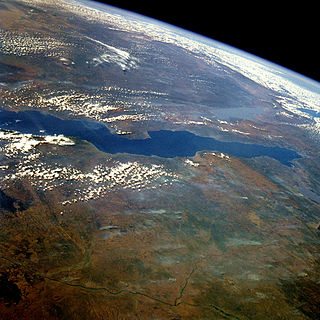
Lake Malawi, also known as Lake Nyasa in Tanzania and Lago Niassa in Mozambique, is an African Great Lake and the southernmost lake in the East African Rift system, located between Malawi, Mozambique and Tanzania.

Lake Victoria is one of the African Great Lakes. The lake was named after Queen Victoria by the explorer John Hanning Speke, the first Briton to document it. Speke accomplished this in 1858, while on an expedition with Richard Francis Burton to locate the source of the Nile River.
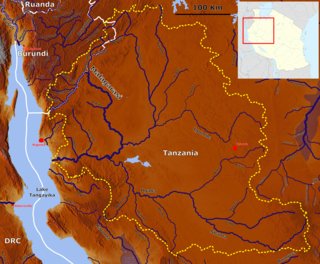
Lake Tanganyika is an African Great Lake. It is the second oldest freshwater lake in the world, the second largest by volume, and the second deepest, in all cases after Lake Baikal in Siberia. It is the world's longest freshwater lake. The lake is divided among four countries – Tanzania, Democratic Republic of the Congo (DRC), Burundi, and Zambia, with Tanzania (46%) and DRC (40%) possessing the majority of the lake. The water flows into the Congo River system and ultimately into the Atlantic Ocean.

Nyumba ya Mungu Dam is a hydroelectric dam in Tanzania. It is in Mwanga District, Kilimanjaro Region. The water runs down the slopes of Kilimanjaro in the deep valleys. These streams pour their water into the Nyumba ya Mungu Reservoir. Nyumba ya Mungu means 'House of God'. Its installed capacity is 8 megawatts (11,000 hp).

Hale Dam is a hydroelectric dam in Tanzania, located in the Tanga Region. Its installed capacity is 21 megawatts (28,000 hp). Thousands of people were displaced to build the dam.

The Pangani suckermouth is a species of upside-down catfish native to Kenya and Tanzania. This species grows to a length of 7 centimetres (2.8 in) SL.

Ctenochromis pectoralis, the Pangani haplo, is a species of fish in the family Cichlidae. It was originally characterized in the Pangani River of Tanzania, and may also be present in Kenya. It is listed as extinct by IUCN as a result of a 1996 evaluation, but this appears to be incorrect. A more recent IUCN publication stated that this species is not endangered in any way.
Oreochromis esculentus, the Singida tilapia or Graham's tilapia, is a critically endangered species of cichlid endemic to the Lake Victoria basin, including some of its satellite lakes such as Kyoga, in Tanzania, Uganda, and Kenya.
The Pangani robber is a species of fish in the family Alestidae. It is found in the Tanga and Pangani River drainages, including Lake Jipe, in Tanzania and Kenya. Its natural habitats are rivers and lagoons.
The Malagarasi River is a river in western Tanzania, flowing through Kigoma Region, although one of its tributaries comes from southeastern Burundi. It is the second-longest river in Tanzania behind the Rufiji—Great Ruaha, and has the largest watershed of any river flowing into Lake Tanganyika. The Malagarasi-Muyovozi Wetlands are a designated a Ramsar site. Local tribes have nicknamed the Malagarasi as "the river of bad spirits".

Tanzania contains some 20 percent of the species of Africa’s large mammal population, found across its reserves, conservation areas, marine parks, and 17 national parks, spread over an area of more than 42,000 square kilometres (16,000 sq mi) and forming approximately 38 percent of the country's territory. Wildlife resources of Tanzania are described as "without parallel in Africa" and "the prime game viewing country". Serengeti National Park, the country's second largest national park area at 14,763 square kilometres (5,700 sq mi), is located in northern Tanzania and is famous for its extensive migratory herds of wildebeests and zebra while also having the reputation as one of the great natural wonders of the world. The Ngorongoro Conservation Area, established in 1959, is a UNESCO World Heritage Site and inhabited by the Maasai people. Its Ngorongoro Crater is the largest intact caldera in the world.

Lake Burigi is an endorheic lake in the Karagwe district, Kagera Region of Tanzania. Parts of the lake and its shore are situated within the Burigi Game Reserve.
The River Lumi is located in northern Tanzania and southern Kenya in Coast Province. It originates on the east side of Mawenzi, and flows so close to the River Rombo as almost to form a fork. The Lumi, however, maintains its southerly direction, and may thus be said to represent the upper course of the Ruvu, one of tho two main sources of the Pangani River. It flows around the Lake Chala and the Taveta town in the west and empties into the Lake Jipe. The fish species Barbus sp. 'Pangani' has only been found in the river's N'joro Springs, situated in the upper Pangani River drainage basin.

The Pangani River (pin-gi'nee) is a major river of northeastern Tanzania. It has two main sources: the Ruvu, which rises as Lumi at Kilimanjaro, passes through Lake Jipe, and empties into the Nyumba ya Mungu Reservoir, and the Kikuletwa, coming from the west and mainly fed by Mount Meru, which also enters into the Nyumba ya Mungu Reservoir. Just after leaving the reservoir the stream becomes the Pangani, which empties into the Indian Ocean at the town of Pangani.
Mkulumuzi River is a river of Tanzania. It is part of the Pangani River basin.
Msangazi River is a river of Tanzania. It is part of the Pangani River basin.

Loch Dornal is an irregular shaped, shallow, freshwater loch in Strathclyde, in the Southern Uplands of south-west Scotland. It lies approximately 8 mi (13 km) northwest of the town of Newton Stewart.


